65.229.10.248 - IP Lookup: Free IP Address Lookup, Postal Code Lookup, IP Location Lookup, IP ASN, Public IP
Country:
Region:
City:
Location:
Time Zone:
Postal Code:
IP information under different IP Channel
ip-api
Country
Region
City
ASN
Time Zone
ISP
Blacklist
Proxy
Latitude
Longitude
Postal
Route
Luminati
Country
ASN
Time Zone
America/Chicago
ISP
CELLCO-PART
Latitude
Longitude
Postal
IPinfo
Country
Region
City
ASN
Time Zone
ISP
Blacklist
Proxy
Latitude
Longitude
Postal
Route
IP2Location
65.229.10.248Country
Region
washington
City
kent
Time Zone
America/Los_Angeles
ISP
Language
User-Agent
Latitude
Longitude
Postal
db-ip
Country
Region
City
ASN
Time Zone
ISP
Blacklist
Proxy
Latitude
Longitude
Postal
Route
ipdata
Country
Region
City
ASN
Time Zone
ISP
Blacklist
Proxy
Latitude
Longitude
Postal
Route
Popular places and events near this IP address

Kent, Washington
City in Washington, United States
Distance: Approx. 2828 meters
Latitude and longitude: 47.38277778,-122.22694444
Kent is a city in King County, Washington, United States. It is part of the Seattle–Tacoma–Bellevue metropolitan area and had a population of 136,588 as of the 2020 census, making it the 4th most populous municipality in greater Seattle and the 6th most populous in Washington state. The city is connected to Seattle, Bellevue and Tacoma via State Route 167 and Interstate 5, Sounder commuter rail, and commuter buses.
Highline College
Community college in Des Moines, Washington, US
Distance: Approx. 2891 meters
Latitude and longitude: 47.38861111,-122.30083333
Highline College is a public community college in Des Moines, Washington. Highline was founded in 1961 as the first community college in King County, Washington. The main campus covers 80 acres (320,000 m2).
Accesso ShoWare Center
Multi-use indoor arena in Kent, Washington
Distance: Approx. 1723 meters
Latitude and longitude: 47.38833333,-122.24
The accesso ShoWare Center is a multi-purpose arena in Kent, Washington, United States.

Kent station (Sound Transit)
Commuter train station in Kent, Washington
Distance: Approx. 2342 meters
Latitude and longitude: 47.38416667,-122.23305556
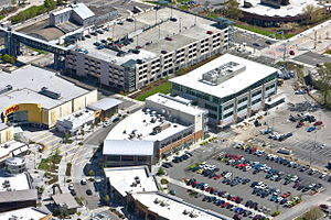
Kent station is a train station in the city of Kent, Washington, United States, served by the S Line of the Sounder commuter rail network. It is located in downtown Kent and consists of two train platforms connected via a pedestrian overpass, a parking garage, and several bus bays. The station also has 996 parking stalls and is served by King County Metro and Sound Transit Express buses.
1965 Puget Sound earthquake
Earthquake in Washington
Distance: Approx. 3002 meters
Latitude and longitude: 47.4,-122.3
The 1965 Puget Sound earthquake occurred at 08:28 AM PDT (15:28 UTC) on April 29 within the Puget Sound region of Washington state. It had a magnitude of 6.7 on the moment magnitude scale and a maximum perceived intensity of VIII (Severe) on the Mercalli intensity scale. It caused the deaths of seven people and about $12.5–28 million in damage.
Cottonwood Grove Park
Distance: Approx. 706 meters
Latitude and longitude: 47.38805556,-122.27111111
Cottonwood Grove Park is a .77-acre (0.31-hectare) park in the city of Kent, Washington. It is located on the banks of the Green River off Frager Road, at approximately the 23800 block South. In March 1986, remains from a victim of serial killer Gary Ridgway (the Green River Killer) were found in the park.

Mill Creek Canyon Earthworks
Public park, dam, and piece of art in Kent, Washington
Distance: Approx. 3033 meters
Latitude and longitude: 47.383,-122.224
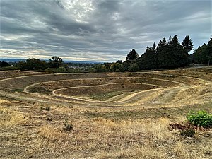
The Mill Creek Canyon Earthworks is a public park, storm water detention dam and Modernist "masterpiece" of environmental art located in Kent, Washington, United States. The earthworks was created by Bauhaus artist Herbert Bayer in 1982 and designated a landmark by King County Landmarks Commission in 2008. The earthworks site covers 2.5 acres (1.0 ha).

Washington's 33rd legislative district
Distance: Approx. 1405 meters
Latitude and longitude: 47.4,-122.25
Washington's 33rd legislative district is one of forty-nine districts in Washington for representation in the state legislature. It is in King County and consists of east Burien, Normandy Park, SeaTac, Des Moines and parts of Kent, Tukwila, and Renton. The district is represented by three Democrats: Tina Orwall (Senate), Edwin Obras (House, position 1), and Mia Gregerson (House, position 2).
Seattle Impact
Soccer club
Distance: Approx. 1723 meters
Latitude and longitude: 47.38833333,-122.24
Seattle Impact FC was an American professional indoor soccer team that began play as a member of the Major Arena Soccer League with its 2014-15 season. Based in Seattle, Washington, the Impact played its home games at the ShoWare Center in nearby Kent. After struggles on and off the field, the team's assets were sold mid-season to Lane Smith whose Tacoma Stars completed Seattle's scheduled 2015 regular season games.
Kent Des Moines station
Future light rail station in Kent, Washington
Distance: Approx. 2297 meters
Latitude and longitude: 47.3892,-122.293
Kent Des Moines station is a future station on Sound Transit's Federal Way Link Extension, part of the Link light rail system. It is to be located in western Kent, Washington near Highline College. It is scheduled to open in 2026 as part of the extension of the 1 Line to Federal Way Transit Center.

Robert Morris Earthwork
Distance: Approx. 2450 meters
Latitude and longitude: 47.407501,-122.283607
The Robert Morris Earthwork is a 1979 public art earthworks installation in Seatac, Washington by Robert Morris. The area surrounding the piece, a former gravel pit overlooking the Kent Valley outside of Seattle, has been rapidly filled in with urban growth, leading to efforts to both protect it and to enhance public access and enjoyment. The earthwork was the result of a King County government symposium titled Earthworks: Land Reclamation as Sculpture.

Lake Fenwick
Lake in Kent, Washington
Distance: Approx. 2842 meters
Latitude and longitude: 47.36583333,-122.27111111
Lake Fenwick is located in King County, Washington, United States, mostly within the city of Kent. The lake is known for its recreational opportunities including fishing and a large public park. The lake has suffered from poor water quality, algae, and infestation by aquatic weeds.
Weather in this IP's area
overcast clouds
6 Celsius
4 Celsius
5 Celsius
8 Celsius
1032 hPa
88 %
1032 hPa
1022 hPa
10000 meters
3.6 m/s
20 degree
100 %
