65.182.137.251 - IP Lookup: Free IP Address Lookup, Postal Code Lookup, IP Location Lookup, IP ASN, Public IP
Country:
Region:
City:
Location:
Time Zone:
Postal Code:
ISP:
ASN:
language:
User-Agent:
Proxy IP:
Blacklist:
IP information under different IP Channel
ip-api
Country
Region
City
ASN
Time Zone
ISP
Blacklist
Proxy
Latitude
Longitude
Postal
Route
db-ip
Country
Region
City
ASN
Time Zone
ISP
Blacklist
Proxy
Latitude
Longitude
Postal
Route
IPinfo
Country
Region
City
ASN
Time Zone
ISP
Blacklist
Proxy
Latitude
Longitude
Postal
Route
IP2Location
65.182.137.251Country
Region
georgia
City
lincolnton
Time Zone
America/New_York
ISP
Language
User-Agent
Latitude
Longitude
Postal
ipdata
Country
Region
City
ASN
Time Zone
ISP
Blacklist
Proxy
Latitude
Longitude
Postal
Route
Popular places and events near this IP address

Lincoln County, Georgia
County in Georgia, United States
Distance: Approx. 2696 meters
Latitude and longitude: 33.79,-82.45
Lincoln County is a county located in the east central portion of the U.S. state of Georgia. As of the 2020 census, the population was 7,690. The county seat is Lincolnton.

Lincolnton, Georgia
City in Georgia, United States
Distance: Approx. 332 meters
Latitude and longitude: 33.79444444,-82.47638889
Lincolnton is a city and the county seat of Lincoln County, Georgia, United States. The population was 1,480 at the 2020 census. It contains numerous houses and historic districts listed on the National Register of Historic Places.

Elijah Clark State Park
State park in Georgia, USA
Distance: Approx. 8830 meters
Latitude and longitude: 33.8545,-82.41959444
Elijah Clark State Park is a 447-acre (1.81 km2) Georgia state park located in Lincolnton, on the western shore of Lake Strom Thurmond. The park is named for Elijah Clarke, a frontiersman and war hero who led a force of pioneers in Georgia during the American Revolution. A reconstructed log cabin displays colonial life with furniture and tools dating back to 1780.
Lincoln County High School (Georgia)
School in Lincolnton, Georgia, United States
Distance: Approx. 274 meters
Latitude and longitude: 33.793257,-82.476221
Lincoln County High School is a high school in Lincolnton, Georgia, United States. Its motto is "Forever Learning, Forever Leading". It is the successor of Lincolnton High School.
Lincoln County School District (Georgia)
School district in Georgia (U.S. state)
Distance: Approx. 6176 meters
Latitude and longitude: 33.817242,-82.538701
The Lincoln County School District is a public school district in Lincoln County, Georgia, United States, based in Lincolnton. It serves the communities of Chennault and Lincolnton.
Lincolnton Presbyterian Church and Cemetery
Historic site in Lincoln County, Georgia, US
Distance: Approx. 277 meters
Latitude and longitude: 33.79027778,-82.48055556
Lincolnton Presbyterian Church and Cemetery is a historic Presbyterian church and its cemetery on N. Washington Street in Lincolnton, Georgia, in Lincoln County, Georgia. The property was added to the National Register in 1982. The church building was built in c.1823 and was known as Union Presbyterian Church.
Agnes, Georgia
Distance: Approx. 6971 meters
Latitude and longitude: 33.7459606,-82.4284607
Agnes is an extinct town in Lincoln County, in the U.S. state of Georgia.
Goshen, Georgia
Unincorporated community in Georgia, U.S.
Distance: Approx. 8362 meters
Latitude and longitude: 33.86361111,-82.50777778
Goshen is an unincorporated community in Lincoln County, in the U.S. state of Georgia.

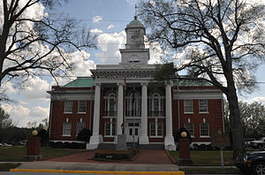
Lincoln County Courthouse (Georgia)
United States historic place
Distance: Approx. 392 meters
Latitude and longitude: 33.79451,-82.47561
The Lincoln County Courthouse, on Courthouse Sq. in Lincolnton, Georgia, was built in 1915. It was listed on the National Register of Historic Places in 1980.
Lincolnton Historic District
Historic district in Georgia, United States
Distance: Approx. 199 meters
Latitude and longitude: 33.79138889,-82.47722222
The Lincolnton Historic District, in Lincolnton, Georgia, is a historic district which was listed on the National Register of Historic Places in 1993. It included 126 contributing buildings, a contributing structure, a contributing site, and a contributing object. The district runs roughly along Washington, Peachtree, Goshen and Elm Streets in Lincolnton, and covers an area of 280 acres (1.1 km2).
Weather in this IP's area
scattered clouds
3 Celsius
1 Celsius
3 Celsius
3 Celsius
1028 hPa
56 %
1028 hPa
1011 hPa
10000 meters
2.06 m/s
3.59 m/s
318 degree
37 %

