65.15.187.3 - IP Lookup: Free IP Address Lookup, Postal Code Lookup, IP Location Lookup, IP ASN, Public IP
Country:
Region:
City:
Location:
Time Zone:
Postal Code:
ISP:
ASN:
language:
User-Agent:
Proxy IP:
Blacklist:
IP information under different IP Channel
ip-api
Country
Region
City
ASN
Time Zone
ISP
Blacklist
Proxy
Latitude
Longitude
Postal
Route
db-ip
Country
Region
City
ASN
Time Zone
ISP
Blacklist
Proxy
Latitude
Longitude
Postal
Route
IPinfo
Country
Region
City
ASN
Time Zone
ISP
Blacklist
Proxy
Latitude
Longitude
Postal
Route
IP2Location
65.15.187.3Country
Region
louisiana
City
natchitoches
Time Zone
America/Chicago
ISP
Language
User-Agent
Latitude
Longitude
Postal
ipdata
Country
Region
City
ASN
Time Zone
ISP
Blacklist
Proxy
Latitude
Longitude
Postal
Route
Popular places and events near this IP address
Northwestern State University
Public university in Natchitoches, Louisiana, US
Distance: Approx. 1576 meters
Latitude and longitude: 31.75,-93.0972
Northwestern State University of Louisiana (NSULA) is a public university primarily situated in Natchitoches, Louisiana, with a nursing campus in Shreveport and general campuses in Leesville/Fort Johnson and Alexandria. It is a part of the University of Louisiana System. NSU was founded in 1884 as the Louisiana State Normal School.
Louisiana School for Math, Science, and the Arts
Public school in Louisiana, United States
Distance: Approx. 1280 meters
Latitude and longitude: 31.7526,-93.0959
The Louisiana School for Math, Science, and the Arts (LSMSA) is a public residential high school located in Natchitoches, Louisiana, US on the campus of Northwestern State University (NSU). It is a member of the National Consortium for Specialized Secondary Schools of Mathematics, Science and Technology (NCSSSMST). In 2016, Niche ranked LSMSA the 9th best public high school nationwide.
St. Mary's High School (Natchitoches, Louisiana)
Private, coeducational school in Natchitoches, Louisiana, United States
Distance: Approx. 1275 meters
Latitude and longitude: 31.76916667,-93.07722222
St. Mary's High School is a private coeducational Roman Catholic high school in Natchitoches, Louisiana located in the Diocese of Alexandria.

Natchitoches Historic District
Historic district in Louisiana, United States
Distance: Approx. 897 meters
Latitude and longitude: 31.75433,-93.092108
Natchitoches Historic District ( NAK-ə-tish; named after the indigenous people of the area), also known as Natchitoches National Historic Landmark District, is a historic district encompassing the heart of Natchitoches, Louisiana, the oldest permanent European settlement in what is now Louisiana, and the oldest permanent European settlement in the wider geographic area involved in the Louisiana Purchase. It was founded by the French in 1714 and declared a National Historic Landmark in 1984.
Natchitoches Parish School Board
School board for district in Louisiana, US
Distance: Approx. 1427 meters
Latitude and longitude: 31.7487,-93.081
Natchitoches Parish School Board (NPSB) is a school district headquartered in Natchitoches, Louisiana, United States. The current Superintendent is Dr. Grant Eloi.

Guy House (Natchitoches, Louisiana)
Historic house in Louisiana, United States
Distance: Approx. 793 meters
Latitude and longitude: 31.75434,-93.09007
Guy House, located at 309 Pine Street, Natchitoches, Louisiana, United States, is a one-and-a-half-story Greek Revival house built in c.1850 by Samuel Eldridge Guy. It was listed on the National Register of Historic Places in 1988. It is a "galleried cottage", i.e.

Old Courthouse Museum – Natchitoches
Distance: Approx. 174 meters
Latitude and longitude: 31.7612,-93.08804
The Old Courthouse Museum – Natchitoches is a former courthouse is located at 600 Second Street Natchitoches, Louisiana. The museum was formerly operated as a branch of Louisiana State Museum that displayed temporary exhibits of art and local history. It is no longer open to the public as a museum.

Rebel State Historic Site
Historic site in Louisiana, USA
Distance: Approx. 1254 meters
Latitude and longitude: 31.749444,-93.086944
Rebel State Historic Site is operated by the state of Louisiana and is located near Marthaville in Natchitoches Parish. The historic site commemorates the history and culture of northwestern Louisiana. The site, formerly a state commemorative area, was originally meant to honor an unknown Confederate soldier who was killed in the vicinity by three Union cavalrymen.

Fort St. Jean Baptiste State Historic Site
American fort in Natchitoches, Louisiana
Distance: Approx. 954 meters
Latitude and longitude: 31.752222,-93.087778
Fort St. Jean Baptiste State Historic Site in Natchitoches, Louisiana, US, is a replica of an early French fort based upon the original 1716 blueprints by Sieur Du Tisné with the improvements made in 1731 by Boutin. The French called the original fort: Fort Saint Jean Baptiste des Natchitoches.

H. Alvin Brown–C. C. Stroud Field
Distance: Approx. 1680 meters
Latitude and longitude: 31.74705556,-93.09388889
Brown–Stroud Field is a baseball venue in Natchitoches, Louisiana, United States. It is home to the Northwestern State Demons baseball team of the NCAA Division I Southland Conference. Opened on April 1, 1939, the venue has a capacity of 1,200 spectators.

Basilica of the Immaculate Conception (Natchitoches, Louisiana)
Historic church in Louisiana, United States
Distance: Approx. 122 meters
Latitude and longitude: 31.76111111,-93.0875
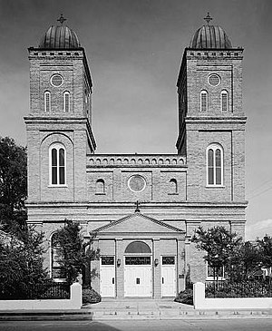
The Basilica of the Immaculate Conception is a minor basilica located in Natchitoches, Louisiana, United States. It is also a parish church in the Diocese of Alexandria. The church building is the seventh structure to house the parish and was at one time the cathedral for the Roman Catholic Diocese of Natchitoches.
Caspiana Plantation Store
Historic building, former plantation store
Distance: Approx. 1431 meters
Latitude and longitude: 31.770278,-93.096389
Caspiana Plantation Store is an American historic building and a former plantation store built in 1906, located at 1300 Texas Street in Natchitoches, Louisiana. The store served as part of the crop-lien system, during the time of sharecropping which impacted the lives of many African American workers. It is listed as a National Register of Historic Places since June 5, 1992 for its agricultural history and significance.
Weather in this IP's area
clear sky
-1 Celsius
-1 Celsius
-1 Celsius
-1 Celsius
1028 hPa
80 %
1028 hPa
1023 hPa
10000 meters

