65.13.197.39 - IP Lookup: Free IP Address Lookup, Postal Code Lookup, IP Location Lookup, IP ASN, Public IP
Country:
Region:
City:
Location:
Time Zone:
Postal Code:
ISP:
ASN:
language:
User-Agent:
Proxy IP:
Blacklist:
IP information under different IP Channel
ip-api
Country
Region
City
ASN
Time Zone
ISP
Blacklist
Proxy
Latitude
Longitude
Postal
Route
db-ip
Country
Region
City
ASN
Time Zone
ISP
Blacklist
Proxy
Latitude
Longitude
Postal
Route
IPinfo
Country
Region
City
ASN
Time Zone
ISP
Blacklist
Proxy
Latitude
Longitude
Postal
Route
IP2Location
65.13.197.39Country
Region
georgia
City
savannah
Time Zone
America/New_York
ISP
Language
User-Agent
Latitude
Longitude
Postal
ipdata
Country
Region
City
ASN
Time Zone
ISP
Blacklist
Proxy
Latitude
Longitude
Postal
Route
Popular places and events near this IP address

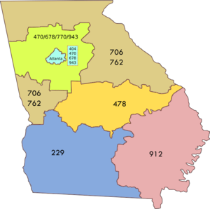
Area code 912
Telephone area code for southeastern Georgia, United States
Distance: Approx. 301 meters
Latitude and longitude: 32.08233,-81.09652
Area code 912 is a telephone area code in the North American Numbering Plan (NANP) for the southeastern part of the U.S. state of Georgia. The numbering plan area contains Savannah, Richmond Hill, Hinesville, Vidalia, Metter, Reidsville, Homerville, Waycross, Brunswick, Folkston, Douglas, Statesboro, Ludowici, Jesup and Kingsland. The area code was created in 1954 in an area code split from area code 404, which had been assigned to the entire state in 1947.

William Scarbrough House
United States historic place
Distance: Approx. 328 meters
Latitude and longitude: 32.08117,-81.09727
William Scarbrough House is a historic house in Savannah, Georgia. Built in 1819, and subjected to a number later alterations, it is nationally significant as an early example of Greek Revival architecture, and is one of the few surviving American works of architect William Jay. The house was declared a National Historic Landmark in 1973.

First Bryan Baptist Church
Historic church in Georgia, United States
Distance: Approx. 161 meters
Latitude and longitude: 32.08208,-81.09906
Historic First Bryan Baptist Church is an African-American church that was organized in Savannah, Georgia, by Andrew Bryan in 1788. Considered to be the Mother Church of Black Baptists, the site was purchased in 1793 by Bryan, a former slave who had also purchased his freedom. The first structure was erected there in 1794.
Club One (bar)
Night club in Savannah, Georgia
Distance: Approx. 477 meters
Latitude and longitude: 32.08166667,-81.09483333
Club One is a night club located on Jefferson Street in Savannah, Georgia, famous for its drag shows featuring The Lady Chablis. It rose to prominence in part due to Midnight in the Garden of Good and Evil, in which Chablis was featured.

Atlantic Greyhound Bus Terminal
United States historic place
Distance: Approx. 442 meters
Latitude and longitude: 32.079828,-81.097621
The Atlantic Greyhound Bus Terminal, at 109 Martin Luther King, Jr. Blvd. in Savannah, Georgia was listed on the National Register of Historic Places in 2016.

Franklin Square (Savannah, Georgia)
Public square in Savannah, Georgia
Distance: Approx. 432 meters
Latitude and longitude: 32.081,-81.0959
Franklin Square is one of the 22 squares of Savannah, Georgia, United States. It is located in the northernmost row of the city's five rows of squares, at Montgomery Street and West St. Julian Street.

City Market (Savannah, Georgia)
Shopping mall in Georgia, United States
Distance: Approx. 511 meters
Latitude and longitude: 32.080829,-81.094998
City Market is a historic market complex in the Historic District of Savannah, Georgia. Originally centered on the site of today's Ellis Square from 1733, today it stretches west from Ellis Square to Franklin Square. Established in the 1700s with a wooden building, locals gathered here for their groceries and services.

Lowden Building
Historic building in Georgia
Distance: Approx. 554 meters
Latitude and longitude: 32.0823,-81.0937
Lowden Building is a historic building in Savannah, Georgia, United States. Located in Savannah's Historic District, the addresses of some of the properties are West Bay Street, above Factors Walk, while others solely utilize the former King Cotton warehouses on River Street. As of February 2022, these are Land & Sea Wear, The Black Dog, Perkins & Sons Chandlery and Earthbound Trading Company.

220–230 West Bay Street
Historic building in Georgia
Distance: Approx. 521 meters
Latitude and longitude: 32.0825,-81.094
220–230 West Bay Street (also known as the Johnston Range) is a row of three historic buildings in Savannah, Georgia, United States. Located in Savannah's Historic District, the addresses of some of the properties are West Bay Street, above Factors Walk, while others solely utilize the former King Cotton warehouses on River Street. As of February 2022, these are Nourish, Harley-Davidson Motory Cycles, Charleston Hemp Collective and Dub's Public House.

John Williamson Range
Historic building in Georgia
Distance: Approx. 480 meters
Latitude and longitude: 32.0827,-81.0944
John Williamson Range is a historic building in Savannah, Georgia, United States. Located in Savannah's Historic District, the addresses of some of the properties are West Bay Street, above Factors Walk, while others solely utilize the former King Cotton warehouses on River Street. As of February 2022, these are Two Cracked Eggs, Rusty Rudders Tap House, Nine Line, Black Rifle Coffee Company and 309 West.
Abram Minis Building
Historic house in Savannah, Georgia
Distance: Approx. 450 meters
Latitude and longitude: 32.08117562,-81.095501
The Abram Minis Building is a historic building in Savannah, Georgia, United States. Located in the northeastern trust block of Franklin Square, at 317 West Bryan Street and 20–22 Montgomery Street, it dates to 1846, making it the oldest extant building on the square. It was built as a commercial property for 26-year-old Abraham Minis, a prominent merchant of the city and founder of A. Minis & Sons.

Sweet Georgia Brown's
Piano bar in Savannah, Georgia
Distance: Approx. 484 meters
Latitude and longitude: 32.081,-81.0952
Sweet Georgia Brown's was a piano bar in Savannah, Georgia. Located at 312 West St. Julian Street, on Franklin Square in Savannah's City Market, the bar was co-owned by musicians Joe Odom and Nancy Hillis, real-life characters in John Berendt's book Midnight in the Garden of Good and Evil (1994).
Weather in this IP's area
clear sky
-0 Celsius
-0 Celsius
-1 Celsius
1 Celsius
1031 hPa
90 %
1031 hPa
1030 hPa
10000 meters
