64.98.140.242 - IP Lookup: Free IP Address Lookup, Postal Code Lookup, IP Location Lookup, IP ASN, Public IP
Country:
Region:
City:
Location:
Time Zone:
Postal Code:
IP information under different IP Channel
ip-api
Country
Region
City
ASN
Time Zone
ISP
Blacklist
Proxy
Latitude
Longitude
Postal
Route
Luminati
Country
Region
co
City
centennial
ASN
Time Zone
America/Denver
ISP
AS-TING-BACKBONE
Latitude
Longitude
Postal
IPinfo
Country
Region
City
ASN
Time Zone
ISP
Blacklist
Proxy
Latitude
Longitude
Postal
Route
IP2Location
64.98.140.242Country
Region
colorado
City
centennial
Time Zone
America/Denver
ISP
Language
User-Agent
Latitude
Longitude
Postal
db-ip
Country
Region
City
ASN
Time Zone
ISP
Blacklist
Proxy
Latitude
Longitude
Postal
Route
ipdata
Country
Region
City
ASN
Time Zone
ISP
Blacklist
Proxy
Latitude
Longitude
Postal
Route
Popular places and events near this IP address

Castlewood, Colorado
Neighborhood in Arapahoe County, Colorado, United States
Distance: Approx. 2164 meters
Latitude and longitude: 39.5847104,-104.9010903
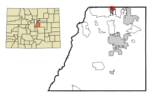
Castlewood is a neighborhood in the City of Centennial, Colorado. A former census-designated place (CDP), the population was 25,567 at the 2000 census. It has been a part of the City of Centennial since the city's incorporation in 2001.

Acres Green, Colorado
Census Designated Place in State of Colorado, United States of America
Distance: Approx. 2998 meters
Latitude and longitude: 39.5567,-104.8961
Acres Green is an unincorporated community and a census-designated place (CDP) located in and governed by Douglas County, Colorado, United States. The CDP is a part of the Denver–Aurora–Lakewood, CO Metropolitan Statistical Area. The population of the Acres Green CDP was 2,922 at the 2020 United States Census.
Centennial Airport
Airport in Dove Valley, Colorado, United States
Distance: Approx. 2569 meters
Latitude and longitude: 39.57,-104.84944444
Centennial Airport (IATA: APA, ICAO: KAPA, FAA LID: APA) is a public use airport owned by the Arapahoe County Public Airport Authority in the Denver-Aurora metropolitan area, 15 nautical miles (17 mi, 28 km) southeast of downtown Denver, Colorado, United States. Located in Dove Valley, a census designated place in Arapahoe County, the airport's runways extend into Douglas County.

Arrow Electronics
American company
Distance: Approx. 1431 meters
Latitude and longitude: 39.590568,-104.869118
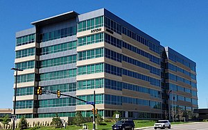
Arrow Electronics, Inc. is an American Fortune 500 company headquartered in Centennial, Colorado. A global provider of electronic components and enterprise computing products, the company specializes in distribution and value-added services for original equipment manufacturers, value-added resellers, managed service providers, contract manufacturers and other commercial customers.
National Cattlemen's Beef Association
Distance: Approx. 1056 meters
Latitude and longitude: 39.570709,-104.882381
National Cattlemen's Beef Association (NCBA) is an American trade association and lobbying group working for American beef producers.

Arapahoe at Village Center station
Light rail station in Greenwood Village, Colorado
Distance: Approx. 2575 meters
Latitude and longitude: 39.6005,-104.8886
Arapahoe at Village Center station is a light rail station in Greenwood Village, Colorado, United States. It is served by the E and R Lines, operated by the Regional Transportation District (RTD), and was opened on November 17, 2006. In addition to numerous office buildings and corporate campuses, the station is the destination for people attending concerts at the Fiddler's Green Amphitheatre.
Dry Creek station
Light rail station in Centennial, Colorado
Distance: Approx. 84 meters
Latitude and longitude: 39.5786,-104.8763
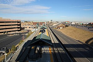
Dry Creek station is a light rail station in Centennial, Colorado, United States. It is served by the E and R Lines, operated by the Regional Transportation District (RTD), and was opened on November 17, 2006. The station features a public art installation of a series of stainless steel tubes holding hourglasses that contain pyrite entitled Fools Gold.
County Line station (RTD)
Light rail station in Lone Tree, Colorado
Distance: Approx. 1957 meters
Latitude and longitude: 39.562,-104.8722
County Line station is a light rail station in Lone Tree, Colorado, United States. It is served by the E and R Lines, operated by the Regional Transportation District (RTD), and was opened on November 17, 2006. It serves Park Meadows Mall and features a public art sculpture entitled Plow, created by Emmett Culligan and dedicated in 2006.
Fiddler's Green Amphitheatre
Concert venue in Colorado, United States
Distance: Approx. 2786 meters
Latitude and longitude: 39.60049167,-104.89396111
Fiddler's Green Amphitheatre (formerly Comfort Dental Amphitheatre and Coors Amphitheatre) is an 18,000-person capacity amphitheatre located in Greenwood Village, Colorado, United States. It is the largest outdoor amphitheatre in the Denver metropolitan area and is generally open every year from May to September.

Museum of Outdoor Arts
Art museum in Greenwood Village, Colorado
Distance: Approx. 2962 meters
Latitude and longitude: 39.6024266,-104.893743
Museum of Outdoor Arts (MOA) is a non-profit museum and gallery based in Englewood, Colorado. It was founded in 1981 by John W. Madden, Jr. and his daughter, Cynthia Madden Leitner.

Inverness, Colorado
Census Designated Place in Colorado, United States
Distance: Approx. 1062 meters
Latitude and longitude: 39.5758272,-104.8653211
Inverness is an unincorporated community and a census-designated place (CDP) located in and governed by Arapahoe County, Colorado, United States. The CDP is a part of the Denver–Aurora–Lakewood, CO Metropolitan Statistical Area. The population of the Inverness CDP was 2,226 at the United States Census 2020.
Park Meadows
Shopping mall in Colorado, United States
Distance: Approx. 1847 meters
Latitude and longitude: 39.56261,-104.87634
Park Meadows is an enclosed shopping mall in Lone Tree, Colorado, that includes a gross leasable area of 1,576,618 square feet (150,000 m2). Opened on August 30, 1996, the mall features JCPenney, Macy's, Dillard's, Nordstrom, and Dick's Sporting Goods.
Weather in this IP's area
broken clouds
2 Celsius
-3 Celsius
0 Celsius
3 Celsius
1018 hPa
33 %
1018 hPa
822 hPa
10000 meters
5.14 m/s
90 degree
75 %


