Country:
 USA
USARegion:
City:
Latitude and Longitude:
Time Zone:
Postal Code:
IP information under different IP Channel
ip-api
Country
Region
City
ASN
Time Zone
ISP
Blacklist
Proxy
Latitude
Longitude
Postal
Route
IPinfo
Country
Region
City
ASN
Time Zone
ISP
Blacklist
Proxy
Latitude
Longitude
Postal
Route
MaxMind
Country
Region
City
ASN
Time Zone
ISP
Blacklist
Proxy
Latitude
Longitude
Postal
Route
Luminati
Country
USASN
Time Zone
America/Chicago
ISP
INTERNAP-2BLK
Latitude
Longitude
Postal
db-ip
Country
Region
City
ASN
Time Zone
ISP
Blacklist
Proxy
Latitude
Longitude
Postal
Route
ipdata
Country
Region
City
ASN
Time Zone
ISP
Blacklist
Proxy
Latitude
Longitude
Postal
Route
Popular places and events near this IP address
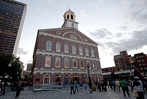
Faneuil Hall
United States historic place in Boston, MA (opened 1743)
Distance: Approx. 97 meters
Latitude and longitude: 42.36,-71.05625
Faneuil Hall ( or ; previously ) is a marketplace and meeting hall located near the waterfront and today's Government Center, in Boston, Massachusetts. Opened in 1742, it was the site of several speeches by Samuel Adams, James Otis, and others encouraging independence from Great Britain. It is now part of Boston National Historical Park and a well-known stop on the Freedom Trail.

Freedom Trail
Historical walking trail in Boston, Massachusetts
Distance: Approx. 131 meters
Latitude and longitude: 42.36,-71.05666667
The Freedom Trail is a 2.5-mile-long (4.0 km) path through Boston that passes by 16 locations significant to the history of the United States. It winds from Boston Common in downtown Boston, to the Old North Church in the North End and the Bunker Hill Monument in Charlestown. Stops along the trail include simple explanatory ground markers, graveyards, notable churches and buildings, and a historic naval frigate.
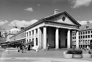
Quincy Market
Historic landmark in Boston, US
Distance: Approx. 24 meters
Latitude and longitude: 42.36,-71.055
Quincy Market is a historic building near Faneuil Hall in downtown Boston, Massachusetts. It was constructed between 1824 and 1826 and named in honor of mayor Josiah Quincy, who organized its construction without any tax or debt. The market is a designated National Historic Landmark and a designated Boston Landmark in 1996, significant as one of the largest market complexes built in the United States in the first half of the 19th century.

Boston National Historical Park
National Historical Park of the United States
Distance: Approx. 108 meters
Latitude and longitude: 42.36,-71.05638889
The Boston National Historical Park is an association of sites that showcase Boston's role in the American Revolution and other parts of history. It was designated a national park on October 1, 1974. Seven of the eight sites are connected by the Freedom Trail, a walking tour of downtown Boston.

Durgin-Park
Restaurant in Boston
Distance: Approx. 33 meters
Latitude and longitude: 42.3605,-71.0551
Durgin-Park ( DUR-ghin-park) was a centuries-old restaurant at 340 Faneuil Hall Marketplace in downtown Boston. The Greater Boston Convention and Visitors Bureau stated that it had been a "landmark since 1827", and it was a popular tourist destination within Quincy Market. The restaurant had entrances on both facades (Faneuil Hall and Clinton Street).
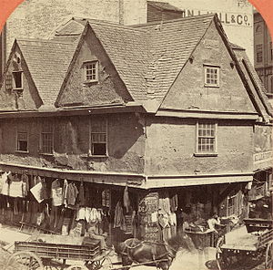
Old Feather Store
Shop in Boston, Massachusetts, United States
Distance: Approx. 144 meters
Latitude and longitude: 42.36014444,-71.05684444
The Old Feather Store (1680–1860) was a shop located at Dock Square and North Street (formerly Ann Street) in Boston, Massachusetts, in the 17th–19th centuries. It was also called the Old Cocked Hat. Built in 1680 by Thomas Stanbury, it was demolished in 1860.

Dock Square
Distance: Approx. 144 meters
Latitude and longitude: 42.36014444,-71.05684444
Dock Square in downtown Boston, Massachusetts, is a public square adjacent to Faneuil Hall, bounded by Congress Street, North Street, and the steps of the 60 State Street office tower. Its name derives from its original (17th-century) location at the waterfront. From the 1630s through the early 19th century, it served boats in the Boston Harbor as "the common landing place, at Bendell's Cove," later called Town Dock.

Merchants Row (Boston)
Distance: Approx. 93 meters
Latitude and longitude: 42.35949444,-71.05570833
Merchants Row in Boston, Massachusetts, is a short street extending from State Street to Faneuil Hall Square in the Financial District. Since the 17th century, it has been a place of commercial activity. It sits close to Long Wharf and Dock Square, hubs of shipping and trade through the 19th century.

A Once and Future Shoreline
Public artwork in Boston, Massachusetts, U.S.
Distance: Approx. 97 meters
Latitude and longitude: 42.36,-71.05625
A Once and Future Shoreline is a permanent public artwork that graphically marks the edge of Boston Harbor, circa 1630, into the granite paving blocks of the plaza on the West side of the historic Faneuil Hall building. The 850-foot-long artwork depicts the location of a pre-colonial shoreline by graphically etching silhouettes of materials that are found typically along the high tide line. The artwork offers a way to engage the imagination in an exploration of the changes to this now urban site from a salty tidal marsh, to an active pedestrian plaza.

Statue of Red Auerbach
Statue in Boston, Massachusetts, U.S.
Distance: Approx. 78 meters
Latitude and longitude: 42.36,-71.05419444
A statue of long-time Boston Celtics coach Red Auerbach by Lloyd Lillie (sometimes called Arnold "Red" Auerbach or Red Auerbach) is installed outside Quincy Market at Faneuil Hall, in Boston, Massachusetts, United States.
Statue of Kevin White
Statue in Boston, Massachusetts, U.S.
Distance: Approx. 134 meters
Latitude and longitude: 42.36025,-71.05672222
A 10-foot (3.0 m) bronze statue of Kevin White by Pablo Eduardo is installed in Boston's Faneuil Hall, in the U.S. state of Massachusetts. The sculpture was installed in 2006.

Fiske Building
Demolished skyscraper in Boston, Massachusetts, USA
Distance: Approx. 140 meters
Latitude and longitude: 42.35895,-71.0553
The Fiske Building, located in Boston, was a 38.1 m (125 ft) skyscraper built by Peabody and Stearns in 1888 and demolished in 1986. In 1964, five stories were added to the building, and the facade was altered with the addition of glass, black aluminum strips and horizontal blue panels, leading architectural observers to describe the building as one of the ugliest in Boston.
Weather in this IP's area
few clouds
24 Celsius
24 Celsius
21 Celsius
26 Celsius
1024 hPa
43 %
1024 hPa
1024 hPa
10000 meters
5.66 m/s
100 degree
20 %
06:25:44
18:52:16