Country:
 USA
USARegion:
City:
Latitude and Longitude:
Time Zone:
Postal Code:
IP information under different IP Channel
ip-api
Country
Region
City
ASN
Time Zone
ISP
Blacklist
Proxy
Latitude
Longitude
Postal
Route
IPinfo
Country
Region
City
ASN
Time Zone
ISP
Blacklist
Proxy
Latitude
Longitude
Postal
Route
MaxMind
Country
Region
City
ASN
Time Zone
ISP
Blacklist
Proxy
Latitude
Longitude
Postal
Route
Luminati
Country
USASN
Time Zone
America/Chicago
ISP
NYINTERNET
Latitude
Longitude
Postal
db-ip
Country
Region
City
ASN
Time Zone
ISP
Blacklist
Proxy
Latitude
Longitude
Postal
Route
ipdata
Country
Region
City
ASN
Time Zone
ISP
Blacklist
Proxy
Latitude
Longitude
Postal
Route
Popular places and events near this IP address
Farmers Insurance Open
Golf tournament in San Diego, California, United States
Distance: Approx. 2893 meters
Latitude and longitude: 32.903,-117.245
The Farmers Insurance Open is an annual professional golf tournament on the PGA Tour, held in San Diego, California. The tournament was founded in 1952. It has been held at Torrey Pines Golf Course, a 36-hole public facility owned by the City of San Diego, since 1968.

Torrey Pines State Natural Reserve
State park in California
Distance: Approx. 1568 meters
Latitude and longitude: 32.921,-117.2532
Torrey Pines State Natural Reserve is a coastal state park in San Diego, California. The reserve is one of the wildest stretches of land on the Southern California coast, covering 2,000 acres (810 ha). It is bordered immediately to the south by Torrey Pines Golf Course and to the north by the city of Del Mar.

Torrey Pines Golf Course
Municipal public golf course owned by the city of San Diego, California
Distance: Approx. 2738 meters
Latitude and longitude: 32.9045,-117.2454
Torrey Pines Golf Course is a 36-hole municipal golf facility in La Jolla, a community of San Diego, California. The course sits on the coastal cliffs overlooking the Pacific Ocean, just south of Torrey Pines State Natural Reserve. Opened in 1957, it was built on the site of Camp Callan, a U.S. Army installation during World War II. Torrey Pines has two 18-hole courses, North and South, designed by William Francis Bell.

Torrey Pines State Beach
State park in California, United States
Distance: Approx. 2014 meters
Latitude and longitude: 32.93138889,-117.26027778
Torrey Pines State Beach is a public beach in San Diego, California, located in a community of Torrey Pines, south of Del Mar and north of La Jolla. Coastal erosion from the adjacent Torrey Pines State Natural Reserve makes for a picturesque landscape. The beach is at the base of a series of 300-foot sandstone cliffs of white and golden stone, with a greenish layer sometimes visible at the very bottom.

San Diego Jewish Academy
Private, co-ed school
Distance: Approx. 1381 meters
Latitude and longitude: 32.93445556,-117.22603056
San Diego Jewish Academy (SDJA) is an independent Jewish day school in the Carmel Valley community of San Diego, California. The school is composed of three schools: SDJA Early Childhood Center, Golda Meir Lower School for grades K-5, and Maimonides Upper School for grades 6–12. SDJA is also home to Camp Carmel Creek, a K-5 summer camp that is open to the entire community.
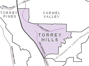
Torrey Hills, San Diego
Community of San Diego in California
Distance: Approx. 2267 meters
Latitude and longitude: 32.91126111,-117.22608889
Torrey Hills is a community of 784 acres (317 ha) located in northern San Diego, California, United States. Torrey Hills is a part of District 1 which is represented by Councilmember Joe LaCava on the San Diego City Council.
2008 U.S. Open (golf)
Golf tournament
Distance: Approx. 2805 meters
Latitude and longitude: 32.904,-117.246
The 2008 United States Open Championship was the 108th U.S. Open, played June 12–16 at Torrey Pines in San Diego, California. Tiger Woods won his third U.S. Open and 14th major title, defeating Rocco Mediate on the first hole of sudden-death, following an 18-hole playoff. With this victory, Woods joined Jack Nicklaus as the only two players to win the career grand slam three times.

Los Peñasquitos Lagoon
Coastal marsh in California, US
Distance: Approx. 1326 meters
Latitude and longitude: 32.9299,-117.25309
Los Peñasquitos Marsh Natural Preserve and Lagoon is a coastal marsh in San Diego County, California, United States situated at the northern edge of the City of San Diego, forming the natural border with Del Mar, California. This bar-built estuary divides a colony of the endangered Torrey pine on a narrow coastal strip. Three streams empty into the lagoon: Carroll Creek, Carmel Creek, and Los Peñasquitos Creek, with a total drainage basin area of 95 square miles.
Soledad Valley
Distance: Approx. 2034 meters
Latitude and longitude: 32.9336,-117.2599
Soledad Valley is a coastal valley in San Diego County, California at the northern end of the city of San Diego. Mention of the valley was made as early as 1850 in association with the occurrence of Pinus torreyana at the mouth of the lagoon. The colony of the endangered Torrey Pine divided by Soledad Valley is one of only two colonies of this tree in the world.

Del Mar Heights, San Diego
Neighborhood in San Diego, California
Distance: Approx. 1726 meters
Latitude and longitude: 32.9425,-117.24694444
Del Mar Heights is an upscale neighborhood near the coast in San Diego, California, bordered by Solana Beach to the north, North City and Carmel Valley to the east, Del Mar to the west, and Torrey Pines to the south. I-5 forms the eastern boundary. It is noted for its hills.

Guy and Margaret Fleming House
United States historic place
Distance: Approx. 1687 meters
Latitude and longitude: 32.92216,-117.2554
The Guy and Margaret Fleming House, also known as Torrey Pines Reserve Ranger Residence, is a historic house in Torrey Pines State Natural Reserve. It was added to the National Register of Historic Places in June 1998. Guy Fleming was a naturalist and the park custodian of Torrey Pines Reserve.
2021 U.S. Open (golf)
121st U.S. Open
Distance: Approx. 2819 meters
Latitude and longitude: 32.90388889,-117.24611111
The 2021 United States Open Championship was the 121st U.S. Open, the national open golf championship of the United States. It was a 72-hole stroke play tournament that was played June 17–20 on the South Course at Torrey Pines Golf Course in La Jolla, a community of San Diego, California. The South Course previously hosted in 2008, which was won by Tiger Woods in a playoff.
Weather in this IP's area
broken clouds
22 Celsius
22 Celsius
20 Celsius
23 Celsius
1012 hPa
65 %
1012 hPa
1008 hPa
10000 meters
6.26 m/s
8.94 m/s
248 degree
75 %
06:33:38
18:53:45