Country:
Region:
City:
Latitude and Longitude:
Time Zone:
Postal Code:
IP information under different IP Channel
ip-api
Country
Region
City
ASN
Time Zone
ISP
Blacklist
Proxy
Latitude
Longitude
Postal
Route
Luminati
Country
Region
mi
City
saintclair
ASN
Time Zone
America/Detroit
ISP
SCCRESA
Latitude
Longitude
Postal
IPinfo
Country
Region
City
ASN
Time Zone
ISP
Blacklist
Proxy
Latitude
Longitude
Postal
Route
db-ip
Country
Region
City
ASN
Time Zone
ISP
Blacklist
Proxy
Latitude
Longitude
Postal
Route
ipdata
Country
Region
City
ASN
Time Zone
ISP
Blacklist
Proxy
Latitude
Longitude
Postal
Route
Popular places and events near this IP address

Port Huron, Michigan
City in Michigan, United States
Distance: Approx. 2534 meters
Latitude and longitude: 42.98027778,-82.4375
Port Huron is a city in the U.S. state of Michigan and the county seat of St. Clair County. The population was 28,983 at the 2020 census.
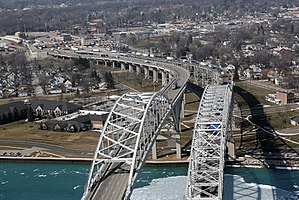
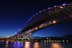
Blue Water Bridge
Twin-span bridge between Point Edward, Ontario, Canada and Port Huron, Michigan, US
Distance: Approx. 2736 meters
Latitude and longitude: 42.99861111,-82.42361111
The Blue Water Bridge is a twin-span international bridge across the St. Clair River that links Port Huron, Michigan, United States, and Point Edward, Ontario, Canada. The Blue Water Bridge connects Highway 402 in Ontario with both Interstate 69 (I-69) and Interstate 94 (I-94) in Michigan.

Thomas Edison Depot Museum
United States historic place
Distance: Approx. 2532 meters
Latitude and longitude: 42.99861111,-82.42611111
The Thomas Edison Depot Museum (previously the Grand Trunk Western Railroad Depot) is a former railway depot located at 520 State Street in Port Huron, Michigan. It has been converted into a museum. The building was listed on the National Register of Historic Places in 1977.

Memorial Recreation Park
Athletic and recreation complex in Port Huron, Michigan
Distance: Approx. 2788 meters
Latitude and longitude: 42.9736634,-82.4485946
Memorial Recreation Park is an athletic and recreation complex in Port Huron, Michigan. The main facility of the complex is a 5,500-seat stadium, home to the Port Huron Northern High School and Port Huron High School football teams. In addition, there are in the 27-acre (11 ha) complex tennis courts, four baseball fields, four softball fields, several football fields, and a quarter-mile track.

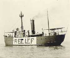
United States lightship Huron (LV-103)
1920 lightvessel, now a museum ship in Port Huron, Michigan, United States
Distance: Approx. 2669 meters
Latitude and longitude: 42.98916667,-82.42666667
The United States lightship Huron (LV-103) is a lightvessel that was launched in 1920. She is now a museum ship moored in Pine Grove Park, Port Huron, St. Clair County, Michigan.

Fort Gratiot
United States historic place
Distance: Approx. 2395 meters
Latitude and longitude: 42.995,-82.42805556
Fort Gratiot was an American stockade fort in Fort Gratiot, Michigan, in Saint Clair County, Michigan. The former location of the fort was listed on the National Register of Historic Places in 1980.
WSAQ
Radio station in Michigan, United States
Distance: Approx. 2392 meters
Latitude and longitude: 42.977,-82.464
WSAQ (107.1 FM) is a country music radio station licensed to Port Huron, Michigan, with an effective radiated power of 6,000 watts. WSAQ covers St. Clair County, Michigan and Lambton County, Ontario as well as portions of Macomb, Lapeer, and Sanilac counties.
WHLS
Radio station in Michigan, United States
Distance: Approx. 2406 meters
Latitude and longitude: 42.97694444,-82.46444444
WHLS (1450 AM) is an alternative rock radio station licensed to Port Huron, Michigan, with a power output of 1,000 watts, covering much of St. Clair County, Michigan. It is the oldest continuously operating radio station serving St.
WNFA
Radio station in Michigan, United States
Distance: Approx. 1035 meters
Latitude and longitude: 42.993,-82.468
WNFA (88.3 FM) is a Christian teaching/worship radio station in Port Huron, Michigan, United States, branded as "Bluewater Christian Hit Radio". WNFA broadcasts with 1,300 watts. WNFA formerly featured programming from the WAY-FM Network (formerly the Christian Hit Radio Satellite Network) until national distribution of WAY-FM programming (except for "The Wally Show" mornings) to non-owned stations ceased on July 1, 2013.

Fort St. Joseph (Port Huron)
Distance: Approx. 2453 meters
Latitude and longitude: 43.00193,-82.42758
Fort St. Joseph was a fort established in 1686 by Daniel Greysolon, Sieur du Lhut for New France. Erected on the St.
Port Huron Fire of 1871
Historic event
Distance: Approx. 2534 meters
Latitude and longitude: 42.98027778,-82.4375
The Port Huron Fire of October 8, 1871 (one of a series of fires known collectively as the Great Fire of 1871 or the Great Michigan Fire) burned a number of cities including White Rock and Port Huron, and much of the countryside in the "Thumb" region of the U.S. state of Michigan (a total of 1.2 million acres, or 4,850 km²). On the same day, other fires burned the cities of Holland and Manistee, Michigan, as well as broad swaths of forest in various areas of the state; the Great Chicago Fire and the Peshtigo Fire also occurred on the same day. At least 50 people died as a result of the Port Huron Fire, and at least 200 from all the fires in the state.

Port Huron–Sarnia Border Crossing
Canada–United States border crossing
Distance: Approx. 2748 meters
Latitude and longitude: 42.9987,-82.42347
The Port Huron–Sarnia Border Crossing connects the cities of Port Huron, Michigan and Sarnia, Ontario. It is located at the Blue Water Bridge at the St. Clair River.
Weather in this IP's area
scattered clouds
19 Celsius
19 Celsius
18 Celsius
19 Celsius
1012 hPa
78 %
1012 hPa
991 hPa
10000 meters
6.69 m/s
9.26 m/s
190 degree
40 %
07:10:04
17:16:48
