Country:
Region:
City:
Latitude and Longitude:
Time Zone:
Postal Code:
IP information under different IP Channel
ip-api
Country
Region
City
ASN
Time Zone
ISP
Blacklist
Proxy
Latitude
Longitude
Postal
Route
Luminati
Country
ASN
Time Zone
America/Chicago
ISP
TWC-11427-TEXAS
Latitude
Longitude
Postal
IPinfo
Country
Region
City
ASN
Time Zone
ISP
Blacklist
Proxy
Latitude
Longitude
Postal
Route
db-ip
Country
Region
City
ASN
Time Zone
ISP
Blacklist
Proxy
Latitude
Longitude
Postal
Route
ipdata
Country
Region
City
ASN
Time Zone
ISP
Blacklist
Proxy
Latitude
Longitude
Postal
Route
Popular places and events near this IP address
Houston Public Library
Public library system of Houston, Texas
Distance: Approx. 106 meters
Latitude and longitude: 29.75945,-95.36993
Houston Public Library is the public library system serving Houston, Texas, United States.

Sam Houston Coliseum
Arena in Texas, United States
Distance: Approx. 120 meters
Latitude and longitude: 29.761453,-95.369546
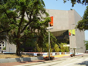
Sam Houston Coliseum was an indoor arena located in Houston, Texas.

Heritage Plaza
Skyscraper in Houston, Texas
Distance: Approx. 212 meters
Latitude and longitude: 29.75861,-95.37055
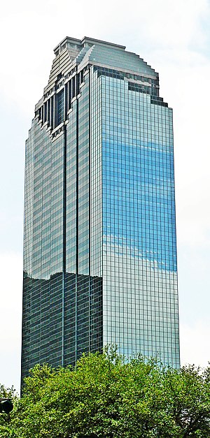
Heritage Plaza is a postmodern skyscraper located in the Skyline District of downtown Houston, Texas. Standing at 762 feet (232 m), the tower is the 5th-tallest building in Houston, the 8th-tallest in Texas, and the 60th-tallest in the United States. The building, designed by Houston-based M. Nasr & Partners P.C., was completed in 1987, and has 53 floors.

Tranquillity Park
Park in downtown Houston
Distance: Approx. 149 meters
Latitude and longitude: 29.7607,-95.3683
Tranquillity Park is a municipal park in Houston, Texas.

Hobby Center for the Performing Arts
Theater in Houston, Texas
Distance: Approx. 120 meters
Latitude and longitude: 29.761453,-95.369546
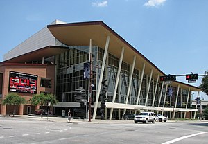
The Hobby Center for the Performing Arts is a theater in Houston, Texas, United States. Opened to the public in 2002, the theater is located downtown on the edge of the Houston Theater District. Hobby Center features 60-foot-high (18 m) glass walls with views of Houston's skyscrapers, Tranquility Park and Houston City Hall.

Houston City Hall
City hall in Houston, Texas, U.S.
Distance: Approx. 45 meters
Latitude and longitude: 29.7602,-95.3694
The Houston City Hall building is the headquarters of the City of Houston's municipal government. Constructed during 1938 and 1939, the City Hall complex is located on Bagby Street on the western side of Downtown Houston. It is surrounded by the Houston Skyline District and is similar in design to dozens of other city halls built in the southwest United States during the same time period.
Julia Ideson Building
Historic building in Houston, Texas, U.S.
Distance: Approx. 179 meters
Latitude and longitude: 29.75888889,-95.36916667
The Julia Ideson Building is a Houston Public Library facility in Downtown Houston, Texas, United States. It is named for Julia Bedford Ideson, who served as the system's first head librarian for 40 years. The Spanish Renaissance-style building is part of the Central Library, and houses its archives, manuscripts, and Texas and Local History departments.

Houston Music Hall
Defunct music hall
Distance: Approx. 120 meters
Latitude and longitude: 29.761453,-95.369546
Houston Music Hall was a 2,200-seat music venue located in Houston, Texas. The Music Hall opened in November 1937, at the same time as the Sam Houston Coliseum, which were built conjointly as the brainchild of Jesse H. Jones, and designed by Alfred C. Finn, his frequent collaborator. The project was financed by the Works Progress Administration at a cost of $1.3 million, and replaced Sam Houston Hall, which was a wooden structure that had been erected on the site for the 1928 Democratic National Convention and torn down in 1936.
Sam Houston Hall
Distance: Approx. 164 meters
Latitude and longitude: 29.76186111,-95.36998611
The Sam Houston Hall was a building in Houston, Texas. It was located at 801 Bagby Street in the Fourth Ward, though now considered a part of downtown. It was designed as a temporary structure for the 1928 Democratic National Convention.
Sweeney Clock
Clock near Tranquillity Park, Houston, Texas
Distance: Approx. 212 meters
Latitude and longitude: 29.762086,-95.368774
The Sweeney Clock is a 1908 clock installed near Houston's Tranquillity Park, in the U.S. state of Texas. The clock was originally installed outside the J.J. Sweeney & Co. jewelry store at the intersection of Main and Prairie, from 1908 to 1928.
World War I Monument
War memorial in Houston, Texas, U.S.
Distance: Approx. 202 meters
Latitude and longitude: 29.75915,-95.371318
The World War I Monument is a war memorial by an unknown creator, installed outside the Heritage Society, adjacent to Houston's Sam Houston Park, in the U.S. state of Texas. The bronze and granite memorial commemorates local soldiers who died in World War I, and features a bronze plaque depicting an eagle and displaying a list of names, set within a granite block.
Alexander Hodge Memorial
Stone memorial in Sam Houston Park, Houston, Texas, U.S.
Distance: Approx. 209 meters
Latitude and longitude: 29.75944444,-95.37166667
The Alexander Hodge Memorial is an outdoor 1908 stone monument, installed in Sam Houston Park, Houston, in the U.S. state of Texas. The memorial, dedicated in 1912, was erected by the Lady Washington Chapter of the Daughters of the American Revolution to recognize Hodge as "a hero of two republics".
Weather in this IP's area
scattered clouds
25 Celsius
25 Celsius
24 Celsius
26 Celsius
1011 hPa
68 %
1011 hPa
1009 hPa
10000 meters
6.17 m/s
9.26 m/s
150 degree
40 %
06:47:33
17:25:26


