64.6.30.33 - IP Lookup: Free IP Address Lookup, Postal Code Lookup, IP Location Lookup, IP ASN, Public IP
Country:
 USA
USARegion:
City:
Location:
Time Zone:
Postal Code:
ISP:
ASN:
language:
User-Agent:
Proxy IP:
Blacklist:
IP information under different IP Channel
ip-api
Country
Region
City
ASN
Time Zone
ISP
Blacklist
Proxy
Latitude
Longitude
Postal
Route
db-ip
Country
Region
City
ASN
Time Zone
ISP
Blacklist
Proxy
Latitude
Longitude
Postal
Route
IPinfo
Country
Region
City
ASN
Time Zone
ISP
Blacklist
Proxy
Latitude
Longitude
Postal
Route
IP2Location
64.6.30.33Country
usRegion
connecticut
City
norwalk
Time Zone
America/New_York
ISP
Language
User-Agent
Latitude
Longitude
Postal
ipdata
Country
Region
City
ASN
Time Zone
ISP
Blacklist
Proxy
Latitude
Longitude
Postal
Route
Popular places and events near this IP address

Norwalk, Connecticut
City in Connecticut, United States
Distance: Approx. 1026 meters
Latitude and longitude: 41.09388889,-73.41972222
Norwalk is a city in Fairfield County, Connecticut, United States. The city, part of the New York Metropolitan Area, is the sixth-most populous city in Connecticut as of the 2020 census, with a population of 91,184. Norwalk is on the northern shore of Long Island Sound and was first settled in 1649.

Brien McMahon High School
Public school in Norwalk, Connecticut, United States
Distance: Approx. 581 meters
Latitude and longitude: 41.08555556,-73.43333333
Brien McMahon High School (BMHS) is a secondary school located in Norwalk, Connecticut, United States. It is named after Brien McMahon, a former United States Senator from Norwalk. The school's mascot is a Senator and its colors are red, white, and blue.

Norwalk Oyster Festival
Distance: Approx. 1418 meters
Latitude and longitude: 41.0954,-73.4155
The Norwalk Oyster Festival is an annual fair in the city of Norwalk, Connecticut, United States, held on the first weekend after Labor Day in Veterans Park, near Long Island Sound. Funds raised by the festival help the Norwalk Seaport Association maintain the Sheffield Island Lighthouse as well as develop science education classes. The festival is also used as a fundraiser by more than 20 other local non-profit organizations.

South Norwalk station
Railroad station in Connecticut
Distance: Approx. 968 meters
Latitude and longitude: 41.0957,-73.42185
South Norwalk station is a commuter rail station in Norwalk, Connecticut, served by the Metro-North Railroad's New Haven Line. It is owned and managed by the Norwalk Transit District. The station is the point where the New Haven Line's Danbury Branch connects to the Northeast Corridor, as well as a peak-hour terminal for some express trains.
Washington Village (Norwalk, Connecticut)
Distance: Approx. 1343 meters
Latitude and longitude: 41.0945,-73.416
Washington Village, is a 136 unit public housing complex in the South Norwalk neighborhood of Norwalk, Connecticut, United States, in the block bound by Water Street, Raymond Street, Day Street and Concord Street. It is the oldest public housing development in Connecticut, occupied since 1941. It was designed by Frank Bissell, an architect who had moved to Norwalk after having worked in the New York offices of Barber and Bissell.

Beth Israel Synagogue (Norwalk, Connecticut)
Religious building in Norwalk, Connecticut, United States
Distance: Approx. 1041 meters
Latitude and longitude: 41.09305556,-73.41916667
Beth Israel Synagogue was an Orthodox synagogue and, since 1972, a Baptist church building located at 31 Concord Street in the South Norwalk section of Norwalk, Connecticut, in the United States. Built in 1906, the Moorish Revival style building is the only known synagogue building in Connecticut displaying Moorish onion domes, and is an unusual example of an urban wood-frame synagogue. Since 1972, the building has been owned and occupied by the Canaan Institutional Ba'ptist Church.
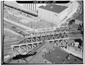
South Norwalk Railroad Bridge
Bridge
Distance: Approx. 1386 meters
Latitude and longitude: 41.09888889,-73.41888889
The South Norwalk Railroad Bridge is an 1895 bridge in Norwalk, Connecticut. It carries the four sets of Metro-North railroad tracks across the busy intersection of Main Street and Washington Street in the South Norwalk section of the city. The bridge is adjacent to the South Norwalk Switch Tower Museum, which showcases the railroad switch tower where tracks were physically switched at the intersection of the Danbury Branch and the New Haven Line.

Haviland and Elizabeth Streets–Hanford Place Historic District
Historic district in Connecticut, United States
Distance: Approx. 1270 meters
Latitude and longitude: 41.09694444,-73.41861111
The Haviland and Elizabeth Streets–Hanford Place Historic District is an irregularly shaped 4.3-acre (1.7 ha) historic district in Norwalk, Connecticut that was listed on the National Register of Historic Places in 1988. It encompasses a neighborhood that developed in the late 19th century following the introduction of railroad service to South Norwalk.

United States Post Office–South Norwalk Main
United States historic place
Distance: Approx. 1239 meters
Latitude and longitude: 41.09888889,-73.42138889
The US Post Office–South Norwalk Main, also known as Norwalk Main Post Office, is located at 16 Washington Street in Norwalk, Connecticut. It is a single story steel and concrete structure, faced in limestone. It was designed in 1936 and built in 1937, and is an example of what has been termed "starved classicism".
Saint Joseph Church (Norwalk, Connecticut)
Church in Connecticut, United States
Distance: Approx. 1171 meters
Latitude and longitude: 41.095375,-73.41873056
St. Joseph is a Roman Catholic church in South Norwalk, Connecticut, part of the Diocese of Bridgeport.
St. Ladislaus Church (South Norwalk, Connecticut)
Church in Connecticut, United States
Distance: Approx. 385 meters
Latitude and longitude: 41.0929,-73.4278
St.Ladislaus is a Roman Catholic church in South Norwalk, Connecticut, part of the Diocese of Bridgeport.

SONO 50
Office building in Norwalk, Connecticut
Distance: Approx. 1256 meters
Latitude and longitude: 41.0994,-73.4219
SONO 50 (also known as the SoNo Corporate Center) is an office building in Norwalk, Connecticut in the modernist style. It is the tallest building in Norwalk, standing 14 stories and 150 feet (46 m) tall.
Weather in this IP's area
broken clouds
-2 Celsius
-5 Celsius
-4 Celsius
-1 Celsius
1021 hPa
91 %
1021 hPa
1014 hPa
10000 meters
1.78 m/s
2.59 m/s
245 degree
81 %