64.58.251.150 - IP Lookup: Free IP Address Lookup, Postal Code Lookup, IP Location Lookup, IP ASN, Public IP
Country:
 USA
USARegion:
City:
Location:
Time Zone:
Postal Code:
ISP:
ASN:
language:
User-Agent:
Proxy IP:
Blacklist:
IP information under different IP Channel
ip-api
Country
Region
City
ASN
Time Zone
ISP
Blacklist
Proxy
Latitude
Longitude
Postal
Route
db-ip
Country
Region
City
ASN
Time Zone
ISP
Blacklist
Proxy
Latitude
Longitude
Postal
Route
IPinfo
Country
Region
City
ASN
Time Zone
ISP
Blacklist
Proxy
Latitude
Longitude
Postal
Route
IP2Location
64.58.251.150Country
usRegion
pennsylvania
City
homestead
Time Zone
America/New_York
ISP
Language
User-Agent
Latitude
Longitude
Postal
ipdata
Country
Region
City
ASN
Time Zone
ISP
Blacklist
Proxy
Latitude
Longitude
Postal
Route
Popular places and events near this IP address

Homestead, Pennsylvania
Borough in Pennsylvania, United States
Distance: Approx. 1475 meters
Latitude and longitude: 40.40611111,-79.91222222
Homestead is a borough in Allegheny County, Pennsylvania, United States, along the Monongahela River 7 miles (11 km) southeast of downtown Pittsburgh. The borough is known for the Homestead strike of 1892, an important event in the history of labor relations in the United States. The population was 2,884 at the 2020 census.

Munhall, Pennsylvania
Borough in Pennsylvania, United States
Distance: Approx. 440 meters
Latitude and longitude: 40.39120278,-79.90122222
Munhall is a borough in Allegheny County, Pennsylvania, United States, on the west bank of the Monongahela River. The population was 10,774 at the 2020 census. It is a residential suburb of the Pittsburgh metropolitan area.

West Homestead, Pennsylvania
Borough in Pennsylvania, United States
Distance: Approx. 906 meters
Latitude and longitude: 40.39444444,-79.91527778
West Homestead is a borough in Allegheny County, Pennsylvania, United States, 8 miles (13 km) southeast of Pittsburgh, on the Monongahela River. Heavy industries associated with nearby steel mills existed here, such as axle works, brickworks, and manufactories of machinery, car wheels, etc. The largest concern was Mesta Machinery, which was one of the world's leading industrial manufacturers from 1898 until 1983.

Whitaker, Pennsylvania
Borough in Pennsylvania, United States
Distance: Approx. 1629 meters
Latitude and longitude: 40.39944444,-79.88666667
Whitaker is a borough in Allegheny County, Pennsylvania, United States, and is on the Monongahela River 3 miles (5 km) upriver from Pittsburgh. The population was 1,179 at the 2020 census. The borough is named for James Whitaker, a pioneer settler.

The Waterfront
Shopping mall in Homestead, West Homestead and Munhall
Distance: Approx. 1962 meters
Latitude and longitude: 40.41111111,-79.91111111
The Waterfront is a super-regional open air shopping mall spanning the three boroughs of Homestead, West Homestead, and Munhall near Pittsburgh. The shopping mall sits on land once occupied by U.S. Steel's Homestead Steel Works plant, which closed in 1986. It has a gross leasable area of 700,000 square feet (65,000 m2) in "The Waterfront" and 400,000 square feet (37,000 m2) in "The Town Center." The development officially opened in 1999.
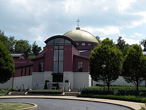
St. John the Baptist Byzantine Catholic Cathedral (Pittsburgh)
Ruthenian Greek Catholic cathedral in the US
Distance: Approx. 1624 meters
Latitude and longitude: 40.3821,-79.9153
St. John the Baptist Byzantine Catholic Cathedral is the mother church of Ruthenian Greek Catholic Church. It is located at 210 Greentree Road in Munhall, Pennsylvania, a suburb of Pittsburgh in the Monongahela River valley.
Bost Building
United States historic place
Distance: Approx. 1650 meters
Latitude and longitude: 40.40901944,-79.90446111
The Bost Building, also known as Columbia Hotel, is located on East Eighth Avenue (PA 837) in Homestead, Pennsylvania, United States. Built just before the 1892 Homestead Strike, it was used as headquarters by the Amalgamated Association of Iron and Steel Workers and for reporters covering the confrontation. It is the only significant building associated with the strike that remains intact.
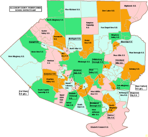
Steel Valley School District
School district in Pennsylvania
Distance: Approx. 704 meters
Latitude and longitude: 40.40029,-79.90236
The Steel Valley School District is a small, suburban public school district in the state of Pennsylvania. It is located to the southeast of the city of Pittsburgh. It serves the boroughs of Homestead, Munhall, and West Homestead, former mill towns.
Carnegie Library of Homestead
Public library with a music hall in Munhall, Pennsylvania
Distance: Approx. 1440 meters
Latitude and longitude: 40.40708056,-79.90297778
The Carnegie Library of Homestead is a public library in Munhall, Pennsylvania founded by Andrew Carnegie in 1898. It is one of 2,509 Carnegie libraries worldwide, 1,689 of which were built in the United States. It was the sixth library commissioned by Carnegie in the U.S. and the seventh to open.1 Completed in November 1898, it is the third oldest Carnegie library in continuous operation in its original structure in the U.S. after the Main Branch and Lawrenceville Branch of Pittsburgh.2 The library is an independent entity; it is not a "branch" of the Carnegie Library of Pittsburgh, which operates one main facility and 19 branches within the city of Pittsburgh.
Homestead Historic District
Historic district in Pennsylvania, United States
Distance: Approx. 1197 meters
Latitude and longitude: 40.40472222,-79.9075
The Homestead Historic District is a historic district which is located in Homestead, Munhall, and West Homestead, Pennsylvania. It was listed on the National Register of Historic Places (NRHP) in 1990.

Homestead station
Distance: Approx. 1701 meters
Latitude and longitude: 40.40805556,-79.91305556
Homestead is a former railway station which is located in Homestead, Pennsylvania. It is now used by the Allegheny County District Attorney's office as a support and training facility.

St Nicholas Carpatho-Rusyn church
Church in Pennsylvania, United States
Distance: Approx. 1519 meters
Latitude and longitude: 40.407093,-79.91048
St. Nicholas Orthodox Church, also known as St. Nicholas Carpatho-Russian Orthodox Church, is a historic Russian Orthodox church at 903 Ann Street in Homestead, Pennsylvania.
Weather in this IP's area
mist
5 Celsius
1 Celsius
3 Celsius
7 Celsius
1009 hPa
94 %
1009 hPa
970 hPa
9656 meters
7.72 m/s
11.32 m/s
330 degree
100 %