Country:
 USA
USARegion:
City:
Latitude and Longitude:
Time Zone:
Postal Code:
IP information under different IP Channel
ip-api
Country
Region
City
ASN
Time Zone
ISP
Blacklist
Proxy
Latitude
Longitude
Postal
Route
IPinfo
Country
Region
City
ASN
Time Zone
ISP
Blacklist
Proxy
Latitude
Longitude
Postal
Route
MaxMind
Country
Region
City
ASN
Time Zone
ISP
Blacklist
Proxy
Latitude
Longitude
Postal
Route
Luminati
Country
USASN
Time Zone
America/Chicago
ISP
INTERNET2-I2PX
Latitude
Longitude
Postal
db-ip
Country
Region
City
ASN
Time Zone
ISP
Blacklist
Proxy
Latitude
Longitude
Postal
Route
ipdata
Country
Region
City
ASN
Time Zone
ISP
Blacklist
Proxy
Latitude
Longitude
Postal
Route
Popular places and events near this IP address

University of Michigan College of Engineering
Engineering school of the University of Michigan
Distance: Approx. 2073 meters
Latitude and longitude: 42.29222222,-83.71388889
The University of Michigan College of Engineering (branded as Michigan Engineering) is the engineering college of the University of Michigan, a public research university in Ann Arbor, Michigan.
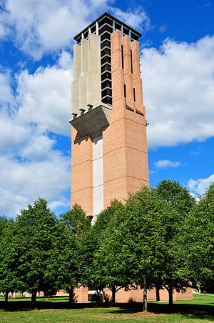
Lurie Tower
Bell tower in Ann Arbor, Michigan, US
Distance: Approx. 2252 meters
Latitude and longitude: 42.29197222,-83.71613889
The Ann and Robert H. Lurie Tower, a memorial built in 1996 for Michigan alumnus Robert H. Lurie, is located on North Campus at the University of Michigan in Ann Arbor. It houses a 60-bell grand carillon, one of the university's two grand carillons; the other is housed in Burton Tower on Central Campus. These are two of only 23 grand carillons in the world.

Matthaei Botanical Gardens
Botanical garden
Distance: Approx. 2255 meters
Latitude and longitude: 42.30116667,-83.66402778
The University of Michigan Matthaei Botanical Gardens (300 acres, 121 hectares) includes botanical gardens, natural areas with trails, and several research-quality habitats and is part of the organization Matthaei Botanical Gardens and Nichols Arboretum. It was established in 1907. The botanical gardens includes outdoor display gardens, the Gaffield Children's Garden, a 10,000+ square-foot conservatory, and natural areas with walking trails.

Gerald R. Ford Presidential Library
Presidential library for U.S. President Gerald Ford, located in Ann Arbor, Michigan
Distance: Approx. 2247 meters
Latitude and longitude: 42.28781,-83.712516
The Gerald R. Ford Presidential Library is a repository located on the north campus of the University of Michigan in Ann Arbor. The library houses archival materials on the life, career, and presidency of Gerald Ford, the 38th president of the United States. The Gerald R. Ford Presidential Library is a part of the National Archives and Records Administrations presidential library system.

Lurie Biomedical Engineering Center
Distance: Approx. 2245 meters
Latitude and longitude: 42.28880556,-83.71352222
The Ann and Robert H. Lurie Biomedical Engineering Building officially opened in August 2006. It was part of an expansion of the University of Michigan Biomedical Engineering Department (BME). The building houses researchers previously spread through several different University of Michigan campus locations.
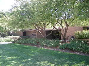
Bentley Historical Library
Library at the University of Michigan
Distance: Approx. 2134 meters
Latitude and longitude: 42.289425,-83.71245556
The Bentley Historical Library is the campus archive for the University of Michigan and is located on the University of Michigan's North Campus in Ann Arbor. It was established in 1935 by the regents of the University of Michigan. Its mission is to serve as the official archives of the university and to document the history of the state of Michigan, as well as the activities of its people, organizations and voluntary associations.
Ford Nuclear Reactor
Decommissioned nuclear reactor at the University of Michigan
Distance: Approx. 2205 meters
Latitude and longitude: 42.29086111,-83.71472222
The Ford Nuclear Reactor was a facility at the University of Michigan in Ann Arbor dedicated to investigating the peaceful uses of nuclear power. It was a part of the Michigan Memorial Phoenix Project, a living memorial created to honor the casualties of World War II. The reactor operated from September 1957 until July 3, 2003. During its operation, the FNR was used to study medicine, cellular biology, chemistry, physics, mineralogy, archeology, anthropology, and nuclear science.
Neutron Science Laboratory
Distance: Approx. 1656 meters
Latitude and longitude: 42.293461,-83.709041
The Neutron Science Laboratory (NSL) is situated within the North Campus of the University of Michigan and houses various neutron and gamma-ray sources and a range of nuclear radiation detection equipment. The laboratory is an integral part of Nuclear Engineering and Radiological Sciences (NERS) department at the University of Michigan (U-M) and is managed by the Applied Nuclear Science Group. The laboratory was renovated in 2017 with a specific goal to accommodate the use of a new DT neutron generator (Thermo Fisher Scientific, Model P211) in various open-beam configurations.
Father Gabriel Richard High School (Ann Arbor, Michigan)
Private, coeducational school in Ann Arbor, , Michigan, United States
Distance: Approx. 1992 meters
Latitude and longitude: 42.31394167,-83.675275
Father Gabriel Richard High School is a private, Roman Catholic high school in Ann Arbor Township near Ann Arbor, Michigan. It is located in the Roman Catholic Diocese of Lansing, and was established in 1868 by Father Patrick O'Kelly. It was originally named St.
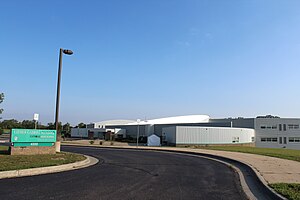
Mcity
Distance: Approx. 554 meters
Latitude and longitude: 42.300688,-83.698129
Mcity is a 32-acre (13 ha) mock city and proving ground built for the testing of wirelessly connected and driverless cars located on the University of Michigan North Campus in Ann Arbor, Michigan. The project, which officially opened on July 20, 2015, is built on land purchased by the university from a former Pfizer facility. It cost US$10 million and will be collaboratively managed by Mcity (formerly the Mobility Transformation Center - MTC).
Michigan Islamic Academy
School
Distance: Approx. 1915 meters
Latitude and longitude: 42.30130556,-83.71463889
Michigan Islamic Academy (MIA) is a Kindergarten through grade 12 Islamic private day school in Ann Arbor, Michigan. The school was opened in 1985. As of 2015 it had 213 students.

Arnold and Gertrude Goss House
United States historic place
Distance: Approx. 1277 meters
Latitude and longitude: 42.29055556,-83.69888889
The Arnold and Gertrude Goss House is a single-family home located at 3215 W. Dobson Place in Ann Arbor, Michigan. It was listed on the National Register of Historic Places in 2008.
Weather in this IP's area
clear sky
26 Celsius
26 Celsius
25 Celsius
28 Celsius
1021 hPa
42 %
1021 hPa
990 hPa
10000 meters
5.66 m/s
100 degree
07:16:21
19:42:44