64.57.108.26 - IP Lookup: Free IP Address Lookup, Postal Code Lookup, IP Location Lookup, IP ASN, Public IP
Country:
Region:
City:
Location:
Time Zone:
Postal Code:
ISP:
ASN:
language:
User-Agent:
Proxy IP:
Blacklist:
IP information under different IP Channel
ip-api
Country
Region
City
ASN
Time Zone
ISP
Blacklist
Proxy
Latitude
Longitude
Postal
Route
db-ip
Country
Region
City
ASN
Time Zone
ISP
Blacklist
Proxy
Latitude
Longitude
Postal
Route
IPinfo
Country
Region
City
ASN
Time Zone
ISP
Blacklist
Proxy
Latitude
Longitude
Postal
Route
IP2Location
64.57.108.26Country
Region
california
City
chico
Time Zone
America/Los_Angeles
ISP
Language
User-Agent
Latitude
Longitude
Postal
ipdata
Country
Region
City
ASN
Time Zone
ISP
Blacklist
Proxy
Latitude
Longitude
Postal
Route
Popular places and events near this IP address
California State University, Chico
Public university in Chico, California
Distance: Approx. 862 meters
Latitude and longitude: 39.73,-121.8475
California State University, Chico (Chico State) is a public university in Chico, California. It was founded in 1887 as one of about 180 "normal schools" founded by state governments in the 19th century to train teachers for the rapidly growing public common schools. Some closed but most steadily expanded their role and became state colleges in the early 20th century and state universities in the late 20th century.

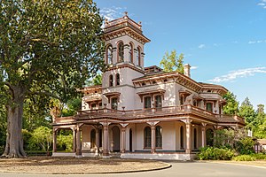
Bidwell Mansion State Historic Park
Historic building in Chico, California, United States
Distance: Approx. 654 meters
Latitude and longitude: 39.73235278,-121.84348056
Bidwell Mansion State Historic Park was a historic building with surrounding land in Chico, California, United States. It is listed as a California Historical Landmark #329 under the name "Rancho Chico And Bidwell Adobe" in 1939; and is listed on the National Register of Historic Places under the name "Bidwell Mansion" on March 24, 1972. On December 11, 2024, the building was destroyed in a fire.

Chico Senior High School
Public high school in Chico, California, United States
Distance: Approx. 1025 meters
Latitude and longitude: 39.73583333,-121.845
Chico High School is a four-year comprehensive public high school located in Chico, California, United States. As of 2017, Chico High School has 2,083 students. Founded in 1902, it predominantly serves as the public school for graduates of Chico Junior High School.
Pioneer Days (Chico, California)
Distance: Approx. 116 meters
Latitude and longitude: 39.7283,-121.8389
Pioneer Days is the historical name of an annual community event in Chico, California celebrated the week prior to Pioneer Day, the first Saturday in May. Chico has a history of "May Day Parades" dating back to the late 19th century. In 1915, the first parade that would later come to be called the Pioneer Day Parade was held on the downtown streets of Chico as a celebration of Chico Normal School's Senior Day.

Silberstein Park Building
United States historic place
Distance: Approx. 72 meters
Latitude and longitude: 39.72805556,-121.83805556
The Silberstein Park Building is a building in downtown Chico, California located across from Chico's City Plaza. It was listed on the National Register of Historic Places in 1983. It is a three-story two-part commercial block building with facade of white terra cotta brick.

Chico Midtown Station
United States historic post office
Distance: Approx. 131 meters
Latitude and longitude: 39.72768,-121.83855
The Chico Midtown Station (more commonly known as the Downtown Chico Post Office) is a United States Postal Service post office in downtown Chico, California. The building is listed on the National Register of Historic Places. It was designed in Renaissance Revival style by J.W. Roberts and Oscar Wenderoth.

South Campus Neighborhood
United States historic place
Distance: Approx. 445 meters
Latitude and longitude: 39.72611111,-121.84166667
The South Campus Historic District is a historic district in Chico, California which was named to the National Register of Historic Places in 1991 through efforts of the Chico Heritage Association. The district is situated entirely within the South Campus Neighborhood. The historical district extends from Salem Street to Cherry Street, and from West Second Street to West Sixth Street.

A. H. Chapman House
Historic house in California, United States
Distance: Approx. 764 meters
Latitude and longitude: 39.725,-121.83
The A. H. Chapman House at 256 E. 12th St. in Chico, California was built in 1859. It has also been known as "Little Chapman Mansion".

St. Augustine of Canterbury Anglican Church
Historic church in California, United States
Distance: Approx. 231 meters
Latitude and longitude: 39.72888889,-121.84027778
St. Augustine of Canterbury Anglican Church (formerly St. John's Episcopal Church) is a historic church at 230 Salem Street in the South Campus Neighborhood of Chico, California, United States.

Alfred E. Warren House
Building in Chico, California
Distance: Approx. 791 meters
Latitude and longitude: 39.730997,-121.846299
The Alfred E. Warren House, also known as President's Mansion, is the official residence of the President of California State University, Chico, located in Chico, California. Designed in 1922 by famed Californian architect Julia Morgan as a private residence, it has served as the university's presidential residence since 1945.
El Dorado Ranch
Building in Fullerton, California
Distance: Approx. 791 meters
Latitude and longitude: 39.730997,-121.846299
El Dorado Ranch, previously known as the Chapman House, is the official residence of the President of California State University, Fullerton, located in Fullerton, California.

Janet Turner Print Museum
Art Museum in California, US
Distance: Approx. 464 meters
Latitude and longitude: 39.729,-121.843
The Janet Turner Print Museum is an art museum on the campus of California State University Chico, California, United States. The museum first opened in 1981 to house the print collection of Janet E.Turner (1914–1988) an American artist and printmaker. Janet E. Turner's prints and paintings have been exhibited internationally in over 200 exhibitions in more than 50 countries.
Weather in this IP's area
clear sky
8 Celsius
7 Celsius
8 Celsius
8 Celsius
1020 hPa
49 %
1020 hPa
1010 hPa
10000 meters
1.74 m/s
1.37 m/s
59 degree
3 %