Country:
 Canada
Region:
City:
Latitude and Longitude:
Time Zone:
Postal Code:
IP information under different IP Channel
ip-api
Country
Region
City
ASN
Time Zone
ISP
Blacklist
Proxy
Latitude
Longitude
Postal
Route
IPinfo
Country
Region
City
ASN
Time Zone
ISP
Blacklist
Proxy
Latitude
Longitude
Postal
Route
MaxMind
Country
Region
City
ASN
Time Zone
ISP
Blacklist
Proxy
Latitude
Longitude
Postal
Route
Luminati
Country
CARegion
ab
City
camrose
ASN
Time Zone
America/Edmonton
ISP
ASN-WIBAND-1
Latitude
Longitude
Postal
db-ip
Country
Region
City
ASN
Time Zone
ISP
Blacklist
Proxy
Latitude
Longitude
Postal
Route
ipdata
Country
Region
City
ASN
Time Zone
ISP
Blacklist
Proxy
Latitude
Longitude
Postal
Route
Popular places and events near this IP address
CHED (AM)
Radio station in Edmonton, Alberta
Distance: Approx. 2230 meters
Latitude and longitude: 53.49055556,-113.44861111
CHED (630 kHz) is a radio station licensed to Edmonton, Alberta. Owned by Corus Entertainment, it broadcasts a news/talk format, and first signed on in 1954. Its studios are located on 84th Street and Roper Road in Edmonton, while its transmitters are located in Southeast Edmonton.
King's University (Canada)
Private Christian university in Edmonton, Canada
Distance: Approx. 2213 meters
Latitude and longitude: 53.52527778,-113.4175
The King's University in Edmonton, Alberta, Canada, is a Canadian Christian university offering bachelor's degrees in the arts, humanities, music, social sciences, natural sciences, business, and education. King's is one of 26 publicly funded post-secondary institutions in Alberta. The university serves more than 900 students from across Canada and abroad, representing more than 16 nations.
CHFA-FM
Ici Radio-Canada Première station in Edmonton
Distance: Approx. 2067 meters
Latitude and longitude: 53.523,-113.442
CHFA-FM is a Canadian radio station, which broadcasts the programming of Radio-Canada's Ici Radio-Canada Première network in Edmonton, Alberta. The station was launched in 1949 by a local non-profit consortium to bring French radio service to Edmonton, and was directly acquired by the network in 1974. The station serves the entire province of Alberta from its studios in Edmonton, although it also maintains a smaller bureau in Calgary.

W.P. Wagner High School
10-12 school in Edmonton, Alberta (est. 1969)
Distance: Approx. 1701 meters
Latitude and longitude: 53.49972222,-113.45111111
W.P. Wagner is an Edmonton Public high school located in Southeast Edmonton with a student population of about 1500. Its primary focus is science and technology. The school is named after William Phillip Wagner, a former Superintendent of Edmonton Public Schools.
Mineral Core Research Facility
Distance: Approx. 1061 meters
Latitude and longitude: 53.5032,-113.4129
The Mineral Core Research Facility (MCRF), run by the Alberta Geological Survey (AGS), assists the Alberta government's Department of Energy in administering the Metallic and Industrial Minerals Regulations of the Mines and Minerals Act for the Province of Alberta. Under these regulations, the Crown collects mineral core and rock samples from companies working on mineral permits and makes these materials publicly available for use by prospectors, mineral exploration companies and academia for mineral exploration and research purposes. The MCRF is a large warehouse complex for core storage with two viewing/display areas and a visitors office.

Provincial Archives of Alberta
Official archives of Alberta, Canada
Distance: Approx. 2642 meters
Latitude and longitude: 53.487409,-113.451929
The Provincial Archives of Alberta is the official archives of the Canadian province of Alberta. It preserves and makes available for research both private and government records of all media related to Alberta. The Provincial Archives of Alberta also serves as the permanent archival repository of the Government of Alberta.
Argyll Velodrome
Distance: Approx. 2303 meters
Latitude and longitude: 53.50732,-113.462749
The Argyll Velodrome is an outdoor velodrome in Edmonton, Alberta, Canada. The velodrome is 333.333 m (1,093.61 ft) x 7 m (23 ft) wide with a 37 degree banked concrete surface.
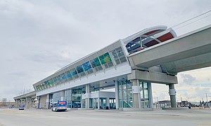
Davies station
Light rail station in Edmonton, Alberta, Canada
Distance: Approx. 1286 meters
Latitude and longitude: 53.5,-113.44416667
Davies station is an elevated light rail transit station in Edmonton, Alberta, as part of its Valley Line extension. It is located south-west of the intersection of 75 Street and Wagner Road, in Davies Industrial. The station is the first elevated rail station utilized by the Edmonton Transit Service, and includes a 1,300 stall park and ride and a new transit centre.

Avonmore stop
Light rail station in Edmonton, Alberta, Canada
Distance: Approx. 1819 meters
Latitude and longitude: 53.50944444,-113.455
Avonmore stop is a tram stop in the Edmonton LRT network in Edmonton, Alberta, Canada. It serves the Valley Line, and is located on 83 Street, staggered on either side of 73 Avenue, in Avonmore. Northbound passengers board the train north of 73 Avenue, while southbound passengers board south of 73 Avenue.

Bonnie Doon stop
Light rail station in Edmonton, Alberta, Canada
Distance: Approx. 2331 meters
Latitude and longitude: 53.51944444,-113.45555556
Bonnie Doon stop is a tram stop on the Edmonton LRT network in Edmonton, Alberta, Canada. It serves the Valley Line, and is located on the west side of 83 Street, south of 84 Avenue, between Bonnie Doon and Idylwylde. The stop was scheduled to open in 2020; however, it opened on November 4, 2023.

Simona Maaskant Library
Library in Edmonton
Distance: Approx. 2213 meters
Latitude and longitude: 53.52527778,-113.4175
The Simona Maaskant Library is the library at the King's University in Edmonton, first opened in 1981 as The King's College Library, and renamed in 1998 after its chief librarian Simona Maaskant.

Gerry Wright Operations and Maintenance Facility
Maintenance facility in Edmonton, Alberta, Canada
Distance: Approx. 2312 meters
Latitude and longitude: 53.48666667,-113.43888889
The Gerry Wright Operations and Maintenance Facility (OMF) is the maintenance facility, garage, and operations centre for the light rail transit Valley Line, in the city of Edmonton, Alberta. Located in the Roper industrial area, on the north side of Whitemud Drive, it has housed the light rail vehicles for the Valley Line since 2018.
Weather in this IP's area
scattered clouds
15 Celsius
14 Celsius
13 Celsius
16 Celsius
1007 hPa
55 %
1007 hPa
931 hPa
10000 meters
4.02 m/s
8.05 m/s
265 degree
31 %
07:15:18
19:39:23