Country:
 Canada
Region:
City:
Latitude and Longitude:
Time Zone:
Postal Code:
IP information under different IP Channel
ip-api
Country
Region
City
ASN
Time Zone
ISP
Blacklist
Proxy
Latitude
Longitude
Postal
Route
IPinfo
Country
Region
City
ASN
Time Zone
ISP
Blacklist
Proxy
Latitude
Longitude
Postal
Route
MaxMind
Country
Region
City
ASN
Time Zone
ISP
Blacklist
Proxy
Latitude
Longitude
Postal
Route
Luminati
Country
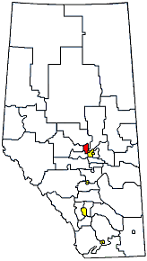
CARegion
ab
City
camrose
ASN
Time Zone
America/Edmonton
ISP
ASN-WIBAND-1
Latitude
Longitude
Postal
db-ip
Country
Region
City
ASN
Time Zone
ISP
Blacklist
Proxy
Latitude
Longitude
Postal
Route
ipdata
Country
Region
City
ASN
Time Zone
ISP
Blacklist
Proxy
Latitude
Longitude
Postal
Route
Popular places and events near this IP address
CFRN-DT
CTV television station in Edmonton
Distance: Approx. 3195 meters
Latitude and longitude: 53.54180556,-113.64138889
CFRN-DT (channel 3) is a television station in Edmonton, Alberta, Canada, part of the CTV Television Network. It is owned and operated by network parent Bell Media alongside cable-exclusive CTV 2 Alberta. The two outlets share studios with sister radio station CFRN (1260 AM) on Stony Plain Road in Edmonton; CFRN-DT's transmitter is located near Highway 21, southeast of Sherwood Park.
Spruce Grove-Sturgeon-St. Albert
Defunct provincial electoral district in Alberta, Canada
Distance: Approx. 3833 meters
Latitude and longitude: 53.59,-113.71
Spruce Grove-Sturgeon-St. Albert was a provincial electoral district in Alberta, Canada mandated to return a single member to the Legislative Assembly of Alberta using the first-past-the-post method of voting from 1993 to 2012.

Edmonton-Meadowlark
Defunct provincial electoral district in Alberta, Canada
Distance: Approx. 3049 meters
Latitude and longitude: 53.54,-113.65
Edmonton Meadowlark was a provincial electoral district in Alberta, Canada, mandated to return a single member to the Legislative Assembly of Alberta using the first past the post method of voting from 1971 to 2019. The electoral district located on the western edge of Edmonton was created in the 1971 boundary redistribution from the old electoral districts of Edmonton Jasper Place and Edmonton West. The district has switched support between Progressive Conservative and Liberal candidates with regular frequency since it was created, a trend broken by the election of the New Democrat MLA Jon Carson in the 2015 general election.
Terra Losa, Edmonton
Neighbourhood in Edmonton, Alberta, Canada
Distance: Approx. 4618 meters
Latitude and longitude: 53.535,-113.622
Terra Losa is a mixed residential and commercial neighbourhood located in west Edmonton, Alberta, Canada. It is bounded on the east by 170 Street, on the south by 95 Avenue, on the west by 178 Street, and on the north by 100 Avenue (west of 176 Street) and 99A Avenue (east of 176 Street).

Lois Hole Centennial Provincial Park
Provincial park in Alberta, Canada
Distance: Approx. 4115 meters
Latitude and longitude: 53.59638889,-113.70222222
Lois Hole Centennial Provincial Park is a provincial park and part of a designated Important Bird Area in Alberta, Canada, located immediately west from Edmonton and St. Albert. It was named after Lois Hole, former Lieutenant Governor of Alberta.
Big Lake (Alberta)
Eutrophic lake in near Edmonton, Alberta
Distance: Approx. 4697 meters
Latitude and longitude: 53.59722222,-113.71583333
Big Lake is a lake in Edmonton metropolitan region, Canada. It is located adjacent to the northwest corner of Edmonton and the southwest corner of St. Albert.
Trumpeter, Edmonton
Neighbourhood in Edmonton, Alberta, Canada
Distance: Approx. 2784 meters
Latitude and longitude: 53.589,-113.677
Trumpeter is a neighbourhood in northwest Edmonton, Alberta, Canada that was established in 2008 through the adoption of the Big Lake Neighbourhood One Neighbourhood Structure Plan (NSP). It is located within the Big Lake area and was originally considered Neighbourhood 1 within the Big Lake Area Structure Plan (ASP). It was officially named Trumpeter on August 19, 2009.
Yellowhead Tribal College
Educational institution in Edmonton
Distance: Approx. 3816 meters
Latitude and longitude: 53.5491,-113.6198
Yellowhead Tribal College is an educational institution located in Edmonton, Alberta, Canada, which is run by four member nations of Treaty 6 with the four members being Alexander First Nation, O'Chiese First Nation, Sunchild First Nation and Alexis Nakota Sioux Nation. Yellowhead Tribal College is an inclusive and open learning institution that welcomes all adult learners.
Springwater School
Distance: Approx. 3619 meters
Latitude and longitude: 53.5889,-113.7072
Springwater School was built in 1922 and is located in Starland County, 10 miles north of the Michichi turn off on Highway 9 in Alberta, Canada. The School was part of the Drumheller School Division No. 30.
Kinglet Gardens, Edmonton
Neighbourhood in Edmonton, Alberta, Canada
Distance: Approx. 2448 meters
Latitude and longitude: 53.579,-113.699
Kinglet Gardens is a developing neighborhood in northwest Edmonton, Alberta, Canada. It was named for golden-crowned kinglets and ruby-crowned kinglets that are native to nearby Big Lake. Kinglet Gardens is located within the Big Lake area and is identified as Neighbourhood 4 within the Big Lake Area Structure Plan (ASP).
Pintail Landing, Edmonton
Neighbourhood in Edmonton, Alberta, Canada
Distance: Approx. 1783 meters
Latitude and longitude: 53.58,-113.676
Pintail Landing is a future neighbourhood in northwest Edmonton, Alberta, Canada. It was named for northern pintail ducks that are native to nearby Big Lake. Pintail Landing is located within the Big Lake area and is identified as Neighbourhood 5 within the Big Lake Area Structure Plan (ASP).
Cannell, Alberta
Industrial area in Edmonton, Alberta, Canada
Distance: Approx. 4915 meters
Latitude and longitude: 53.596,-113.62
Cannell is an industrial area within the Mistatim Industrial neighbourhood in Edmonton, Alberta, Canada. Cannell was formerly an unincorporated area in Parkland County, until the 1982 Edmonton general annexation. The community has the name of William Cannell, a businessperson in the local brick industry.
Weather in this IP's area
clear sky
13 Celsius
12 Celsius
12 Celsius
14 Celsius
1008 hPa
61 %
1008 hPa
929 hPa
10000 meters
4.12 m/s
290 degree
07:16:15
19:40:23