Country:
 Canada
Region:
City:
Latitude and Longitude:
Time Zone:
Postal Code:
IP information under different IP Channel
ip-api
Country
Region
City
ASN
Time Zone
ISP
Blacklist
Proxy
Latitude
Longitude
Postal
Route
IPinfo
Country
Region
City
ASN
Time Zone
ISP
Blacklist
Proxy
Latitude
Longitude
Postal
Route
MaxMind
Country
Region
City
ASN
Time Zone
ISP
Blacklist
Proxy
Latitude
Longitude
Postal
Route
Luminati
Country
CARegion
mb
City
winnipeg
ASN
Time Zone
America/Winnipeg
ISP
ASN-WIBAND-1
Latitude
Longitude
Postal
db-ip
Country
Region
City
ASN
Time Zone
ISP
Blacklist
Proxy
Latitude
Longitude
Postal
Route
ipdata
Country
Region
City
ASN
Time Zone
ISP
Blacklist
Proxy
Latitude
Longitude
Postal
Route
Popular places and events near this IP address

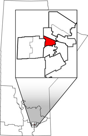
Minto (electoral district)
Defunct provincial electoral district in Manitoba, Canada
Distance: Approx. 646 meters
Latitude and longitude: 49.894,-97.179
Minto was a provincial electoral division in the Canadian province of Manitoba. It was created by redistribution in 1999, and has formally existed since the provincial election of 1999. The riding is located in the centre of the City of Winnipeg.
Happyland Park
Amusement park in Winnipeg, Canada (1906–1922)
Distance: Approx. 753 meters
Latitude and longitude: 49.88166667,-97.17666667
Happyland Park was an amusement park in Winnipeg, Manitoba, Canada. Construction started on May 1, 1906, on 13 hectares (32 acres) of land between Aubrey and Dominion streets. Portage Avenue bounded it to the north and the Assiniboine River was to the south.
Sherburn Park
Baseball stadium in Winnipeg, Canada (1924–1942)
Distance: Approx. 475 meters
Latitude and longitude: 49.88452778,-97.17602778
Sherburn Park was a baseball stadium in Winnipeg, Manitoba, located at the corner of Sherburn Street at Portage Avenue, on the very same site as the former Happyland Park. It was the second home of the Winnipeg Maroons of the Northern League. It had a seating capacity of 3,500.
Royal Winnipeg Rifles
Military unit
Distance: Approx. 282 meters
Latitude and longitude: 49.8907,-97.1788
The Royal Winnipeg Rifles (R Wpg Rif) are a Primary Reserve one-battalion infantry regiment of the Canadian Army. Nicknamed the "Little Black Devils", they are based at Minto Armoury in Winnipeg, Manitoba. The Royal Winnipeg Rifles are part of 3rd Canadian Division's 38 Canadian Brigade Group.

Wolseley, Winnipeg
Place in Manitoba, Canada
Distance: Approx. 828 meters
Latitude and longitude: 49.88166667,-97.17388889
Wolseley is a neighbourhood located within the West End of Winnipeg, Manitoba. It is named for field marshal Sir Garnet Wolseley, a British Army officer who came to Manitoba in 1870 to suppress the Red River Rebellion. It is affectionately known as "The Granola Belt" of Winnipeg.
Winnipeg Velodrome
Distance: Approx. 1108 meters
Latitude and longitude: 49.88694444,-97.19472222
The Winnipeg Velodrome was a cycling facility built in Winnipeg, Manitoba for the 1967 Pan-American Games and managed by Winnipeg Enterprises. The facility was a banked short-track oval with a cement surface. The velodrome was located near the Winnipeg Arena and Winnipeg Stadium.

West End, Winnipeg
Urban area in Manitoba, Canada
Distance: Approx. 890 meters
Latitude and longitude: 49.89472222,-97.17222222
The West End is a mostly residential area of Downtown Winnipeg, Manitoba, Canada. It includes the neighbourhoods of Armstrong's Point, Colony, Daniel McIntyre, Minto, Sargent Park, Spence, St. Matthews, West Broadway, and Wolseley.
Gordon Bell High School
Public junior and senior high school in Winnipeg, Manitoba, Canada
Distance: Approx. 1279 meters
Latitude and longitude: 49.8868,-97.1617
Gordon Bell High School is a public junior and senior high school in Winnipeg, Manitoba, Canada. It is located in the inner city of Winnipeg. The school is bordered by the Trans-Canada Highway on Broadway to the south, Portage Avenue to the north, and Maryland Street to the east, which then Portage Avenue and Broadway connect to the west.

Queen's Own Cameron Highlanders of Canada Museum
The Queen's Own Cameron Highlanders of Canada military museum in Manitoba, Canada.
Distance: Approx. 293 meters
Latitude and longitude: 49.8908,-97.1788
The Queens Own Cameron Highlanders Museum is a military museum in Winnipeg, Manitoba. The museum located at the Minto Armoury is dedicated to Manitoba's famous Scottish regiment, The Queen's Own Cameron Highlanders of Canada, which was first raised in 1910.
Winnipeg Centre
Federal electoral district in Manitoba, Canada
Distance: Approx. 1168 meters
Latitude and longitude: 49.895,-97.167
Winnipeg Centre (French: Winnipeg-Centre) is a federal electoral district in Manitoba, Canada, that has been represented in the House of Commons of Canada from 1917 to 1925 and since 1997.

Minto Armoury
Drill Hall / armoury in Winnipeg, Manitoba
Distance: Approx. 289 meters
Latitude and longitude: 49.89077778,-97.17888889
The Minto Armoury is a prominent and historic structure in the West End of Winnipeg, Manitoba. The armoury is currently the home base of The Royal Winnipeg Rifles, The Queen's Own Cameron Highlanders of Canada, 38 Signal Regiment, and several other reserve units. The building remains an active military structure.
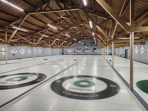
Thistle Curling Club (Winnipeg)
Premier curling rink in Winnipeg, Canada
Distance: Approx. 626 meters
Latitude and longitude: 49.8861,-97.1713
The Thistle Curling Club (also known as The Thistle), located in Winnipeg, Manitoba, is the second oldest curling club in Manitoba.
Weather in this IP's area
broken clouds
20 Celsius
20 Celsius
19 Celsius
21 Celsius
995 hPa
79 %
995 hPa
969 hPa
10000 meters
3.6 m/s
210 degree
80 %
07:11:27
19:33:16