Country:
 Canada
Region:
City:
Latitude and Longitude:
Time Zone:
Postal Code:
IP information under different IP Channel
ip-api
Country
Region
City
ASN
Time Zone
ISP
Blacklist
Proxy
Latitude
Longitude
Postal
Route
IPinfo
Country
Region
City
ASN
Time Zone
ISP
Blacklist
Proxy
Latitude
Longitude
Postal
Route
MaxMind
Country
Region
City
ASN
Time Zone
ISP
Blacklist
Proxy
Latitude
Longitude
Postal
Route
Luminati
Country
CARegion
ab
City
stalbert
ASN
Time Zone
America/Edmonton
ISP
ASN-WIBAND-1
Latitude
Longitude
Postal
db-ip
Country
Region
City
ASN
Time Zone
ISP
Blacklist
Proxy
Latitude
Longitude
Postal
Route
ipdata
Country
Region
City
ASN
Time Zone
ISP
Blacklist
Proxy
Latitude
Longitude
Postal
Route
Popular places and events near this IP address

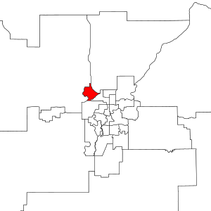
St. Albert, Alberta
City in Alberta, Canada
Distance: Approx. 1192 meters
Latitude and longitude: 53.63694444,-113.62027778
St. Albert is a city in Alberta, Canada, located on the Sturgeon River, northwest of the City of Edmonton, the provincial capital. It was originally settled as a Métis community, and is now the second-largest city in the Edmonton Metropolitan Region.
St. Albert (provincial electoral district)
Provincial electoral district in Alberta, Canada
Distance: Approx. 983 meters
Latitude and longitude: 53.64,-113.63
St. Albert (styled Saint Albert from 1905 to 1909) is a provincial electoral district in Alberta, Canada. The district is one of 87 current districts mandated to return a single member to the Legislative Assembly of Alberta.

Edmonton—St. Albert
Federal electoral district in Alberta, Canada
Distance: Approx. 2061 meters
Latitude and longitude: 53.617,-113.618
Edmonton—St. Albert was a federal electoral district in Alberta, Canada, that was represented in the House of Commons of Canada from 2004 to 2015.
Bellerose Composite High School
Public school in St. Albert, AB, Canada
Distance: Approx. 2201 meters
Latitude and longitude: 53.647262,-113.657507
Bellerose Composite High School is a high school located in northwest St. Albert, Alberta, Canada. It is a member of St.
Sturgeon Community Hospital
Hospital in Alberta, Canada
Distance: Approx. 2677 meters
Latitude and longitude: 53.655278,-113.626111
Located just northwest of Edmonton, the Sturgeon Community Hospital is a 167-bed hospital that provides a wide variety of health services to the community of St. Albert and surrounding area.
Greater St. Albert Catholic Schools
School district in Alberta, Canada
Distance: Approx. 633 meters
Latitude and longitude: 53.63722222,-113.6325
Greater St. Albert Catholic Schools or Greater St. Albert Roman Catholic Separate School District No.

St. Albert Grain Elevator Park
Museum in Alberta, Canada
Distance: Approx. 328 meters
Latitude and longitude: 53.63313,-113.64089
St. Albert Grain Elevator Park is an open-air museum which features two historic grain elevators and a reconstructed railway station. The two elevators are a 1906 Brackman-Ker Milling Company Elevator and a 1929 Alberta Wheat Pool Elevator, both which were designated as Provincial Historic Resources in January 2007.
William D. Cuts Junior High School
School in Canada
Distance: Approx. 1900 meters
Latitude and longitude: 53.64836111,-113.6445
William D. Cuts Junior High School is a public middle school located in St. Albert, Alberta. Constructed in 1977, the single-story brick structure has over 400 students.
Lorne Akins Junior High School
Distance: Approx. 1904 meters
Latitude and longitude: 53.6342,-113.6077
Lorne Akins Junior High is a school in St. Albert, Alberta that teaches students in grades seven through nine. The school is named for the farmer that owned the property on which the school is currently built, first opening in 1963 as Paul Kane High School.
Sir Alexander Mackenzie Elementary School (St. Albert)
Alberta elementary school
Distance: Approx. 2384 meters
Latitude and longitude: 53.62854,-113.600667
Sir Alexander Mackenzie Elementary School (SAM) is a school in St. Albert, Alberta, Canada, and is a part of St. Albert Public Schools.
Joseph M. Demko School
Alberta elementary-junior high school
Distance: Approx. 3280 meters
Latitude and longitude: 53.6609412,-113.6456665
Joseph M. Demko School is a dual-track elementary-junior high school in the new Jensen lakes neighborhood in St. Albert, Alberta, Canada. The school is a member of St.
Leo Nickerson Elementary School
Public school in St. Albert, Alberta, Canada
Distance: Approx. 1936 meters
Latitude and longitude: 53.6294,-113.6073
Leo Nickerson Elementary School is a dual-track school in St. Albert, Alberta, Canada, and is a part of St. Albert Public Schools.
Weather in this IP's area
clear sky
30 Celsius
29 Celsius
29 Celsius
31 Celsius
1008 hPa
32 %
1008 hPa
936 hPa
10000 meters
3.6 m/s
280 degree
06:55:13
20:09:53