64.47.98.31 - IP Lookup: Free IP Address Lookup, Postal Code Lookup, IP Location Lookup, IP ASN, Public IP
Country:
 USA
USARegion:
City:
Location:
Time Zone:
Postal Code:
ISP:
ASN:
language:
User-Agent:
Proxy IP:
Blacklist:
IP information under different IP Channel
ip-api
Country
Region
City
ASN
Time Zone
ISP
Blacklist
Proxy
Latitude
Longitude
Postal
Route
db-ip
Country
Region
City
ASN
Time Zone
ISP
Blacklist
Proxy
Latitude
Longitude
Postal
Route
IPinfo
Country
Region
City
ASN
Time Zone
ISP
Blacklist
Proxy
Latitude
Longitude
Postal
Route
IP2Location
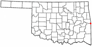
64.47.98.31Country
usRegion
arkansas
City
fort smith
Time Zone
America/Chicago
ISP
Language
User-Agent
Latitude
Longitude
Postal
ipdata
Country
Region
City
ASN
Time Zone
ISP
Blacklist
Proxy
Latitude
Longitude
Postal
Route
Popular places and events near this IP address
Arkoma, Oklahoma
Town in Oklahoma, United States
Distance: Approx. 5459 meters
Latitude and longitude: 35.3375,-94.44388889
Arkoma is a town in LeFlore County, Oklahoma, United States. It is part of the Fort Smith, Arkansas-Oklahoma Metropolitan Statistical Area. The population was 1,989 at the 2010 census, a decline from 2,180 in 2000.

Ozark–St. Francis National Forest
United States National Forest located in the state of Arkansas
Distance: Approx. 6736 meters
Latitude and longitude: 35.275,-94.47555556
The Ozark – St. Francis National Forest is a United States National Forest that is located in the state of Arkansas. It is composed of two separate forests, Ozark National Forest in the Ozark Mountains; and St.

Southside High School (Fort Smith, Arkansas)
Public school in Fort Smith, Arkansas, United States
Distance: Approx. 5820 meters
Latitude and longitude: 35.34861111,-94.38861111
Southside High School is a comprehensive public high school in Fort Smith, Arkansas, United States. Southside provides secondary education for students in grades 9 through 12 and is one of two public high schools in Fort Smith, the other being Northside High School, both of which are administered by the Fort Smith School District. The school is a three-time recipient of the National Blue Ribbon Schools Award of Excellence by the U.S. Department of Education (ED).

Fort Smith Regional Airport
Public airport in Fort Smith, Arkansas, US
Distance: Approx. 5570 meters
Latitude and longitude: 35.33666667,-94.3675
Fort Smith Regional Airport (IATA: FSM, ICAO: KFSM, FAA LID: FSM) is a public use airport located near the Interstate 540 freeway three nautical miles (6 km) southeast of the central business district of Fort Smith, in Sebastian County, Arkansas, United States. FSM is governed by the Fort Smith Airport Commission as established by the City of Fort Smith, Arkansas. It serves the transportation needs of residents and businesses of western Arkansas and eastern Oklahoma.
KFPW-FM
Radio station in Barling, Arkansas
Distance: Approx. 5363 meters
Latitude and longitude: 35.265,-94.365
KFPW-FM (94.5 MHz) is an American commercial radio station located in Barling, Arkansas, broadcasting to the Fort Smith, Arkansas, area. KFPW-FM airs an active rock music format from Citadel Media's The Nerve and is branded as "The Fort 94.5".
KTCS (AM)
Radio station in Fort Smith, Arkansas
Distance: Approx. 3642 meters
Latitude and longitude: 35.27777778,-94.37638889
KTCS (branded as simulcasting KTCS FM on AM 1410) is a radio station serving the Fort Smith metropolitan area with a New Country format. The station broadcasts on AM frequency 1410 kHz and is currently under ownership of Big Chief Broadcasting Co.
Battle of Massard Prairie
1864 battle of the American Civil War
Distance: Approx. 2760 meters
Latitude and longitude: 35.31138889,-94.38127778
The Battle of Massard Prairie was fought on July 27, 1864 in Sebastian County, Arkansas during the American Civil War. Confederate troops led by Brigadier-General Richard M. Gano successfully launched a surprise attack on a Union camp held by four companies of the 6th Kansas Cavalry, capturing prisoners and equipment. The battle exemplified the hit-and-run nature of the Civil War in Arkansas on the western border: this was a war of raids and ambushes involving small forces, not drawn-out, large-scale battles.

Maness Schoolhouse
United States historic place
Distance: Approx. 6596 meters
Latitude and longitude: 35.29722222,-94.33472222
The Maness Schoolhouse is an American historic school building at 8801 Wells Lake Road in Sebastian County, Arkansas, about 2 miles (3.2 km) south of Barling. It is a single-story stone structure, with a side gable roof and a projecting gable portico over its main entrance. It was built in 1937 as a one-room schoolhouse with funding from the Works Progress Administration, and is the only surviving structure of the former community of Massard, which was disincorporated and demolished to make way for Fort Chaffee in 1941.

Oscar Chambers House
Historic house in Arkansas, United States
Distance: Approx. 6107 meters
Latitude and longitude: 35.35305556,-94.39916667
The Oscar Chamber House is a historic house at 3200 South Dallas Street in Fort Smith, Arkansas. Built in 1963–64 to a design by Arkansas architect Ernie Jacks, it is a prominent local example of residential Mid-Century Modern architecture, set in a neighborhood of more conventional ranch and split entry houses. It is a single-story frame structure, with a broad gabled roof, vertical board siding, and a concrete foundation.

Arkoma School
United States historic place
Distance: Approx. 6709 meters
Latitude and longitude: 35.355,-94.43333333
The Arkoma School in Arkoma in Le Flore County, Oklahoma was a Works Progress Administration-funded project completed in 1937. It was listed on the National Register of Historic Places in 1988. It is a four-room 74 by 42 feet (23 m × 13 m) building built of cut and coursed local sandstone, with a hipped roof.

Elmwood Cemetery (Fort Smith, Arkansas)
Historic cemetery in Arkansas, United States
Distance: Approx. 3248 meters
Latitude and longitude: 35.3275,-94.41222222
Elmwood Cemetery, also known historically as the Poor Farm Cemetery, is a historic cemetery at Zero and South 24th Streets in Fort Smith, Arkansas. Established in 1891, it is on the grounds of Sebastian County's first poor farm, purchased by the county in 1890. It remained in use at least into the 1940s, and is the only surviving visible element of the poor farm.
Ebbing Air National Guard Base
Airport
Distance: Approx. 5570 meters
Latitude and longitude: 35.33666667,-94.3675
Ebbing Air National Guard Base is an airfield adjacent to the Fort Smith Regional Airport which it shares runways with. It was established in 1953. Since 1953, the Arkansas Air National Guard's 188th Wing (188 WG) has been based at the airfield.
Weather in this IP's area
overcast clouds
7 Celsius
5 Celsius
7 Celsius
7 Celsius
1027 hPa
58 %
1027 hPa
1007 hPa
10000 meters
2.57 m/s
110 degree
100 %