Country:
 USA
USARegion:
City:
Latitude and Longitude:
Time Zone:
Postal Code:
IP information under different IP Channel
ip-api
Country
Region
City
ASN
Time Zone
ISP
Blacklist
Proxy
Latitude
Longitude
Postal
Route
IPinfo
Country
Region
City
ASN
Time Zone
ISP
Blacklist
Proxy
Latitude
Longitude
Postal
Route
MaxMind
Country
Region
City
ASN
Time Zone
ISP
Blacklist
Proxy
Latitude
Longitude
Postal
Route
Luminati
Country
USRegion
ny
City
thebronx
ASN
Time Zone
America/New_York
ISP
MASERGY
Latitude
Longitude
Postal
db-ip
Country
Region
City
ASN
Time Zone
ISP
Blacklist
Proxy
Latitude
Longitude
Postal
Route
ipdata
Country
Region
City
ASN
Time Zone
ISP
Blacklist
Proxy
Latitude
Longitude
Postal
Route
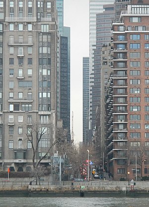
Popular places and events near this IP address

Seventh Avenue station (IND lines)
New York City Subway station in Manhattan
Distance: Approx. 94 meters
Latitude and longitude: 40.762959,-73.981891
The Seventh Avenue station (announced as Seventh Avenue–53rd Street) is an interchange station on the IND Sixth Avenue Line and the IND Queens Boulevard Line of the New York City Subway. Located at the intersection of Seventh Avenue and 53rd Street in Manhattan, it is served by the D and E trains at all times, and the B train on weekdays. The Seventh Avenue station was constructed by the Independent Subway System (IND), and it opened on August 19, 1933.
Adelphi Theatre (New York City)
Former theatre in Manhattan, New York
Distance: Approx. 119 meters
Latitude and longitude: 40.7625,-73.97944444
The Adelphi Theatre (1934–1940 and 1944–1958), originally named the Craig Theatre, opened on December 24, 1928. The Adelphi was located at 152 West 54th Street in Manhattan, with 1,434 seats. The theater was taken over by the Federal Theater Project in 1934 and renamed the Adelphi.

Axa Equitable Center
Office skyscraper in Manhattan, New York
Distance: Approx. 146 meters
Latitude and longitude: 40.761733,-73.981802
Axa Equitable Center (originally the Equitable Tower or Equitable Center West) is an office skyscraper at 787 Seventh Avenue, between 51st and 52nd Streets, in the Midtown Manhattan neighborhood of New York City. Completed in 1986 and designed by Edward Larrabee Barnes, the building measures 752 feet (229 m) tall with 54 stories. Equitable Center West was developed by the Equitable Life Assurance Society (later renamed Equitable Holdings, part of Axa) adjacent to Equitable's existing skyscraper at 1285 Avenue of the Americas.

Lindy's
Restaurant in New York, United States
Distance: Approx. 70 meters
Latitude and longitude: 40.76298,-73.98159
Lindy's was two different deli and restaurant chains in Manhattan, New York City. The first chain, founded by Leo "Lindy" Lindemann, operated from 1921 to 1969. In 1979, the Riese Organization determined that the Lindy's trademark had been abandoned, and opened new restaurants, the last of which closed in February 2018.
53rd Street (Manhattan)
West-east street in Manhattan, New York
Distance: Approx. 73 meters
Latitude and longitude: 40.76277778,-73.98166667
53rd Street is an east–west street in Midtown Manhattan, New York City, which measures 1.83 miles (2.94 km) long. The street runs westbound from Sutton Place across most of the island's width, ending at DeWitt Clinton Park at Eleventh Avenue. The Lexington Avenue – 53rd Street/ 51st Street station complex, one of the busiest in the New York City Subway system, is accessible from this street, and is served by 4, 6, and <6> E and M trains.
A7 (bar)
Distance: Approx. 144 meters
Latitude and longitude: 40.7639,-73.9817
A7 was a club in New York City that between 1981 and 1984, was a main location of the New York hardcore scene. The tiny space was located on the southeast corner of East 7th Street and Avenue A in Manhattan's East Village. The venue hosted fast punk bands such as The Stimulators and The Violators.

Stage Deli
Restaurant in New York, United States
Distance: Approx. 113 meters
Latitude and longitude: 40.76343056,-73.98184444
The Stage Deli, located on Seventh Avenue just two blocks from Carnegie Hall, was a well-known New York City delicatessen, patronized by numerous celebrities. It was first opened in 1937 by Russian-Jewish immigrant Max Asnas. The deli was known for Broadway-themed dishes including the "Mamma Mia!" sandwich.

55th Street (Manhattan)
West-east street in Manhattan, New York
Distance: Approx. 149 meters
Latitude and longitude: 40.7635,-73.9793
55th Street is a two-mile-long, one-way street traveling east to west across Midtown Manhattan.

1301 Avenue of the Americas
Office skyscraper in Manhattan, New York
Distance: Approx. 122 meters
Latitude and longitude: 40.761983,-73.979841
1301 Avenue of the Americas (also known as the Crédit Agricole CIB Building, formerly the Crédit Lyonnais Building and the J.C. Penney Building) is a 609 ft (186m) tall skyscraper in Manhattan, New York City. It is located on the west side of Sixth Avenue (Avenue of the Americas) between 52nd and 53rd Streets.

Sheraton New York Times Square Hotel
Hotel in Manhattan, New York
Distance: Approx. 83 meters
Latitude and longitude: 40.7625,-73.9817
The Sheraton New York Times Square Hotel is a 501 ft (153 m), 51-story hotel located near Times Square in Midtown Manhattan, New York City. It faces 7th Avenue, 52nd Street, and 53rd Street. It is one of the world's 100 tallest hotels, and one of the tallest hotels in New York City.
Jimmy Ryan's
Jazz club in New York City
Distance: Approx. 35 meters
Latitude and longitude: 40.76305556,-73.98055556
Jimmy Ryan's was a jazz club in New York City, USA, located at 53 West 52nd Street from 1934 to 1962 and 154 West 54th Street from 1962–1983. It was a venue for performances of Dixieland jazz.
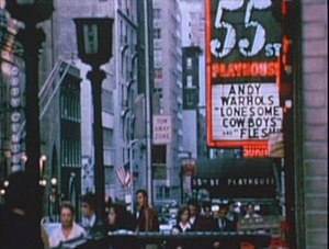
55th Street Playhouse
Former theater in Manhattan, New York
Distance: Approx. 109 meters
Latitude and longitude: 40.763743,-73.9804429
The 55th Street Playhouse—periodically referred to as the 55th Street Cinema and Europa Theatre—was a 253-seat movie house at 154 West 55th Street, Midtown Manhattan, New York City, that opened on May 20, 1927. Many classic art and foreign-language films, including those by Jean Cocteau, Sergei Eisenstein, Federico Fellini, Abel Gance, Fritz Lang, Josef Von Sternberg and Orson Welles, were featured at the theater. Later, Andy Warhol presented many of his notable films (including Flesh (1968) and Lonesome Cowboys (1968) and others) in this building (as well as in other area theaters, including the New Andy Warhol Garrick Theatre) in the late 1960s.
Weather in this IP's area
clear sky
17 Celsius
16 Celsius
16 Celsius
18 Celsius
1031 hPa
35 %
1031 hPa
1028 hPa
10000 meters
5.36 m/s
20 degree
07:10:44
18:10:53