64.47.41.11 - IP Lookup: Free IP Address Lookup, Postal Code Lookup, IP Location Lookup, IP ASN, Public IP
Country:
Region:
City:
Location:
Time Zone:
Postal Code:
IP information under different IP Channel
ip-api
Country
Region
City
ASN
Time Zone
ISP
Blacklist
Proxy
Latitude
Longitude
Postal
Route
Luminati
Country
Region
tx
ASN
Time Zone
America/Chicago
ISP
MASERGY
Latitude
Longitude
Postal
IPinfo
Country
Region
City
ASN
Time Zone
ISP
Blacklist
Proxy
Latitude
Longitude
Postal
Route
IP2Location
64.47.41.11Country
Region
oklahoma
City
norman
Time Zone
America/Chicago
ISP
Language
User-Agent
Latitude
Longitude
Postal
db-ip
Country
Region
City
ASN
Time Zone
ISP
Blacklist
Proxy
Latitude
Longitude
Postal
Route
ipdata
Country
Region
City
ASN
Time Zone
ISP
Blacklist
Proxy
Latitude
Longitude
Postal
Route
Popular places and events near this IP address
Hall Park, Oklahoma
Town in Oklahoma, United States
Distance: Approx. 769 meters
Latitude and longitude: 35.24083333,-97.40694444
Hall Park is a neighborhood in Norman, Oklahoma. It was originally a town in Cleveland County, Oklahoma, United States and part of the Oklahoma City Metropolitan Area. It began in the 1960s and is named after the founder Ike Hall.

Norman, Oklahoma
City in Oklahoma, United States
Distance: Approx. 3710 meters
Latitude and longitude: 35.22083333,-97.44361111
Norman () is the 3rd most populous city in the U.S. state of Oklahoma, with a population of 128,026 as of the 2020 census. It is the most populous city and the county seat of Cleveland County and the second-most populous city in the Oklahoma City metropolitan area after the state capital, Oklahoma City, 20 miles (32 kilometers) north of Norman. The city was settled during the Land Run of 1889, which opened the former Unassigned Lands of Indian Territory to American pioneer settlement.

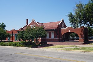
Norman station
Railway station in Norman, Oklahoma
Distance: Approx. 3751 meters
Latitude and longitude: 35.2199,-97.4431
Norman (Amtrak: NOR) is an Amtrak station in Norman, Oklahoma. The station is serviced by the daily Heartland Flyer, which travels from Fort Worth, Texas to Oklahoma City, Oklahoma. The station building was added to the National Register of Historic Places in 1991 as the Santa Fe Depot.
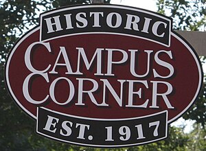
Campus Corner
Commercial district in Norman, Oklahoma
Distance: Approx. 4517 meters
Latitude and longitude: 35.2117,-97.4443
Campus Corner is a college-oriented commercial district in Norman, Oklahoma located directly north of the University of Oklahoma campus. The area is bounded by White Street, University Boulevard, Boyd Street, and Asp Avenue. The district is home to four blocks of unique retail shopping and mixed-use development, including restaurants, bars, clothing stores, OU memorabilia, personal care, and other businesses and professional organizations.
Norman North High School
Co-educational, public, secondary school in Norman, Oklahoma, United States
Distance: Approx. 3089 meters
Latitude and longitude: 35.243975,-97.448373
Norman North High School is a public, co-educational secondary school in Norman, Oklahoma. It was established on August 21, 1997, on the grounds of what had been Longfellow Middle School since 1972. Longfellow has now been relocated to the building that once was Central Mid-High.

Fred Jones Jr. Museum of Art
Museum in Norman, Oklahoma
Distance: Approx. 3552 meters
Latitude and longitude: 35.22,-97.44
The Fred Jones Jr. Museum of Art is an art museum on the University of Oklahoma campus in Norman, Oklahoma.
Moore–Lindsay House
Historic house in Oklahoma, United States
Distance: Approx. 3418 meters
Latitude and longitude: 35.22542883,-97.444246
The Moore–Lindsay House is a Queen Anne style Victorian historic house located in Norman, Oklahoma. It is listed on the National Register of Historic Places, and now houses a museum.
KSSO
Sonlife Radio station in Norman, Oklahoma
Distance: Approx. 3272 meters
Latitude and longitude: 35.22277778,-97.43916667
KSSO (89.3 FM, "Sonlife Radio") is a radio station broadcasting a gospel music format. Licensed to Norman, Oklahoma, United States, the station is currently owned by Family Worship Center Church, Inc.
Naval Air Station Norman
Former United States Navy air station
Distance: Approx. 4246 meters
Latitude and longitude: 35.24,-97.46083333
Naval Air Station Norman is a former United States Navy air station. It was also called a Naval Flight Training Center. The air station opened in 1942 as the navy sought to expand its training capacity during World War II. It was co-located at University of Oklahoma Westheimer Airport.
Norman Music Festival
Distance: Approx. 3652 meters
Latitude and longitude: 35.22111111,-97.44305556
Norman Music Festival (NMF) is an annual three-day American music festival created by Robert Ruiz, Wilmari Ruiz, Marta Burcham, Jim Wilson, Quentin Bomgardner, Kent Johnson, Jonathan Fowler, and Xian Pitt that takes place in downtown Norman, Oklahoma. Each year it highlights performances from many different genres of music. It has indoor and outdoor venues with musicians performing throughout the days and nights.
KOUJ-LP
Radio station in Norman, Oklahoma
Distance: Approx. 3479 meters
Latitude and longitude: 35.22194444,-97.44138889
KOUJ-LP (107.1 FM) is a low-power FM radio station licensed to Norman, Oklahoma, United States. The station is currently licensed to Calvary Chapel Of Norman, Incorporated and carries Christian Rock.
United States Post Office (Norman, Oklahoma)
United States historic place
Distance: Approx. 3469 meters
Latitude and longitude: 35.22277778,-97.44222222
The United States Post Office in Norman, Oklahoma, at 207 E. Gray St., was built in 1933 in Classical Revival style. It was listed on the National Register of Historic Places in 2000 as United States Post Office—Norman. It was deemed "an outstanding example of a federally designed Classical Revival style government building".
Weather in this IP's area
clear sky
4 Celsius
-1 Celsius
3 Celsius
4 Celsius
1024 hPa
61 %
1024 hPa
979 hPa
10000 meters
5.66 m/s
360 degree


