64.47.188.165 - IP Lookup: Free IP Address Lookup, Postal Code Lookup, IP Location Lookup, IP ASN, Public IP
Country:
Region:
City:
Location:
Time Zone:
Postal Code:
ISP:
ASN:
language:
User-Agent:
Proxy IP:
Blacklist:
IP information under different IP Channel
ip-api
Country
Region
City
ASN
Time Zone
ISP
Blacklist
Proxy
Latitude
Longitude
Postal
Route
db-ip
Country
Region
City
ASN
Time Zone
ISP
Blacklist
Proxy
Latitude
Longitude
Postal
Route
IPinfo
Country
Region
City
ASN
Time Zone
ISP
Blacklist
Proxy
Latitude
Longitude
Postal
Route
IP2Location
64.47.188.165Country
Region
alberta
City
calgary
Time Zone
America/Edmonton
ISP
Language
User-Agent
Latitude
Longitude
Postal
ipdata
Country
Region
City
ASN
Time Zone
ISP
Blacklist
Proxy
Latitude
Longitude
Postal
Route
Popular places and events near this IP address
CNOOC Petroleum North America
Chinese oil and gas company, Alberta, Canada-based subsidiary of CNOOC
Distance: Approx. 568 meters
Latitude and longitude: 51.04638889,-114.07972222
CNOOC Petroleum North America ULC, formerly known as Nexen, is a Canadian oil and gas company based in Calgary, Alberta. Originally the Canadian subsidiary of US-based Occidental Petroleum (known as Canadian Occidental Petroleum or CanOxy), it became an independent company, Nexen, in 2000. Nexen was acquired by Hong Kong–based CNOOC Limited in 2013, and was rebranded under the current name at the end of 2018.

Calgary Catholic School District
School district in Alberta, Canada
Distance: Approx. 143 meters
Latitude and longitude: 51.04916667,-114.08388889
Calgary Roman Catholic Separate School District No. 1 or the Calgary Catholic School District (CCSD) is the Roman Catholic separate school board in Calgary, Alberta, Canada. It also serves the neighbouring communities of Airdrie, Chestermere, Cochrane and Rocky View County.

Mewata Armoury
Canadian Forces reserve armoury in Calgary, Canada
Distance: Approx. 505 meters
Latitude and longitude: 51.04638889,-114.08944444
Mewata Armoury is a Canadian Forces reserve armoury in Calgary, Alberta, Canada. Mewata ( mə-WAH-tə is derived from the Cree word ᒥᔭᐋᐧᑕᒼ (miyawâtam), meaning "Oh, be joyful". The building was built between 1915 and 1918 for an original cost of CA$282,051 (equivalent to $4,978,676 in 2023).

Nexen Building, Calgary
Office building
Distance: Approx. 582 meters
Latitude and longitude: 51.04638889,-114.07944444
801 Seventh Avenue S.W., commonly known as the Nexen Building, is a high rise office building in downtown Calgary, Alberta, Canada. It is a 37-storey skyscraper, with a height of 153 m (502 ft). It was designed by CPV Group Architects and Engineers Ltd and built by CANA Construction Company Limited.

Sunnyside, Calgary
Neighbourhood in Calgary, Alberta, Canada
Distance: Approx. 300 meters
Latitude and longitude: 51.05277778,-114.08583333
Sunnyside is an innercity community in Calgary, Alberta located on the north side of the Bow River immediately adjacent to Calgary's downtown. The community partners with the neighbouring community of Hillhurst to form the Hillhurst-Sunnyside Community Association. The combined communities have an area redevelopment plan in place, revised in 2009.

Elveden Centre
Office in Calgary, Canada
Distance: Approx. 540 meters
Latitude and longitude: 51.04694444,-114.07944444
Elveden Centre is a three-tower office building located at 717 7th Avenue Southwest in Calgary, Alberta. Designed by Alberta architectural firm Rule Wynn and Rule and built in three phases between 1959 and 1964, it is one of Calgary's best examples of International-style architecture.

Downtown West End, Calgary
Neighbourhood in Calgary, Alberta, Canada
Distance: Approx. 325 meters
Latitude and longitude: 51.04722222,-114.08611111
The Downtown West End is a neighbourhood within the western portions of downtown Calgary, Alberta, Canada. It is bounded to the north by the Bow River, to the east by 9th Street W, to the south by the CPR Tracks and to the west by 14th Street W. West End is a high density residential community, largely made up of condominiums and apartment buildings, with only 25 single-family detached homes remaining in the neighbourhood. Downtown Calgary was established as a neighbourhood in 1884, after the arrival of the Canadian Pacific Railway in 1883.

Louise Bridge
Bridge in Calgary, Alberta, Canada
Distance: Approx. 121 meters
Latitude and longitude: 51.05116,-114.0849
The Louise Bridge crosses the Bow River in Calgary, Alberta, Canada. The bridge connects Downtown West End with Memorial Drive and Kensington. It is configured with reversible lanes to accommodate higher traffic into Downtown during the early morning hours, and higher outbound traffic during the afternoon commute.

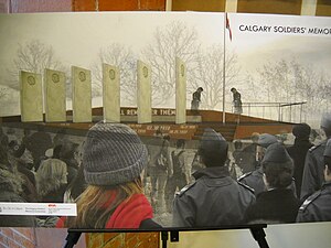
Calgary Soldiers' Memorial
War monument in Calgary, Alberta, Canada
Distance: Approx. 264 meters
Latitude and longitude: 51.05083333,-114.08888889
The Calgary Soldiers' Memorial is a war monument in Calgary, Alberta, that was dedicated on April 9, 2011, the anniversary of the Battle of Vimy Ridge. The monument is dedicated to Calgary area soldiers who have given their lives in war and military service overseas. The monument is located on Memorial Drive and bears the names of 3,000 fallen soldiers from the Calgary area who died in military service.

Downtown West–Kerby station
Light rail station in Calgary, Alberta, Canada
Distance: Approx. 356 meters
Latitude and longitude: 51.04716667,-114.08731667
Downtown West–Kerby station is a Calgary CTrain station in Calgary, Alberta, Canada. It is located in the free-fare zone on the 7 Avenue transit-only corridor. It is the only station in the downtown corridor that is exclusively for the Blue Line.

Southam Building
Distance: Approx. 551 meters
Latitude and longitude: 51.0521,-114.0781
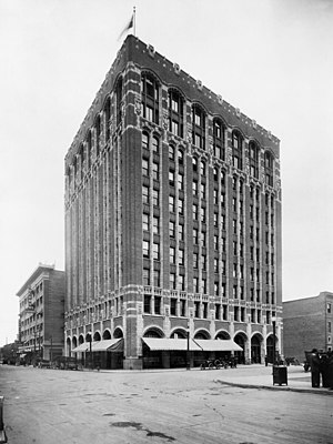
The Southam Building was a ten-storey office tower located at 130 7th Avenue Southwest in Calgary, Alberta, Canada. Designed by Montreal architectural firm Brown and Vallance and built between 1912 and 1913, the Southam Building was one of Calgary's best examples of Gothic Revival architecture. Between 1913 and 1932 the building housed the offices of the Calgary Daily Herald, during which time it was also known as the Herald Building.

Centennial Planetarium
Distance: Approx. 416 meters
Latitude and longitude: 51.04744,-114.08947
The Centennial Planetarium, located at 701 11 Street SW in Calgary, Alberta, was designed by Calgary architectural firm McMillan Long and Associates and opened in 1967 for the Canadian Centennial, it is one of Calgary's best examples of Brutalist architecture, winning several awards open its opening. As of 2019, the building houses Contemporary Calgary, a public art gallery.
Weather in this IP's area
scattered clouds
-8 Celsius
-14 Celsius
-8 Celsius
-8 Celsius
1026 hPa
76 %
1026 hPa
891 hPa
10000 meters
3.58 m/s
6.5 m/s
276 degree
45 %