Country:
 USA
USARegion:
City:
Latitude and Longitude:
Time Zone:
Postal Code:
IP information under different IP Channel
ip-api
Country
Region
City
ASN
Time Zone
ISP
Blacklist
Proxy
Latitude
Longitude
Postal
Route
IPinfo
Country
Region
City
ASN
Time Zone
ISP
Blacklist
Proxy
Latitude
Longitude
Postal
Route
MaxMind
Country
Region
City
ASN
Time Zone
ISP
Blacklist
Proxy
Latitude
Longitude
Postal
Route
Luminati
Country
USRegion
wa
City
seattle
ASN
Time Zone
America/Los_Angeles
ISP
MASERGY
Latitude
Longitude
Postal
db-ip
Country
Region
City
ASN
Time Zone
ISP
Blacklist
Proxy
Latitude
Longitude
Postal
Route
ipdata
Country
Region
City
ASN
Time Zone
ISP
Blacklist
Proxy
Latitude
Longitude
Postal
Route
Popular places and events near this IP address
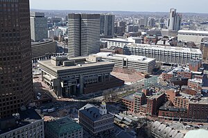
Government Center, Boston
Area in downtown Boston, Massachusetts
Distance: Approx. 72 meters
Latitude and longitude: 42.3607,-71.05922778
Government Center is an area in downtown Boston, centered on City Hall Plaza. Formerly the site of Scollay Square, it is now the location of Boston City Hall, courthouses, state and federal office buildings, and a major MBTA subway station, also called Government Center. Its development was controversial, as the project displaced thousands of residents and razed several hundred homes and businesses.
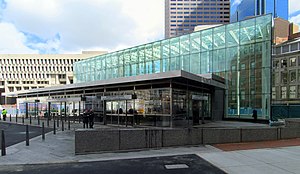
Government Center station (MBTA)
Subway station in Boston, Massachusetts, US
Distance: Approx. 86 meters
Latitude and longitude: 42.35944444,-71.05944444
Government Center station is an MBTA subway station in Boston, Massachusetts. It is located at the intersection of Tremont, Court and Cambridge Streets in the Government Center area. It is a transfer point between the light rail Green Line and the rapid transit Blue Line.

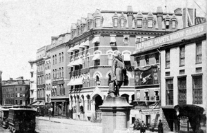
Scollay Square
Former public square in downtown Boston, Massachusetts
Distance: Approx. 86 meters
Latitude and longitude: 42.35944444,-71.05944444
Scollay Square (c. 1838–1962) was a city square in downtown Boston, Massachusetts. It was named for William Scollay, a prominent local developer and militia officer who bought a landmark four-story merchant building at the intersection of the Cambridge and Court Streets in the year 1795.

Boston City Hall
City hall of Boston, Massachusetts since 1969
Distance: Approx. 81 meters
Latitude and longitude: 42.36032222,-71.05796667
Boston City Hall is the seat of city government of Boston, Massachusetts. It includes the offices of the mayor of Boston and the Boston City Council. The current hall was built in 1968 to assume the functions of the Old City Hall.

Boston Planning & Development Agency
Municipal planning and development agency for Boston
Distance: Approx. 81 meters
Latitude and longitude: 42.36032222,-71.05796667
The Boston Planning & Development Agency (BPDA), formerly the Boston Redevelopment Authority (BRA), is a Massachusetts public agency that serves as the municipal planning and development agency for Boston, working on both housing and commercial developments. As an agency concerned with urban planning, the BPDA does not consider requests for zoning variances from individual property owners. These are heard by the city's own Zoning Board of Appeals, a seven-person body appointed by the Mayor of Boston.

Sears' Crescent and Sears' Block
United States historic place
Distance: Approx. 86 meters
Latitude and longitude: 42.35944444,-71.05944444
Sears' Crescent and Sears' Block are a pair of adjacent historic buildings located along Cornhill in Boston, Massachusetts. It is adjacent to City Hall and City Hall Plaza, Government Center, Boston. Sears' Crescent was constructed in 1816 as a series of Federal period commercial rowhouses.
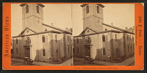
Brattle Street Church
Church building in Massachusetts, United States
Distance: Approx. 85 meters
Latitude and longitude: 42.3603,-71.0579
The Brattle Street Church (1698–1876) was a Congregational (1698 – c. 1805) and Unitarian (c. 1805–1876) church on Brattle Street in Boston, Massachusetts.

Brattle Street (Boston)
Former street in Boston from 1694 to 1962
Distance: Approx. 85 meters
Latitude and longitude: 42.3603,-71.0579
Brattle Street, which existed from 1694 to 1962, was a street in Boston, Massachusetts, located on the current site of City Hall Plaza, at Government Center.
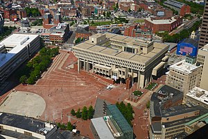
Boston City Hall Plaza
Distance: Approx. 30 meters
Latitude and longitude: 42.36027778,-71.05916667
City Hall Plaza in Boston, Massachusetts, is a large, open, public space in the Government Center area of the city. The architectural firm Kallmann McKinnell & Knowles designed the plaza in 1962 to accompany Boston's new City Hall building. The multi-level, irregularly shaped plaza consists of red brick and concrete.

American House (Boston)
Hotel in Massachusetts, United States
Distance: Approx. 78 meters
Latitude and longitude: 42.3608,-71.0589
The American House (established 1835) was a hotel in Boston, Massachusetts, located on Hanover Street. Abraham W. Brigham, Lewis Rice (1837–1874), Henry B. Rice (1868–1888), and Allen C. Jones (c. 1921) served as proprietors.

Quincy House (Boston)
Hotel in Boston, Massachusetts
Distance: Approx. 20 meters
Latitude and longitude: 42.36,-71.0587
The Quincy House was a hotel in downtown Boston, Massachusetts, United States. Located on the corner of Brattle Street and Brattle Square in the neighborhood of Scollay Square, it was in operation for most of the 19th and early 20th centuries. It was the largest hotel in Boston in the late 19th century, and was a popular destination for prominent guests to the city.
Crawford House (Boston, Massachusetts)
Hotel in Massachusetts, United States
Distance: Approx. 60 meters
Latitude and longitude: 42.3598,-71.0595
The Crawford House was a hotel and restaurant in downtown Boston, Massachusetts. Located on Court and Brattle Streets in Scollay Square, it was in operation during the late nineteenth and early twentieth centuries, and was for a time among the leading hotels in the city. The building was demolished in 1962 as part of the Government Center project.
Weather in this IP's area
clear sky
26 Celsius
26 Celsius
23 Celsius
29 Celsius
1024 hPa
38 %
1024 hPa
1024 hPa
10000 meters
2.68 m/s
5.36 m/s
114 degree
4 %
06:25:45
18:52:17