Country:
 USA
USARegion:
City:
Latitude and Longitude:
Time Zone:
Postal Code:
IP information under different IP Channel
ip-api
Country
Region
City
ASN
Time Zone
ISP
Blacklist
Proxy
Latitude
Longitude
Postal
Route
IPinfo
Country
Region
City
ASN
Time Zone
ISP
Blacklist
Proxy
Latitude
Longitude
Postal
Route
MaxMind
Country
Region
City
ASN
Time Zone
ISP
Blacklist
Proxy
Latitude
Longitude
Postal
Route
Luminati
Country
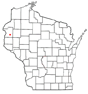
USRegion
wi
City
amery
ASN
Time Zone
America/Chicago
ISP
AIRSTREAMCOMM-NET
Latitude
Longitude
Postal
db-ip
Country
Region
City
ASN
Time Zone
ISP
Blacklist
Proxy
Latitude
Longitude
Postal
Route
ipdata
Country
Region
City
ASN
Time Zone
ISP
Blacklist
Proxy
Latitude
Longitude
Postal
Route
Popular places and events near this IP address

Amery, Wisconsin
City in Wisconsin, United States
Distance: Approx. 5695 meters
Latitude and longitude: 45.30972222,-92.36277778
Amery ( AY-mər-ee) is a city in Polk County, Wisconsin, United States, along the Apple River. It is a part of Wisconsin's 7th congressional district. The population was 2,902 at the 2010 census.
Lincoln, Polk County, Wisconsin
Town in Wisconsin, United States
Distance: Approx. 4500 meters
Latitude and longitude: 45.33277778,-92.3525
Lincoln is a town in Polk County, Wisconsin, United States. The population was 2,304 at the 2000 census. The unincorporated community of Deronda is located in the town.
Amery High School
School in Amery, Polk County, WI, United States
Distance: Approx. 6916 meters
Latitude and longitude: 45.301815,-92.351587
Amery High School is a public school serving grades 9 through 12 in Amery, Polk County, Wisconsin, United States.
Ubet, Wisconsin
Unincorporated community in Wisconsin, United States
Distance: Approx. 9872 meters
Latitude and longitude: 45.35333333,-92.52888889
Ubet is an unincorporated community in the town of Garfield in Polk County, Wisconsin, United States. Ubet has been noted for its unusual place name.
Amery School District
School district in Wisconsin, United States
Distance: Approx. 6927 meters
Latitude and longitude: 45.30222222,-92.35055556
The School District of Amery is school district located in Amery, Wisconsin, United States. It serves students from early childhood through 12th grade. The School District of Amery has four buildings located on a campus within the Amery City limits and the buildings are as follows, Amery High School, Amery Middle School, Amery Intermediate School, Amery Lien Elementary School.

Amery Municipal Airport
Airport
Distance: Approx. 8232 meters
Latitude and longitude: 45.28111111,-92.37527778
Amery Municipal Airport (IATA: AHH, ICAO: KAHH, FAA LID: AHH) is a city owned public use airport located two nautical miles (4 km) south of the central business district of Amery, a city in Polk County, Wisconsin, United States. It is included in the Federal Aviation Administration (FAA) National Plan of Integrated Airport Systems for 2021–2025, in which it is categorized as a local general aviation facility. The airport was damaged by high winds in September 2005.
Deronda, Wisconsin
Unincorporated community in Wisconsin, United States
Distance: Approx. 5800 meters
Latitude and longitude: 45.30361111,-92.42833333
Deronda is an unincorporated community located in the town of Lincoln, Polk County, Wisconsin, United States. Deronda is 3 miles (4.8 km) west of Amery.
Lykens, Wisconsin
Unincorporated community in Wisconsin, United States
Distance: Approx. 9547 meters
Latitude and longitude: 45.42444444,-92.46916667
Lykens is an unincorporated community located in the town of Balsam Lake, Polk County, Wisconsin, United States. Lykens Lake is a 20 acre lake located in Polk County. It has a maximum depth of 10 feet.
Little Falls, Polk County, Wisconsin
Unincorporated community in Wisconsin, United States
Distance: Approx. 8842 meters
Latitude and longitude: 45.27388889,-92.41888889
Little Falls is an unincorporated community located in the town of Alden, Polk County, Wisconsin, United States. Little Falls is located at the junction of County Highways C and PP 3.6 miles (5.8 km) southwest of Amery. The Apple River flows through Little Falls and was once dammed where County Road C now crosses the river.
Balsam Branch Wildlife Area
Protected area in Wisconsin, US
Distance: Approx. 5127 meters
Latitude and longitude: 45.363578,-92.466321
The Balsam Branch Wildlife Area is a 180 acres (73 ha) tract of protected land in central Polk County, Wisconsin, managed by the Wisconsin Department of Natural Resources (WDNR). The wildlife area is characterized by marshland, prairie fields, and a pond set in the center of the property.
Weather in this IP's area
scattered clouds
21 Celsius
20 Celsius
20 Celsius
22 Celsius
1020 hPa
31 %
1020 hPa
983 hPa
10000 meters
6.18 m/s
12.22 m/s
186 degree
36 %
07:30:11
18:18:48