Country:
 USA
USARegion:
City:
Latitude and Longitude:
Time Zone:
Postal Code:
IP information under different IP Channel
ip-api
Country
Region
City
ASN
Time Zone
ISP
Blacklist
Proxy
Latitude
Longitude
Postal
Route
IPinfo
Country
Region
City
ASN
Time Zone
ISP
Blacklist
Proxy
Latitude
Longitude
Postal
Route
MaxMind
Country
Region
City
ASN
Time Zone
ISP
Blacklist
Proxy
Latitude
Longitude
Postal
Route
Luminati
Country
USASN
Time Zone
America/Chicago
ISP
UIA
Latitude
Longitude
Postal
db-ip
Country
Region
City
ASN
Time Zone
ISP
Blacklist
Proxy
Latitude
Longitude
Postal
Route
ipdata
Country
Region
City
ASN
Time Zone
ISP
Blacklist
Proxy
Latitude
Longitude
Postal
Route
Popular places and events near this IP address

Wrightwood, California
Unincorporated community in California, United States
Distance: Approx. 31 meters
Latitude and longitude: 34.36083333,-117.63333333
Wrightwood is a census-designated place in San Bernardino County, California. It sits at an elevation of 6,208 feet (1,892 m). The population was 4,525 at the 2010 census, up from the population of 3,837 at the 2000 census.
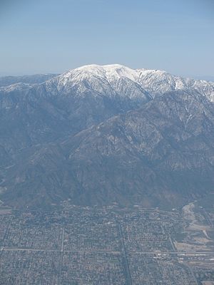
Mount San Antonio
Highest peak of the San Gabriel Mountains in California, United States
Distance: Approx. 8103 meters
Latitude and longitude: 34.2888927,-117.6467218
Mount San Antonio, commonly referred to as Mount Baldy or Old Baldy, is a 10,064 ft (3,068 m) summit in the San Gabriel Mountains on the border of Los Angeles and San Bernardino counties of California. Lying within the San Gabriel Mountains National Monument and Angeles National Forest, it is the highest point within the mountain range, the County of Los Angeles, and the Los Angeles metropolitan area. Mount San Antonio's sometimes snow-capped peaks are visible on clear days and dominate the view of the Los Angeles Basin skyline.

Piñon Hills, California
Census-designated place in California, United States
Distance: Approx. 8212 meters
Latitude and longitude: 34.43305556,-117.615
Piñon Hills (from piñón, Spanish for 'pine nut') is a census-designated place in San Bernardino County, California, near the Los Angeles County line. It is located along Pearblossom Highway, 28 miles east of Palmdale, and 15 miles west of the Cajon Pass where Pearblossom Highway meets Interstate 15. The town lies within 25 miles of Hesperia and Victorville.
Mountain High
Winter resort in California
Distance: Approx. 5747 meters
Latitude and longitude: 34.37472,-117.69323
Mountain High resort is a winter resort in the San Gabriel Mountains in Los Angeles County, California. Mountain High is one of the most-visited resorts in Southern California. The resort is located along State Route 2 west of Wrightwood, California.

Big Pines, California
Unincorporated community in California, United States
Distance: Approx. 5611 meters
Latitude and longitude: 34.37888889,-117.69
Big Pines is an unincorporated community in Los Angeles County, California, United States. It is in the Angeles National Forest, San Gabriel Mountains.
Pine Mountain Ridge (California)
Massif of the Transverse Ranges in California, United States
Distance: Approx. 6838 meters
Latitude and longitude: 34.3271,-117.6952
Pine Mountain Ridge (or simply Pine Mountain) is a massif of the Transverse Ranges located in northern Ventura County, and entirely within the Los Padres National Forest. The ridge is a large block of Matilija Sandstone, and reaches some of the highest elevations in the southern Transverse Ranges. The north slope of the ridge is part of the Sespe Wilderness.
Ford Observatory
Distance: Approx. 5053 meters
Latitude and longitude: 34.38194444,-117.68166667
The Clinton B. Ford Observatory (Wrightwood) (Observatory Code 674) is an astronomical observatory that is associated historically with the American Association of Variable Star Observers (AAVSO). The observatory is located near the border of the Angeles National Forest and the San Bernardino National Forest near Wrightwood, California (United States). It was founded by the late astronomer Clinton B. Ford.

Table Mountain Observatory
Astronomy facility in Big Pines, California
Distance: Approx. 5067 meters
Latitude and longitude: 34.382,-117.6818
Table Mountain Observatory (TMO) is an astronomical observation facility operated by NASA's Jet Propulsion Laboratory (California Institute of Technology). It is located in Big Pines, California, in the Angeles National Forest near Wrightwood, north-northeast of Los Angeles, California. TMO is part of JPL's Table Mountain Facility (TMF).
Serrano High School
Public high school in Phelan, California, United States
Distance: Approx. 8005 meters
Latitude and longitude: 34.41277778,-117.57277778
Serrano High School is a public high school in the California High Desert community of Phelan, California. It serves students from Phelan, Wrightwood and Piñon Hills. It is part of the Snowline Joint Unified School District.
Chaparral High School (Phelan, California)
High school in Phelan, California, United States
Distance: Approx. 8242 meters
Latitude and longitude: 34.41805556,-117.57611111
Chaparral High School is a public high school in the community of Phelan in the Victor Valley of the Mojave Desert, located in San Bernardino County, California. The high school is within the Snowline Joint Unified School District. It is accredited by the Western Association of Schools and Colleges.
Yucca Inn, California
Unincorporated community in California, United States
Distance: Approx. 6758 meters
Latitude and longitude: 34.40972222,-117.58944444
Yucca Inn is an unincorporated community in San Bernardino County, in the U.S. state of California.
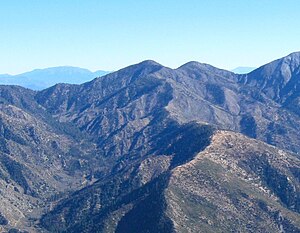
Pine Mountain (San Bernardino County, California)
Mountain in California, United States
Distance: Approx. 5356 meters
Latitude and longitude: 34.3135735,-117.6441656
Pine Mountain is a 9,652-foot-elevation (2,942 meter) summit located in the San Gabriel Mountains, in San Bernardino County, California, United States.
Weather in this IP's area
few clouds
12 Celsius
10 Celsius
10 Celsius
14 Celsius
1009 hPa
50 %
1009 hPa
814 hPa
10000 meters
0.89 m/s
8.94 m/s
192 degree
22 %
06:34:48
18:55:44