64.28.135.88 - IP Lookup: Free IP Address Lookup, Postal Code Lookup, IP Location Lookup, IP ASN, Public IP
Country:
Region:
City:
Location:
Time Zone:
Postal Code:
IP information under different IP Channel
ip-api
Country
Region
City
ASN
Time Zone
ISP
Blacklist
Proxy
Latitude
Longitude
Postal
Route
Luminati
Country
Region
cha
City
chaguanas
ASN
Time Zone
America/Port_of_Spain
ISP
The University of the West IndiesSt Augustine Camp
Latitude
Longitude
Postal
IPinfo
Country
Region
City
ASN
Time Zone
ISP
Blacklist
Proxy
Latitude
Longitude
Postal
Route
IP2Location
64.28.135.88Country
Region
tunapuna-piarco
City
arouca
Time Zone
America/Port_of_Spain
ISP
Language
User-Agent
Latitude
Longitude
Postal
db-ip
Country
Region
City
ASN
Time Zone
ISP
Blacklist
Proxy
Latitude
Longitude
Postal
Route
ipdata
Country
Region
City
ASN
Time Zone
ISP
Blacklist
Proxy
Latitude
Longitude
Postal
Route
Popular places and events near this IP address

China Clipper
Pan American Airways Martin M-130 flying boat
Distance: Approx. 4254 meters
Latitude and longitude: 10.59527778,-61.33722222
China Clipper (NC14716) was the first of three Martin M-130 four-engine flying boats built for Pan American Airways and was used to inaugurate the first commercial transpacific airmail service from San Francisco to Manila on November 22, 1935. Built at a cost of $417,000 by the Glenn L. Martin Company in Baltimore, Maryland, it was delivered to Pan Am on October 9, 1935. It was one of the largest airplanes of its time.

Arima
Borough in The Royal Chartered Borough of Arima, Trinidad and Tobago
Distance: Approx. 5467 meters
Latitude and longitude: 10.63333333,-61.28333333
Arima, officially The Royal Chartered Borough of Arima is the easternmost and second largest in area of the three boroughs of Trinidad and Tobago. It is geographically adjacent to Sangre Grande and Arouca at the south central foothills of the Northern Range. To the south is the Caroni–Arena Dam.

Tunapuna
Town in Tunapuna–Piarco, Trinidad and Tobago
Distance: Approx. 5474 meters
Latitude and longitude: 10.63333333,-61.38333333
Tunapuna is a town in the East–West Corridor of the island of Trinidad, in Trinidad and Tobago.
Piarco
Town in Tunapuna–Piarco, Trinidad and Tobago
Distance: Approx. 5562 meters
Latitude and longitude: 10.58333333,-61.33333333
Piarco is a town in Trinidad and Tobago. It is situated in the north of the island of Trinidad and is the site of the country's main airport, Piarco International Airport.

Arouca, Trinidad and Tobago
Town in Tunapuna–Piarco, Trinidad and Tobago
Distance: Approx. 5 meters
Latitude and longitude: 10.63333333,-61.33333333
Arouca is a town in the East–West Corridor of Trinidad and Tobago located 19 km (12 mi) east of Port of Spain, along the Eastern Main Road. It is located west of Arima, east of Tunapuna and Tacarigua, south of Lopinot, and north of Piarco. It is governed by the Tunapuna–Piarco Regional Corporation.

Piarco International Airport
Airport serving Port of Spain, Trinidad and Tobago
Distance: Approx. 4254 meters
Latitude and longitude: 10.59527778,-61.33722222
Piarco International Airport (IATA: POS, ICAO: TTPP) is an international airport serving the island of Trinidad and is one of two international airports in Trinidad and Tobago. The airport is located 30 km (19 mi) east of Downtown Port of Spain, located in the suburban town of Piarco. The airport is the primary hub and operating base for the country's national airline, as well as the Caribbean's largest airline, Caribbean Airlines.
Tunapuna–Piarco
Region
Distance: Approx. 5470 meters
Latitude and longitude: 10.6333,-61.3833
Tunapuna–Piarco is one of the 9 regions of Trinidad and Tobago. It is the most populous region in the country by total population and the fifth-largest by total land area. Geographically located in Northern Trinidad, Tunapuna–Piarco shares its borders with the regions of San Juan–Laventille to the west, Couva–Tabaquite–Talparo to the south, the Borough of Chaguanas to the south-west, Sangre Grande to the east and the Caribbean Sea to the north.

Tacarigua
Distance: Approx. 3651 meters
Latitude and longitude: 10.63333333,-61.36666667
Tacarigua (originally San Pablo de Tacarigua) is a town in the East–West Corridor of Trinidad and Tobago, located east of Tunapuna, north of Trincity and west of Arouca. It is on the banks of the Tacarigua River. The city is governed by the Tunapuna–Piarco Regional Corporation.
Bon Air High School
Distance: Approx. 799 meters
Latitude and longitude: 10.631489,-61.326232
Bon Air Secondary School is a co-educational secondary school in Arouca, Trinidad and Tobago. It is located at the Corner of Bon Air Gardens Junction and the Priority Bus Route, Arouca. Bon Air Secondary School is a five year secondary school consisting of Forms 1-5.
D'Abadie
Place in Trinidad and Tobago
Distance: Approx. 1820 meters
Latitude and longitude: 10.63333333,-61.31666667
D'Abadie is a community located in the Tunapuna-Piarco regional corporation in Trinidad and Tobago. Its population is 5,827 people. Some schools include Pinehaven S.D.A. Primary School and D'abadie Government Primary School.
Talparo Formation
Distance: Approx. 5198 meters
Latitude and longitude: 10.6,-61.3
The Talparo Formation is a geologic formation in Trinidad and Tobago. It preserves fossils dating back to the Early Pliocene period.

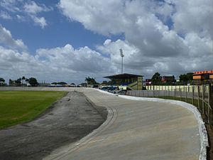
Arima Velodrome
Sporting venue in Trinidad and Tobago
Distance: Approx. 5410 meters
Latitude and longitude: 10.63699694,-61.28399389
The Arima Velodrome is an outdoor velodrome in Arima, Trinidad and Tobago. The velodrome is an open outdoor velodrome serving the Borough of Arima and its suburbs. It hosts grass and concrete surface.
Weather in this IP's area
scattered clouds
30 Celsius
31 Celsius
30 Celsius
30 Celsius
1013 hPa
54 %
1013 hPa
997 hPa
10000 meters
2.57 m/s
130 degree
40 %
