64.255.231.178 - IP Lookup: Free IP Address Lookup, Postal Code Lookup, IP Location Lookup, IP ASN, Public IP
Country:
Region:
City:
Location:
Time Zone:
Postal Code:
IP information under different IP Channel
ip-api
Country
Region
City
ASN
Time Zone
ISP
Blacklist
Proxy
Latitude
Longitude
Postal
Route
Luminati
Country
ASN
Time Zone
America/Toronto
ISP
ITELNETWORKS
Latitude
Longitude
Postal
IPinfo
Country
Region
City
ASN
Time Zone
ISP
Blacklist
Proxy
Latitude
Longitude
Postal
Route
IP2Location
64.255.231.178Country
Region
washington
City
renton
Time Zone
America/Los_Angeles
ISP
Language
User-Agent
Latitude
Longitude
Postal
db-ip
Country
Region
City
ASN
Time Zone
ISP
Blacklist
Proxy
Latitude
Longitude
Postal
Route
ipdata
Country
Region
City
ASN
Time Zone
ISP
Blacklist
Proxy
Latitude
Longitude
Postal
Route
Popular places and events near this IP address

Cedar River (Washington)
River in Washington, United States
Distance: Approx. 2171 meters
Latitude and longitude: 47.50055556,-122.21611111
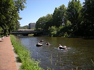
The Cedar River is a river in the U.S. state of Washington. About 45 miles (72 km) long, it originates in the Cascade Range and flows generally west and northwest, emptying into the southern end of Lake Washington. Its upper watershed is a protected area called the Cedar River Watershed, which provides drinking water for the greater Seattle area.

Greenwood Memorial Park (Renton, Washington)
Distance: Approx. 3208 meters
Latitude and longitude: 47.48787,-122.17151
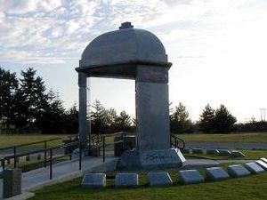
Greenwood Memorial Park is a cemetery in the northwest United States, located in Renton, Washington, a suburb southeast of Seattle. It is notable as the resting place of rock guitarist Jimi Hendrix (1942–1970), a Seattle native; over 14,000 fans visit his memorial annually. Also interred at Greenwood are professional football players Clancy Williams (1942–1986) and Nesby Glasgow (1957–2020).

Will Rogers–Wiley Post Memorial Seaplane Base
Seaplane base in King County, Washington, U.S.
Distance: Approx. 2268 meters
Latitude and longitude: 47.500508,-122.21768083
The Will Rogers–Wiley Post Memorial Seaplane Base (FAA LID: W36) is a seaplane base in Washington state. It is owned and operated by the city of Renton and located on Lake Washington at the northwest corner of Renton Municipal Airport, inside the latter's perimeter fence. The base was named after actor Will Rogers and aviator Wiley Post who took off from the water landing at the beginning of a trip to Alaska, during which they were ultimately killed in an air crash.
Kennydale, Renton, Washington
Distance: Approx. 1294 meters
Latitude and longitude: 47.52083333,-122.20555556
Kennydale is a neighborhood in Renton, Washington, in the United States. As of 2008, it had an estimated population of 4,840. It lies along the southeastern shore of Lake Washington and straddles Interstate 405 which runs north-south between Renton and Bellevue, and borders the Newport Shores neighborhood of Bellevue.

Cedar River Trail
Hiking trail
Distance: Approx. 3626 meters
Latitude and longitude: 47.480257,-122.19908
The Cedar River Regional Trail is a partially paved 17.3-mile (27.8 km) rail trail in Washington. The Cedar River Trail was the former mainline of the Milwaukee Road. It is open for non-motorized use and parallels State Route 169 for much of its length.

Boeing Renton Factory
Airplane assembly facility in Renton, Washington
Distance: Approx. 1881 meters
Latitude and longitude: 47.49934,-122.2089
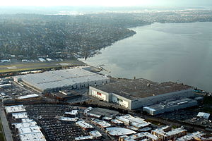
The Boeing Renton Factory is the Boeing Company's manufacturing facility for narrow-body commercial airliners, and their military derivatives. Production includes the Boeing 737 MAX passenger airliner and the Boeing P-8 Poseidon military patrol aircraft. The factory covers 1,100,000 square feet (100,000 m2) of floor space.
Renton High School
Free public school in Renton, Washington, United States
Distance: Approx. 3593 meters
Latitude and longitude: 47.48277778,-122.21166667
Renton High School is a public secondary school (grades 9–12) in downtown Renton, Washington, U.S., about 10 miles southeast of downtown Seattle. Founded in 1911, it is the oldest high school in the Renton School District.

Virginia Mason Athletic Center
Distance: Approx. 2517 meters
Latitude and longitude: 47.535,-122.198
The Virginia Mason Athletic Center (VMAC) is the headquarters and practice facility of the NFL's Seattle Seahawks, in Renton, Washington, a suburb southeast of Seattle. A privately funded facility, it is situated on 19 acres (0.077 km2) of industrial property on the southeastern shore of Lake Washington. The team holds mini-camps and training camp here.
Renton Technical College
Distance: Approx. 2668 meters
Latitude and longitude: 47.49166667,-122.17611111
Renton Technical College (Renton Tech or RTC) is a public community college in Renton, Washington. The college offers bachelor's degrees, associate degrees and certificates of completion in professional-technical fields.

Renton Public Library
Public library in Washington state, United States
Distance: Approx. 3467 meters
Latitude and longitude: 47.482,-122.202
The Renton Public Library is the King County Library System (KCLS) branch library in Renton, Washington, in the United States. It was a city library between its construction in 1966 and 2010, when it was one of the last three non-KCLS members in the county outside of Seattle and it was incorporated into KCLS after what may have been "the most contentious annexation fight in the system's 71 years".
Southport (Renton, Washington)
Mixed-use development in Renton, Washington, United States
Distance: Approx. 1336 meters
Latitude and longitude: 47.50277778,-122.20361111
Southport is a mixed-use development in Renton, Washington, United States. It is located on the southern shore of Lake Washington adjacent to the Renton Landing lifestyle center and the Boeing Renton Factory.

Lake Boren
Lake in Newcastle, Washington
Distance: Approx. 3080 meters
Latitude and longitude: 47.532707,-122.165249
Lake Boren is located just south of downtown Newcastle, Washington. Lake Boren Park is located on its southwestern shore.
Weather in this IP's area
light rain
4 Celsius
2 Celsius
3 Celsius
6 Celsius
1012 hPa
94 %
1012 hPa
1001 hPa
8047 meters
2.57 m/s
140 degree
100 %