Country:
 USA
USARegion:
City:
Latitude and Longitude:
Time Zone:
Postal Code:
IP information under different IP Channel
ip-api
Country
Region
City
ASN
Time Zone
ISP
Blacklist
Proxy
Latitude
Longitude
Postal
Route
IPinfo
Country
Region
City
ASN
Time Zone
ISP
Blacklist
Proxy
Latitude
Longitude
Postal
Route
MaxMind
Country
Region
City
ASN
Time Zone
ISP
Blacklist
Proxy
Latitude
Longitude
Postal
Route
Luminati
Country
USRegion
ne
City
omaha
ASN
Time Zone
America/Chicago
ISP
GALLUP1
Latitude
Longitude
Postal
db-ip
Country
Region
City
ASN
Time Zone
ISP
Blacklist
Proxy
Latitude
Longitude
Postal
Route
ipdata
Country
Region
City
ASN
Time Zone
ISP
Blacklist
Proxy
Latitude
Longitude
Postal
Route
Popular places and events near this IP address

Westside High School (Omaha)
Public school
Distance: Approx. 1757 meters
Latitude and longitude: 41.24722222,-96.05
Westside High School is the only high school of the Westside Community Schools district (also known as District 66 to local residents) of Omaha, Nebraska, United States.
Anime NebrasKon
Anime convention held in Omaha, Nebraska
Distance: Approx. 2591 meters
Latitude and longitude: 41.22786111,-96.02133333
Anime NebrasKon is an annual three-day anime convention held during October at the Mid-America Center in Council Bluffs, Iowa. It is organized by the Nebraska Japanese Animation Society.

College of Saint Mary
Catholic women's college in Omaha, Nebraska, US
Distance: Approx. 2746 meters
Latitude and longitude: 41.24055556,-96.02138889
The College of Saint Mary is a private Catholic women's university in Omaha, Nebraska. Enrollment totaled 1,018 students in fall of 2014: 735 undergraduates, 243 graduate, and 40 non-degree seeking students. It offers more than 30 undergraduate and seven graduate degree programs.

Creighton University Medical Center - Bergan Mercy
Hospital in Nebraska, United States
Distance: Approx. 1975 meters
Latitude and longitude: 41.23945,-96.030811
Creighton University Medical Center - Bergan Mercy (formerly known as Creighton University Medical Center-Saint Joseph Hospital) is a hospital located in Central Omaha, Nebraska in the United States. On April 24, 2012, CUMC signed an agreement to be part of the Alegent Health System (now CHI Health) during the summer of 2012. The CUMC-Saint Joseph Hospital closed June 9, 2017, while simultaneously, the academic medical center and trauma services opened at CHI Health Creighton University Medical Center–Bergan Mercy.

Pipal Park
Distance: Approx. 1637 meters
Latitude and longitude: 41.23333333,-96.0325
Pipal Park is located at 7770 Hascall Street in southwest Omaha, Nebraska.
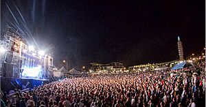
Maha Music Festival
Distance: Approx. 3197 meters
Latitude and longitude: 41.23805556,-96.01472222
The Maha Festival (known until 2021 as Maha Music Festival) is an independent music festival held in Omaha, Nebraska, United States. The festival is owned and operated by YFC, Inc., a non-profit organization.
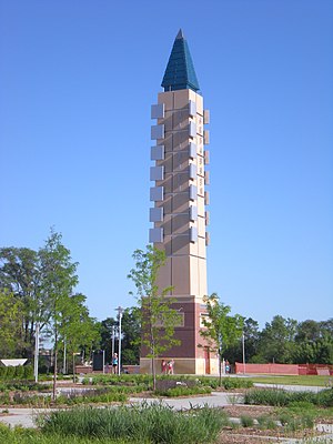
Aksarben Village
Building in Nebraska, U.S.
Distance: Approx. 3173 meters
Latitude and longitude: 41.238,-96.015
Aksarben Village is a mixed-use development in the central United States, located in Omaha, Nebraska. Measuring over one million square feet (93,000 m2), it is on the land of the former Ak-Sar-Ben coliseum and horse track. There is over 750,000 sq ft (70,000 m2) of space for research and business office and 250,000 sq ft (23,000 m2) of retail and entertainment space.
Beth El Cemetery
Jewish cemetery in Douglas County, Nebraska, USA
Distance: Approx. 2348 meters
Latitude and longitude: 41.2112469,-96.0440593
The Beth El Cemetery is a Jewish cemetery located at 4700 South 84th Street (84th and "L" Streets) in Ralston, a city that is south of Omaha, Nebraska.

Platte Institute
American free market advocacy group
Distance: Approx. 2865 meters
Latitude and longitude: 41.25,-96.0281
The Platte Institute for Economic Research is a free market advocacy group and think tank headquartered in Omaha, Nebraska. The group is conservative.

Baxter Arena
Sports arena in Omaha, Nebraska
Distance: Approx. 3295 meters
Latitude and longitude: 41.236,-96.013
Baxter Arena (original working name UNO Community Arena) is a sports arena in the central United States in Omaha, Nebraska. Owned and operated by the University of Nebraska Omaha, it serves as the home of several of the university's intercollegiate athletic teams, known as the Omaha Mavericks. The arena opened to the public on October 23, 2015, when the hockey team defeated Air Force 4–2.
Methodist Hospital (Omaha, Nebraska)
Hospital in Omaha, NE
Distance: Approx. 3123 meters
Latitude and longitude: 41.25858635,-96.04216316
Methodist Hospital is one of three major facilities comprising the Nebraska Methodist Health System. The hospital is located at 8303 Dodge St. in Omaha, Nebraska.
Tal Anderson Field
Baseball park in Nebraska
Distance: Approx. 2852 meters
Latitude and longitude: 41.234,-96.018
Tal Anderson Field is a college baseball park in the central United States, located in Omaha, Nebraska. It is the home field of the University of Nebraska Omaha Mavericks of the Summit League in NCAA Division I. Opened three years ago in 2021 in the Midtown neighborhood, it has a seating capacity of 1,500 for baseball. The artificial turf playing field is aligned northeast by north, at an approximate elevation of 1,030 feet (315 m) above sea level.
Weather in this IP's area
clear sky
32 Celsius
34 Celsius
30 Celsius
34 Celsius
1003 hPa
50 %
1003 hPa
969 hPa
10000 meters
4.63 m/s
310 degree
07:09:11
19:26:31