Country:
 USA
USARegion:
City:
Latitude and Longitude:
Time Zone:
Postal Code:
IP information under different IP Channel
ip-api
Country
Region
City
ASN
Time Zone
ISP
Blacklist
Proxy
Latitude
Longitude
Postal
Route
IPinfo
Country
Region
City
ASN
Time Zone
ISP
Blacklist
Proxy
Latitude
Longitude
Postal
Route
MaxMind
Country
Region
City
ASN
Time Zone
ISP
Blacklist
Proxy
Latitude
Longitude
Postal
Route
Luminati
Country
USRegion
ky
City
burkesville
ASN
Time Zone
America/Chicago
ISP
BLUENET
Latitude
Longitude
Postal
db-ip
Country
Region
City
ASN
Time Zone
ISP
Blacklist
Proxy
Latitude
Longitude
Postal
Route
ipdata
Country
Region
City
ASN
Time Zone
ISP
Blacklist
Proxy
Latitude
Longitude
Postal
Route
Popular places and events near this IP address

Cumberland County, Kentucky
County in Kentucky, United States
Distance: Approx. 3032 meters
Latitude and longitude: 36.78,-85.39
Cumberland County is a county located in the Pennyroyal Plateau region of the U.S. state of Kentucky. As of the 2020 census, the population was 5,888. Its county seat is Burkesville.
Burkesville, Kentucky
City in Kentucky, United States
Distance: Approx. 2832 meters
Latitude and longitude: 36.79027778,-85.37055556
Burkesville is a home rule-class city in Cumberland County, Kentucky, in the United States. Nestled among the rolling foothills of Appalachia and bordered by the Cumberland River to the south and east, it is the seat of its county. The population was 3,713 at the 2020 census.
Waterview, Kentucky
Unincorporated community in Kentucky, United States
Distance: Approx. 5796 meters
Latitude and longitude: 36.81694444,-85.45833333
Waterview is an unincorporated community in Cumberland County, Kentucky, United States. It lies along Route 90 west of the city of Burkesville, the county seat of Cumberland County. Its elevation is 571 feet (174 m).

Grider, Kentucky
Unincorporated community in Kentucky, United States
Distance: Approx. 2786 meters
Latitude and longitude: 36.80416667,-85.42555556
Grider is an unincorporated community in Cumberland County, Kentucky, United States. It lies along Kentucky Route 90, west of the city of Burkesville, the county seat of Cumberland County. Its elevation is 617 feet (188 m).

Bow, Kentucky
Unincorporated community in Kentucky, United States
Distance: Approx. 6634 meters
Latitude and longitude: 36.7625,-85.345
Bow is an unincorporated community in Cumberland County, Kentucky, United States. It lies along Route 90 southeast of the city of Burkesville, the county seat of Cumberland County. Its elevation is 607 feet (185 m).
Bakerton, Kentucky
Unincorporated community in Kentucky, United States
Distance: Approx. 7114 meters
Latitude and longitude: 36.84833333,-85.33361111
Bakerton is an unincorporated community in Cumberland County, Kentucky, United States. It lies near Route 704 northeast of the city of Burkesville, the county seat of Cumberland County. Its elevation is 600 feet (183 m).
WKYR-FM
Radio station in Burkesville, Kentucky
Distance: Approx. 2255 meters
Latitude and longitude: 36.79055556,-85.37972222
WKYR-FM (107.9 FM) is a radio station broadcasting a country music format. Licensed to Burkesville, Kentucky, United States, it is owned by Connie Crabtree through licensee River Country Communications, LLC, and features programming from ABC Radio and Jones Radio Network.

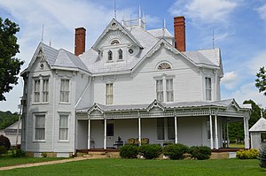
Coe House (Burkesville, Kentucky)
Historic house in Kentucky, United States
Distance: Approx. 2757 meters
Latitude and longitude: 36.79666667,-85.36638889
The Coe House in Burkesville, Kentucky, located at 433 N. Main St., was built in 1908. It was listed on the National Register of Historic Places in 2009. In 2018 the house is on offer for sale, listed at $129,000.

Marrowbone Historic District
Historic district in Kentucky, United States
Distance: Approx. 9961 meters
Latitude and longitude: 36.82833333,-85.50305556
The Marrowbone Historic District is a 1.7-acre (0.69 ha) historic district in Marrowbone, Cumberland County, Kentucky which was listed on the National Register of Historic Places in 1983. It included three contributing buildings. It includes the Marrowbone Presbyterian Church, the Modern Woodmen of America Hall, and the William Barton House (with a small smokehouse behind).

James Baker House (Burkesville, Kentucky)
Historic house in Kentucky, United States
Distance: Approx. 6021 meters
Latitude and longitude: 36.85916667,-85.37666667
The James Baker House near Burkesville, Kentucky is a Federal-style building built in 1820. It was listed on the National Register of Historic Places in 2006. It is located on Kentucky Route 61.
Weather in this IP's area
few clouds
30 Celsius
29 Celsius
30 Celsius
31 Celsius
1015 hPa
32 %
1015 hPa
990 hPa
10000 meters
3.84 m/s
4.2 m/s
63 degree
22 %
06:25:03
18:47:39