64.250.53.214 - IP Lookup: Free IP Address Lookup, Postal Code Lookup, IP Location Lookup, IP ASN, Public IP
Country:
 USA
USARegion:
City:
Location:
Time Zone:
Postal Code:
ISP:
ASN:
language:
User-Agent:
Proxy IP:
Blacklist:
IP information under different IP Channel
ip-api
Country
Region
City
ASN
Time Zone
ISP
Blacklist
Proxy
Latitude
Longitude
Postal
Route
db-ip
Country
Region
City
ASN
Time Zone
ISP
Blacklist
Proxy
Latitude
Longitude
Postal
Route
IPinfo
Country
Region
City
ASN
Time Zone
ISP
Blacklist
Proxy
Latitude
Longitude
Postal
Route
IP2Location
64.250.53.214Country
usRegion
kansas
City
atwood
Time Zone
America/Chicago
ISP
Language
User-Agent
Latitude
Longitude
Postal
ipdata
Country
Region
City
ASN
Time Zone
ISP
Blacklist
Proxy
Latitude
Longitude
Postal
Route
Popular places and events near this IP address
Rawlins County, Kansas
County in Kansas, United States
Distance: Approx. 5008 meters
Latitude and longitude: 39.8,-101.1
Rawlins County is a county located in the U.S. state of Kansas. Its county seat and largest city is Atwood. As of the 2020 census, the county population was 2,561.
Atwood, Kansas
City in Rawlins County, Kansas
Distance: Approx. 368 meters
Latitude and longitude: 39.81,-101.04194444
Atwood is a city in and the county seat of Rawlins County, Kansas, United States. As of the 2020 census, the population of the city was 1,290.

Ludell, Kansas
Unincorporated community in Rawlins County, Kansas
Distance: Approx. 8879 meters
Latitude and longitude: 39.85555556,-100.96
Ludell is a census-designated place (CDP) in Rawlins County, Kansas, United States. As of the 2020 census, the population was 41. It is 5.5 miles (8.9 km) northeast of Atwood.

Shirley Opera House
United States historic place
Distance: Approx. 179 meters
Latitude and longitude: 39.807819,-101.040599
The Shirley Opera House, located at 503 Main St. in Atwood, Kansas, was built in 1907. It is an Early Commercial style building that has served as a theater and as a department store.

Blakeman, Kansas
Unincorporated community in Rawlins County, Kansas
Distance: Approx. 6652 meters
Latitude and longitude: 39.82222222,-101.11722222
Blakeman is an unincorporated community in Rawlins County, Kansas, United States. It is located west of Atwood.
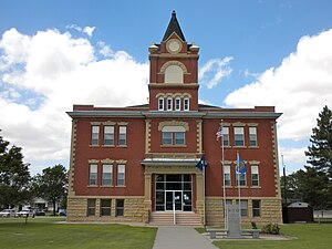
Rawlins County Courthouse
Distance: Approx. 262 meters
Latitude and longitude: 39.80812,-101.03966
The Rawlins County Courthouse is a courthouse in Atwood, Kansas, serving Rawlins County, which is in the 15th judicial district of Kansas. It was designed by the Eisentraut-Colby-Pottenger Company, architects from Sioux City, Iowa.
Rawlins County USD 105
Public school district in Atwood, Kansas
Distance: Approx. 246 meters
Latitude and longitude: 39.80888889,-101.0425
Rawlins County USD 105 is a public unified school district headquartered in Atwood, Kansas, United States. The district includes the communities of Atwood, Herndon, Blakeman, Ludell, and nearby rural areas.
Weather in this IP's area
light snow
-17 Celsius
-24 Celsius
-17 Celsius
-17 Celsius
1025 hPa
79 %
1025 hPa
907 hPa
770 meters
4.01 m/s
7.32 m/s
356 degree
100 %