Country:
 USA
USARegion:
City:
Latitude and Longitude:
Time Zone:
Postal Code:
IP information under different IP Channel
ip-api
Country
Region
City
ASN
Time Zone
ISP
Blacklist
Proxy
Latitude
Longitude
Postal
Route
IPinfo
Country
Region
City
ASN
Time Zone
ISP
Blacklist
Proxy
Latitude
Longitude
Postal
Route
MaxMind
Country
Region
City
ASN
Time Zone
ISP
Blacklist
Proxy
Latitude
Longitude
Postal
Route
Luminati
Country
USRegion
id
City
islandpark
ASN
Time Zone
America/Boise
ISP
BCI
Latitude
Longitude
Postal
db-ip
Country
Region
City
ASN
Time Zone
ISP
Blacklist
Proxy
Latitude
Longitude
Postal
Route
ipdata
Country
Region
City
ASN
Time Zone
ISP
Blacklist
Proxy
Latitude
Longitude
Postal
Route
Popular places and events near this IP address
Ogren Park at Allegiance Field
Baseball stadium in Missoula, Montana
Distance: Approx. 1514 meters
Latitude and longitude: 46.873,-114.007
Ogren Park at Allegiance Field is a stadium in the Western United States, located in Missoula, Montana. Primarily used for minor league baseball, it is the home field of the Missoula PaddleHeads of the Pioneer League. Built in 2004, the ballpark seats 3,500 and replaced Lindbord-Cregg Field.

Mrs. Lydia McCaffery's Furnished Rooms
United States historic place
Distance: Approx. 1896 meters
Latitude and longitude: 46.87638889,-113.99722222
Mrs. Lydia McCaffery's Furnished Rooms, also known as the McCauley Lodging House and now known as the St. Patrick's House, is a former rooming house in Missoula, Montana.

Gleim Building
United States historic place
Distance: Approx. 2127 meters
Latitude and longitude: 46.87222222,-113.99722222
The Gleim Building, 265 W. Front St., Missoula, Montana, was a brothel constructed in 1893 for Mary Gleim, a notorious madam who owned at least eight "female boarding houses". This building serves as an example of a vernacular adaptation of Romanesque architecture. It was listed on the National Register of Historic Places in 1990.
St. Patrick Hospital and Health Sciences Center
Hospital in Montana, United States
Distance: Approx. 1752 meters
Latitude and longitude: 46.8755,-114
Providence St. Patrick Hospital, is a health care facility in Missoula, Montana.

Missoula County Courthouse
United States historic place
Distance: Approx. 2202 meters
Latitude and longitude: 46.87333333,-113.995
The Missoula County Courthouse is located in Missoula, Montana, in the center of Downtown Missoula. It is located at 200 West Broadway, Missoula Montana. It was added to the National Register of Historic Places listings on September 1, 1976.
Garlington Building (Missoula, Montana)
Corporate offices in Missoula, Montana
Distance: Approx. 2220 meters
Latitude and longitude: 46.87333333,-113.99472222
The Garlington Building is a building in Downtown Missoula, Montana. It is located at the 350 Ryman St. The building is a postmodern design.
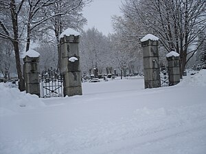
Missoula Cemetery
Cemetery in Missoula, Montana, United States
Distance: Approx. 1088 meters
Latitude and longitude: 46.89305556,-114.02083333
Missoula Cemetery is the second oldest cemetery located in Missoula, Montana, with Fort Missoula Cemetery being the oldest. The Missoula Cemetery was first established in 1884 by the Missoula Valley Improvement Company, a corporation owned by prominent citizens Isadore Cohn, Frank Woody, William H.H. Dickinson and Thomas C Marshall. The land where the cemetery would be built was purchased from the Northern Pacific Railroad for $168.

Atlantic Hotel (Missoula, Montana)
Retail, Hotel in Missoula, Montana
Distance: Approx. 2281 meters
Latitude and longitude: 46.87472222,-113.99277778
The Atlantic Hotel in Downtown Missoula, was listed on the National Register of Historic Places in 1990. The building has also been known as the Circle Square Second Hand Store, the business which it housed in 1990. It is a three-story brick building built in 1902.

St. Francis Xavier Church (Missoula, Montana)
Historic church in Montana, United States
Distance: Approx. 1938 meters
Latitude and longitude: 46.874504,-113.998022
The St. Francis Xavier Church in the Downtown district of Missoula, Montana, is the tallest church in Missoula, and one of the tallest in the state (by height to roof). It is also the tallest church in Missoula County, Montana.
Palace Hotel (Missoula, Montana)
Residential in Missoula, Montana
Distance: Approx. 2232 meters
Latitude and longitude: 46.87222222,-113.99555556
The Palace Hotel is a building located in Downtown Missoula, Montana. Built in 1909, it became one of Missoula's first multi-story hotels. Today, the building houses apartments.

Zip Auto
United States historic place
Distance: Approx. 2197 meters
Latitude and longitude: 46.87194444,-113.99638889
Zip Auto, at 251 W. Main St. in Missoula, Montana, was built in 1937 and was listed on the National Register of Historic Places in 1990. It was designed by Missoula architect H. E. Kirkemo.

Apartment Building at 116 Spruce Street
United States historic place
Distance: Approx. 2332 meters
Latitude and longitude: 46.87444444,-113.99222222
The apartment building at 116 Spruce Street in Missoula, Montana was built between 1902 and 1911. It was listed on the National Register of Historic Places in 1990.
Weather in this IP's area
scattered clouds
5 Celsius
5 Celsius
5 Celsius
7 Celsius
1020 hPa
87 %
1020 hPa
908 hPa
10000 meters
40 %
07:40:49
19:07:33