Country:
 Japan
JapanRegion:
City:
Latitude and Longitude:
Time Zone:
Postal Code:
IP information under different IP Channel
ip-api
Country
Region
City
ASN
Time Zone
ISP
Blacklist
Proxy
Latitude
Longitude
Postal
Route
IPinfo
Country
Region
City
ASN
Time Zone
ISP
Blacklist
Proxy
Latitude
Longitude
Postal
Route
MaxMind
Country
Region
City
ASN
Time Zone
ISP
Blacklist
Proxy
Latitude
Longitude
Postal
Route
Luminati
Country
JPRegion
33
City
mitsukanagawa
ASN
Time Zone
Asia/Tokyo
ISP
GTT Communications Netherlands B.V.
Latitude
Longitude
Postal
db-ip
Country
Region
City
ASN
Time Zone
ISP
Blacklist
Proxy
Latitude
Longitude
Postal
Route
ipdata
Country
Region
City
ASN
Time Zone
ISP
Blacklist
Proxy
Latitude
Longitude
Postal
Route
Popular places and events near this IP address
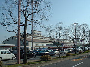
Okayama Airport
Airport in Okayama, Japan
Distance: Approx. 8853 meters
Latitude and longitude: 34.75416667,133.85305556
Okayama Airport (岡山空港, Okayama Kūkō) (IATA: OKJ, ICAO: RJOB) is an airport in Okayama Prefecture, Japan. It is also known as Okayama Momotaro Airport. It is located 18 km (11 mi) northwest of central Okayama City and 11.5 km (7.1 mi) northwest or 30 minutes by bus from Okayama Station.

Akaiwa
City in Chūgoku, Japan
Distance: Approx. 8531 meters
Latitude and longitude: 34.75527778,134.01888889
Akaiwa (赤磐市, Akaiwa-shi) is a city located in Okayama Prefecture, Japan. As of 1 March 2023, the city had an estimated population of 43,359 in 18809 households and a population density of 210 persons per km2. The total area of the city is 209.36 square kilometres (80.83 sq mi).
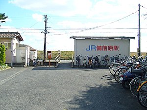
Bizen-Hara Station
Railway station in Okayama, Japan
Distance: Approx. 9810 meters
Latitude and longitude: 34.70497778,133.94489444
Bizen-Hara Station (備前原駅, Bizen-Hara-eki) is a passenger railway station located in the Takebe-chō neighborhood of Kita-ku of the city of Okayama, Okayama Prefecture, Japan. It is operated by West Japan Railway Company (JR West).

Tamagashi Station
Railway station in Okayama, Japan
Distance: Approx. 8816 meters
Latitude and longitude: 34.71686944,133.96459722
Tamagashi Station (玉柏駅, Tamagashi-eki) is a passenger railway station located in Kita-ku of the city of Okayama, Okayama Prefecture, Japan. It is operated by West Japan Railway Company (JR West).

Makiyama Station
Railway station in Okayama, Japan
Distance: Approx. 6159 meters
Latitude and longitude: 34.74093889,133.96075
Makiyama Station (牧山駅, Makiyama-eki) is a passenger railway station located in the Takebe-chō neighborhood of Kita-ku of the city of Okayama, Okayama Prefecture, Japan. It is operated by West Japan Railway Company (JR West).

Nonokuchi Station
Railway station in Okayama, Japan
Distance: Approx. 2454 meters
Latitude and longitude: 34.77126944,133.93241667
Nonokuchi Station (野々口駅, Nonokuchi-eki) is a passenger railway station located in the Takebe-chō neighborhood of Kita-ku of the city of Okayama, Okayama Prefecture, Japan. It is operated by West Japan Railway Company (JR West).
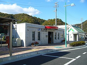
Kanagawa Station (Okayama)
Railway station in Okayama, Japan
Distance: Approx. 351 meters
Latitude and longitude: 34.79211111,133.93388889
Kanagawa Station (金川駅, Kanagawa-eki) is a passenger railway station located in the Takebe-chō neighborhood of Kita-ku of the city of Okayama, Okayama Prefecture, Japan. It is operated by West Japan Railway Company (JR West).

Takebe Station
Railway station in Okayama, Japan
Distance: Approx. 6519 meters
Latitude and longitude: 34.84226389,133.89922778
Takebe Station (建部駅, Takebe-eki) is a passenger railway station located in the Takebe-chō neighborhood of Kita-ku of the city of Okayama, Okayama Prefecture, Japan. It is operated by West Japan Railway Company (JR West).

Fukuwatari Station
Railway station in Okayama, Japan
Distance: Approx. 9176 meters
Latitude and longitude: 34.87052222,133.90380833
Fukuwatari Station (福渡駅, Fukuwatari-eki) is a passenger railway station located in the Takebe-chō neighborhood of Kita-ku of the city of Okayama, Okayama Prefecture, Japan. It is operated by West Japan Railway Company (JR West).

Ryōgūzan Kofun
5th century burial mound in Awaiwa, Okayama Prefecture, Japan
Distance: Approx. 8384 meters
Latitude and longitude: 34.73977778,134.0026
Ryōgūzan Kofun (両宮山古墳) is a Kofun period burial mound, located in the city of Awaiwa, Okayama Prefecture, in the San'in region of Japan. The tumulus was designated a National Historic Site of Japan in 1924 with the area under protection expanded in 1978 and again in 2006. It is largest keyhole-shaped burial mound in the Bizen region and the third largest in Okayama Prefecture, and the 39th largest in Japan.

Bizen Kokubun-ji
Historic religious ruin in Akaishi, Okayama, Japan
Distance: Approx. 8290 meters
Latitude and longitude: 34.73838611,133.999375
The Bizen Kokubun-ji (備前国分寺) was a Buddhist temple located in what is now the city of Akaiwa, Okayama, Japan. It was one of the provincial temples per the system established by Emperor Shōmu during the Nara period (710 – 794) for the purpose of promoting Buddhism as the national religion of Japan and standardising imperial rule over the provinces. The temple no longer exists, but the temple grounds were designated as a National Historic Site in 1975.

Musa Ōtsuka Kofun
Distance: Approx. 8343 meters
Latitude and longitude: 34.725225,133.9768
Musa Ōtsuka Kofun (牟佐大塚古墳) is a Kofun period burial mound located in the Musa neighborhood of Kita-ku, Okayama, Okayama Prefecture, in the San'yō region of Japan. The tumulus was designated a National Historic Site of Japan in 1930.
Weather in this IP's area
broken clouds
17 Celsius
16 Celsius
16 Celsius
19 Celsius
1023 hPa
76 %
1023 hPa
1016 hPa
10000 meters
4.63 m/s
10.86 m/s
4 degree
73 %
06:13:04
17:25:03