Country:
 Hong Kong (China)
Region:
City:
Latitude and Longitude:
Time Zone:
Postal Code:
IP information under different IP Channel
ip-api
Country
Region
City
ASN
Time Zone
ISP
Blacklist
Proxy
Latitude
Longitude
Postal
Route
IPinfo
Country
Region
City
ASN
Time Zone
ISP
Blacklist
Proxy
Latitude
Longitude
Postal
Route
MaxMind
Country
Region
City
ASN
Time Zone
ISP
Blacklist
Proxy
Latitude
Longitude
Postal
Route
Luminati
Country
HKRegion
nst
City
shatinwai
ASN
Time Zone
Asia/Hong_Kong
ISP
GTT Communications Netherlands B.V.
Latitude
Longitude
Postal
db-ip
Country
Region
City
ASN
Time Zone
ISP
Blacklist
Proxy
Latitude
Longitude
Postal
Route
ipdata
Country
Region
City
ASN
Time Zone
ISP
Blacklist
Proxy
Latitude
Longitude
Postal
Route
Popular places and events near this IP address
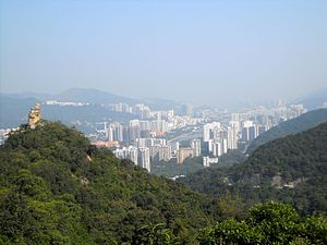
Sha Tin District
District in New Territories, Hong Kong
Distance: Approx. 298 meters
Latitude and longitude: 22.38715,114.19534
Sha Tin District is one of the 18 districts of Hong Kong. As one of the 9 districts located in the New Territories, it covers the areas of Sha Tin, Tai Wai, Ma On Shan, Fo Tan, Siu Lek Yuen, Kwun Yam Shan and Ma Liu Shui. The district is the most populous district in Hong Kong, with a population of 659,794 as per 2016 by-census, having a larger population than many states or dependencies including Iceland, Malta, Montenegro and Brunei.

Shing Mun River
River in Sha Tin, Hong Kong
Distance: Approx. 9 meters
Latitude and longitude: 22.384781,114.196529
The Shing Mun River (Chinese: 城門河) or Shing Mun River Channel (Chinese: 城門河道) is a river in Sha Tin, Hong Kong.

Baptist Lui Ming Choi Secondary School
Well-known Hong Kong school located at 11 Yuen Wo Rd, Sha Tin
Distance: Approx. 308 meters
Latitude and longitude: 22.385,114.19352778
Baptist Lui Ming Choi Secondary School (BLMCSS) (Chinese: 浸信會呂明才中學) is a well-known secondary school in Hong Kong located in 11 Yuen Wo Road, Hong Kong with a primary section, Baptist Lui Ming Choi Primary School. It was established in 1978 by the Baptist Convention of Hong Kong. Situated in the new town of Sha Tin, the school is a co-educational grammar school offering education at the first to sixth form levels education in Hong Kong.

Lek Yuen Estate
Public housing estate in Sha Tin, Hong Kong
Distance: Approx. 453 meters
Latitude and longitude: 22.385053,114.192115
Lek Yuen Estate (Chinese: 瀝源邨) is a public housing estate in Sha Tin, New Territories, Hong Kong. It is the first public housing estate in Sha Tin, built on the reclaimed land of Sha Tin Hoi, located near Wo Che Estate and MTR Sha Tin station. The estate consists of seven residential blocks completed in 1975.

Wo Che Estate
Public housing estate in Sha Tin, Hong Kong
Distance: Approx. 435 meters
Latitude and longitude: 22.38857,114.1959
Wo Che Estate (Chinese: 禾輋邨) is a public housing estate in Sha Tin, New Territories, Hong Kong. It is the second public housing estate in Sha Tin, built on the reclaimed land of Sha Tin Hoi, located near Fung Wo Estate, Lek Yuen Estate and Sha Tin Sports Ground. The estate consists of thirteen residential blocks completed in 1977, 1980 and 2003 respectively.
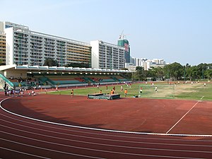
Sha Tin Sports Ground
Sports ground in Sha Tin, Hong Kong
Distance: Approx. 284 meters
Latitude and longitude: 22.38722222,114.19694444
Sha Tin Sports Ground is a multi-use stadium at 18 Yuen Wo Road, Sha Tin, Hong Kong. It is adjacent to the Shing Mun River. It is currently used mostly for football matches by Shatin Sports Association.

Sheng Kung Hui Tsang Shiu Tim Secondary School
Government-subsidised grammar school in Hong Kong
Distance: Approx. 280 meters
Latitude and longitude: 22.38694444,114.19527778
Sheng Kung Hui Tsang Shiu Tim Secondary School (Chinese: 聖公會曾肇添中學) is a school in Hong Kong that was founded in September 1978 by Sheng Kung Hui (Anglican), Diocese of Hong Kong and Macao. Located in Wo Che Estate, Shatin, it is an EMI school (grammar) subsidized by the Hong Kong Government.

Shatin Baptist Church
Church in Sha Tin, Hong Kong
Distance: Approx. 328 meters
Latitude and longitude: 22.3854,114.1934
Shatin Baptist Church (Chinese: 沙田浸信會) is a Baptist Evangelical multi-site megachurch based in Sha Tin in Hong Kong's New Territories. It is affiliated with the Baptist Convention of Hong Kong.
Shatin Anglican Church
Hong Kong Anglican church
Distance: Approx. 388 meters
Latitude and longitude: 22.3879,114.195
Shatin Anglican Church (Chinese: 沙田堂) is a Hong Kong Sheng Kung Hui (Anglican) church located in Shatin, New Territories, Hong Kong. It is a mission church under the Diocese of Eastern Kowloon. It was established in 1991 as a daughter church of St.

Yuen Chau Kok
Distance: Approx. 330 meters
Latitude and longitude: 22.383294,114.199319
Yuen Chau Kok (Chinese: 圓洲角) is an area in Sha Tin District, New Territories, Hong Kong, near Sha Tin Road and Prince of Wales Hospital and is within walking distance of City One station of the MTR Tuen Ma line. Before reclamation work in the 1970s, the area was an island in Tide Cove. The island was a major station for travellers and goods plying between Guangdong and Kowloon.
Private housing estates in Sha Tin District
Distance: Approx. 226 meters
Latitude and longitude: 22.38472222,114.19869444
The following is a non-exhaustive list of private housing estates in Sha Tin District, Hong Kong.

Tai Chung Kiu Road
Road in Sha Tin, Hong Kong
Distance: Approx. 311 meters
Latitude and longitude: 22.386028,114.199156
Tai Chung Kiu Road (Chinese: 大涌橋路) is a three-lane carriageway in Sha Tin District, New Territories, Hong Kong. It arises from the north-east at Shek Mun Interchange, traversing much of the Shing Mun River's south bank before terminating at the intersection between Lion Rock Tunnel Road and Che Kung Temple Road. Due to its proximity to the numerous public and private housing estates along the river, such as City One Shatin, Sha Kok Estate and Jat Min Chuen, Tai Chung Kiu Road serves as one of the major north–south thoroughfares in Sha Tin.
Weather in this IP's area
clear sky
29 Celsius
34 Celsius
28 Celsius
29 Celsius
1016 hPa
80 %
1016 hPa
1015 hPa
10000 meters
8.05 m/s
100 degree
8 %
06:21:03
17:54:59