Country:
 USA
USARegion:
City:
Latitude and Longitude:
Time Zone:
Postal Code:
IP information under different IP Channel
ip-api
Country
Region
City
ASN
Time Zone
ISP
Blacklist
Proxy
Latitude
Longitude
Postal
Route
IPinfo
Country
Region
City
ASN
Time Zone
ISP
Blacklist
Proxy
Latitude
Longitude
Postal
Route
MaxMind
Country
Region
City
ASN
Time Zone
ISP
Blacklist
Proxy
Latitude
Longitude
Postal
Route
Luminati
Country
USASN
Time Zone
America/Chicago
ISP
NTHL
Latitude
Longitude
Postal
db-ip
Country
Region
City
ASN
Time Zone
ISP
Blacklist
Proxy
Latitude
Longitude
Postal
Route
ipdata
Country
Region
City
ASN
Time Zone
ISP
Blacklist
Proxy
Latitude
Longitude
Postal
Route
Popular places and events near this IP address
Six Flags Hurricane Harbor SplashTown
Water park in Spring, Texas
Distance: Approx. 2648 meters
Latitude and longitude: 30.070167,-95.431935
Six Flags Hurricane Harbor Splashtown is a water park located north of Houston in Spring, Texas, United States.
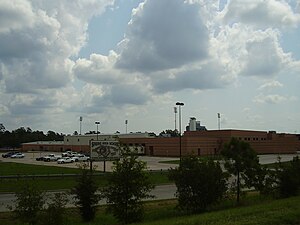
Carl Wunsche Sr. High School
Vocational school in Harris County, Texas
Distance: Approx. 3478 meters
Latitude and longitude: 30.07999,-95.42672
Carl Wunsche Sr. High School is a career academy high school in unincorporated Harris County, Texas. Wunsche is in the Spring Independent School District and serves grades 9 through 12.
Spring High School
Public school in Spring, Texas, United States
Distance: Approx. 3161 meters
Latitude and longitude: 30.05296,-95.42986
Spring High School is a public high school located in the Spring census-designated place in unincorporated Harris County, Texas, United States. Spring High School, which serves grades 9 through 12, is a part of the Spring Independent School District. Spring High School's mascot is the lion.
Hanna-Barbera Land
Former theme park near Houston, Texas
Distance: Approx. 2639 meters
Latitude and longitude: 30.07,-95.432
Hanna-Barbera Land was a theme park based on the cartoons of the Hanna-Barbera animation studio. It was located in the Spring, Texas, United States, north of Houston, and operated for the 1984 and 1985 seasons. After the park's closure following the 1985 season, the rides were sold and the land was reused as a water park, which is now operating as Six Flags Hurricane Harbor SplashTown.
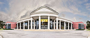
Klein Collins High School
Public high school in Klein, Texas, United States
Distance: Approx. 1941 meters
Latitude and longitude: 30.06111111,-95.47833333
Klein Collins High School is a public high school located at 20811 Ella Boulevard in unincorporated Harris County, Texas, United States. The school, with a Klein, Texas postal address, serves students in grades 9 through 12, as part of the Klein Independent School District. The 555,000-square-foot (51,600 m2) school sits on a 117.5-acre (0.476 km2) site.

Dekaney High School
Public school in Harris County, Texas, United States
Distance: Approx. 6529 meters
Latitude and longitude: 30.0175,-95.4209
Andy Dekaney High School is a public secondary school located at 22351 Imperial Valley Drive and Bammel Road in unincorporated Harris County, Texas, United States, with a ZIP code of 77073. Dekaney serves a small portion of Houston and sections of unincorporated Harris County. Dekaney serves the communities of Cranbrook, Glen Abbey, and Remington Ranch.
Bammel, Texas
Unincorporated community in Texas, US
Distance: Approx. 6589 meters
Latitude and longitude: 30.00694444,-95.46361111
Bammel is an unincorporated community in Harris County, Texas, United States. Bammel, eighteen miles north of downtown Houston at the intersection of Farm-to-Market Road 1960 (FM 1960) and Kuykendahl Road in north central Harris County, was established after the neighboring towns of Klein, Westfield, and Spring. It was named for Charles Bammel, a German Houstonian who built the Bammel and Kuehnle Merchandise store with his partner in 1915 and moved to the community for health reasons.
Jamie's House Charter School
State charter school in Harris County, Texas, United States
Distance: Approx. 5043 meters
Latitude and longitude: 30.02102,-95.45276
Jamie's House Charter School was a 6-12 state charter school in unincorporated northern Harris County, Texas.
Ponderosa Forest, Texas
Distance: Approx. 5240 meters
Latitude and longitude: 30.019,-95.462
Ponderosa Forest is a residential neighborhood in unincorporated northwestern Harris County, Texas, United States. It is located near Farm to Market Road 1960, also referred to as Cypress Creek Parkway.
Spring High School stabbing
Stabbing attack in Texas, United States
Distance: Approx. 3161 meters
Latitude and longitude: 30.05296,-95.42986
On September 4, 2013, one student was killed and three others were wounded in a stabbing attack at Spring High School in Spring, Texas, United States. A 17-year-old student, identified as Luis Alonzo Alfaro, was arrested and charged for the murder. In September 2014, Alfaro was convicted of manslaughter and sentenced to 20 years in prison.
Frassati Catholic High School
Private coeducational school in Spring, Texas, United States
Distance: Approx. 3858 meters
Latitude and longitude: 30.08638889,-95.49138889
Frassati Catholic High School is a private, Catholic coeducational secondary school located in unincorporated Harris County, Texas, near the Spring CDP and in Greater Houston. Frassati Catholic High School is administered by the Dominican Sisters of St. Cecilia Congregation from Nashville, Tennessee.
2014 Harris County shooting
Mass shooting in Harris County, Texas, US
Distance: Approx. 3253 meters
Latitude and longitude: 30.0408,-95.4419
On July 9, 2014, a mass shooting occurred in a home located in northern Harris County, Texas, near the Spring census-designated place, a suburban area of the Greater Houston area, leaving six family members dead, four children, and a lone survivor. Ronald Lee Haskell, 34, was apprehended after a standoff that lasted several hours. Haskell was related to the victims via his ex-wife.
Weather in this IP's area
scattered clouds
22 Celsius
22 Celsius
21 Celsius
24 Celsius
1017 hPa
65 %
1017 hPa
1012 hPa
10000 meters
5.14 m/s
20 degree
40 %
07:03:02
19:35:59