Country:
 USA
USARegion:
City:
Latitude and Longitude:
Time Zone:
Postal Code:
IP information under different IP Channel
ip-api
Country
Region
City
ASN
Time Zone
ISP
Blacklist
Proxy
Latitude
Longitude
Postal
Route
IPinfo
Country
Region
City
ASN
Time Zone
ISP
Blacklist
Proxy
Latitude
Longitude
Postal
Route
MaxMind
Country
Region
City
ASN
Time Zone
ISP
Blacklist
Proxy
Latitude
Longitude
Postal
Route
Luminati
Country
USRegion
nd
City
westfargo
ASN
Time Zone
America/Chicago
ISP
ENVENTIS
Latitude
Longitude
Postal
db-ip
Country
Region
City
ASN
Time Zone
ISP
Blacklist
Proxy
Latitude
Longitude
Postal
Route
ipdata
Country
Region
City
ASN
Time Zone
ISP
Blacklist
Proxy
Latitude
Longitude
Postal
Route
Popular places and events near this IP address

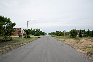
Briarwood, North Dakota
City in North Dakota, United States
Distance: Approx. 3073 meters
Latitude and longitude: 46.78694444,-96.79472222
Briarwood is a city in Cass County, North Dakota, United States. The population was 57 at the 2020 census. Briarwood was founded in 1973.
Frontier, North Dakota
City in North Dakota, United States
Distance: Approx. 565 meters
Latitude and longitude: 46.80027778,-96.83333333
Frontier is a city in Cass County, North Dakota, United States. The population was 195 at the 2020 census. Frontier is located south of the city of Fargo and is located roughly six miles southwest of that city's downtown.

Prairie Rose, North Dakota
City in North Dakota, United States
Distance: Approx. 2457 meters
Latitude and longitude: 46.81722222,-96.83527778
Prairie Rose is a city in Cass County, North Dakota, United States. The population was 56 at the 2020 census. The city is an enclave suburb of Fargo.
Osgood, North Dakota
Distance: Approx. 4865 meters
Latitude and longitude: 46.81361111,-96.89111111
Osgood was a city in Cass County, North Dakota in the United States. The city was located on the east side of the Sheyenne River, three miles south of West Fargo. Osgood was founded in 1884 as "Garfield" (named in honor of the recently assassinated President James A. Garfield).
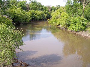
Wild Rice River (North Dakota)
River in North Dakota, United States
Distance: Approx. 5408 meters
Latitude and longitude: 46.75666667,-96.79
The Wild Rice River is a tributary of the Red River of the North, approximately 251 miles (404 km) long, in southeastern North Dakota in the United States. Via the Red River, Lake Winnipeg, and the Nelson River, it is part of the watershed of Hudson Bay. The Wild Rice River drains an area of 2,233 square miles (5,780 km2) in the Red River Valley region.

Shanley High School
School in North Dakota, US
Distance: Approx. 1285 meters
Latitude and longitude: 46.79888889,-96.81722222
Shanley High School (formerly Sacred Heart Academy), is a Catholic high school located in Fargo, North Dakota and operated by the Diocese of Fargo as part of the John Paul II Catholic Schools Network. As of 2014, it served approximately 314 students. Academics are strongly oriented towards college preparatory with approximately 99% of the student body continuing to either a 2 or 4-year degree program.
KFNW (AM)
Faith Radio station in West Fargo, North Dakota
Distance: Approx. 3867 meters
Latitude and longitude: 46.80166667,-96.88305556
KFNW, known on-air as Faith 1200 KFNW, or by the network name Faith Radio, is a radio station in Fargo, North Dakota (licensed to serve adjacent West Fargo), owned and operated by University of Northwestern - St. Paul and is a non-profit, listener-supported radio station relying on donations from the local community throughout the year. It broadcasts on 1200 AM, covering Fargo-Moorhead and surrounding areas in North Dakota.

Episcopal Diocese of North Dakota
Diocese of the Episcopal Church in the United States
Distance: Approx. 3616 meters
Latitude and longitude: 46.82611111,-96.81861111
The Episcopal Diocese of North Dakota is the diocese of the Episcopal Church in the United States of America with jurisdiction over the state of North Dakota plus Clay County, Minnesota. It has 19 congregations in North Dakota and one in Moorhead, Minnesota. It is in Province VI and its cathedral, Gethsemane Episcopal Cathedral, is in Fargo, as are the diocesan offices.

Davies High School
Public high school in North Dakota, United States
Distance: Approx. 2060 meters
Latitude and longitude: 46.78027778,-96.81722222
Davies High School is a public high school in Fargo, North Dakota, United States. It is part of the Fargo Public Schools district and was named after Ronald Davies, a former North Dakota based federal judge best known for ordering the integration of Little Rock Central High School during the civil rights crisis of the 1960s.
Gethsemane Episcopal Cathedral (Fargo, North Dakota)
Church in North Dakota, United States
Distance: Approx. 3619 meters
Latitude and longitude: 46.82615833,-96.81869167
Gethsemane Episcopal Cathedral is an Episcopal cathedral in Fargo, North Dakota, United States. It is the seat of the Diocese of North Dakota.
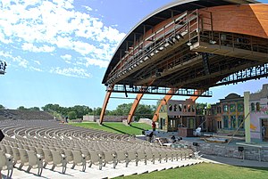
Bluestem Amphitheater
Distance: Approx. 3809 meters
Latitude and longitude: 46.818,-96.795927
Bluestem Center for the Arts is a 3,000 seat outdoor theater in Moorhead, Minnesota that exhibits performing arts and concerts. Since its opening, it has earned a national reputation as a premier contemporary amphitheater.

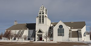
Sts. Anne and Joachim Catholic Church
Church in North Dakota, United States of America
Distance: Approx. 1446 meters
Latitude and longitude: 46.8025,-96.8175
Sts. Anne and Joachim is a Roman Catholic church located in Fargo, North Dakota. Planning for the church began in 1995 and was completed in 2010.
Weather in this IP's area
clear sky
21 Celsius
21 Celsius
20 Celsius
22 Celsius
1001 hPa
84 %
1001 hPa
970 hPa
10000 meters
5.14 m/s
170 degree
07:10:58
19:30:59