64.203.75.201 - IP Lookup: Free IP Address Lookup, Postal Code Lookup, IP Location Lookup, IP ASN, Public IP
Country:
 Canada
Region:
City:
Location:
Time Zone:
Postal Code:
ISP:
ASN:
language:
User-Agent:
Proxy IP:
Blacklist:
IP information under different IP Channel
ip-api
Country
Region
City
ASN
Time Zone
ISP
Blacklist
Proxy
Latitude
Longitude
Postal
Route
db-ip
Country
Region
City
ASN
Time Zone
ISP
Blacklist
Proxy
Latitude
Longitude
Postal
Route
IPinfo
Country
Region
City
ASN
Time Zone
ISP
Blacklist
Proxy
Latitude
Longitude
Postal
Route
IP2Location
64.203.75.201Country
caRegion
saskatchewan
City
regina
Time Zone
America/Regina
ISP
Language
User-Agent
Latitude
Longitude
Postal
ipdata
Country
Region
City
ASN
Time Zone
ISP
Blacklist
Proxy
Latitude
Longitude
Postal
Route
Popular places and events near this IP address

Taylor Field (Regina, Saskatchewan)
Former stadium in Regina, Saskatchewan, Canada
Distance: Approx. 314 meters
Latitude and longitude: 50.45262778,-104.62419167
Taylor Field, known in its latter years as Mosaic Stadium at Taylor Field for sponsorship reasons, was an open-air stadium located in Regina, Saskatchewan. It was the home field of the Canadian Football League's Saskatchewan Roughriders from 1936 until 2016, although a playing field existed at the site as early as 1910 and the team began playing there as early as 1921. Originally designed primarily to house baseball (with football being a secondary consideration) the stadium was converted to a football-only facility in 1966.

Regina Cyclone
1912 windstorm in Saskatchewan, Canada
Distance: Approx. 564 meters
Latitude and longitude: 50.448,-104.61461
The Regina Cyclone, or Regina tornado of 1912, was a tornado that devastated the city of Regina, Saskatchewan, Canada, on Sunday, June 30, 1912. It remains the deadliest tornado in Canadian history with a total of 28 fatalities and about 300 people injured. At about 4:50 p.m., green funnel clouds formed and touched down south of the city, tearing through the residential area between Wascana Lake and Victoria Avenue, and continuing through the downtown business district, rail yards, warehouse district, and northern residential area.

St. Paul's Cathedral (Regina, Saskatchewan)
Church in Saskatchewan, Canada
Distance: Approx. 419 meters
Latitude and longitude: 50.4491,-104.6161
St Paul's Anglican Cathedral is an historic church building located on the outskirts of Regina's central business district. Built as a parish church in 1894–1895, it became the pro-cathedral of the Anglican Diocese of Qu'Appelle in southern Saskatchewan, Canada, in 1944 when pro-cathedral status was removed from St Peter's, Qu'Appelle, in the eponymous former see city which had become moribund. In 1973, when it had become clear that the once-planned grand cathedral for Regina — at the corner of Broad Street and College Avenue — was no longer a feasible project, its status was raised to that of cathedral.

Holy Rosary Cathedral (Regina, Saskatchewan)
Church in Saskatchewan, Canada
Distance: Approx. 676 meters
Latitude and longitude: 50.445028,-104.626426
Holy Rosary Cathedral at 13th Avenue and Garnet Street in Regina, Saskatchewan, Canada, is the cathedral church of the Roman Catholic Archdiocese of Regina.

Victoria Park, Regina
Municipal park in Regina, Saskatchewan
Distance: Approx. 715 meters
Latitude and longitude: 50.44802222,-104.61227222
Victoria Park is a public park in the centre of downtown Regina, the capital of the Canadian province of Saskatchewan. The park is the size of two city blocks, bordered north and south by 12th Avenue and Victoria Avenue, and east and west by Scarth Street and Lorne Street. The centre of the park divides north and southbound Cornwall Street.

John A. Macdonald Memorial (Grandmaison)
Sculpture of John A. Macdonald by Sonia de Grandmaison and John Cullen Nugent
Distance: Approx. 730 meters
Latitude and longitude: 50.447547,-104.612346
The John A. Macdonald Memorial was a public sculpture in bronze of John A. Macdonald by Sonia de Grandmaison and John Cullen Nugent, formerly located at the south entrance to Victoria Park, Regina, Saskatchewan, Canada. In March 2021, Regina city council voted to remove the statue and it was removed in April 2021.
Roman Catholic Archdiocese of Regina
Catholic ecclesiastical territory
Distance: Approx. 664 meters
Latitude and longitude: 50.445,-104.626
The Roman Catholic Archdiocese of Regina (Latin: Archidioecesis Reginatensis) is a Roman Catholic archdiocese comprising the southern part of the Canadian province of Saskatchewan, as far north as the 30th township, or about 51°30' lat. The metropolitan province includes the suffragan dioceses of Prince Albert and Saskatoon. The seat of the diocese is in the city of Regina.

Regina Centre
Distance: Approx. 663 meters
Latitude and longitude: 50.456,-104.619
Regina Centre is a former provincial electoral division in the Canadian province of Saskatchewan, created in the redistribution prior to the 1967 election out of parts of Regina West and Regina North. It was abolished prior to the 2003 general election and is now part of Regina Elphinstone-Centre. It was the riding of Premier Allan Blakeney.

Queen Elizabeth II Court (Regina, Saskatchewan)
Office in Regina, Saskatchewan
Distance: Approx. 502 meters
Latitude and longitude: 50.44777778,-104.61583333
Queen Elizabeth II Court is the city block containing Regina City Hall, a 16-storey office tower in Regina, Saskatchewan, Canada. The city hall is built in the International Style. Opened in 1976, "[t]he construction manager was Poole Construction Limited and the architect, Joseph Pettick.

C.M. Fines Building
Office building in Regina, Canada
Distance: Approx. 594 meters
Latitude and longitude: 50.45055556,-104.61333333
The C.M. Fines Building is a 20-storey office tower located at 2260 11th Avenue in Regina, Saskatchewan, Canada. The building was completed in 1979. The building was designed by Joseph Pettick and features unusual energy-efficient reflective windows containing gold dust, giving the building its distinctive colour.

Knox-Metropolitan United Church (Regina, Saskatchewan)
Church in Regina, Saskatchewan
Distance: Approx. 610 meters
Latitude and longitude: 50.4475,-104.6143
Knox-Metropolitan United Church stands on Lorne Street at Victoria Avenue across from Victoria Park in downtown Regina, Saskatchewan, Canada.
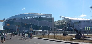
Mosaic Stadium
Football stadium in Regina, Saskatchewan
Distance: Approx. 805 meters
Latitude and longitude: 50.45055556,-104.63305556
Mosaic Stadium is an open-air stadium at REAL District in Regina, Saskatchewan. Announced on July 12, 2012, the stadium replaced Mosaic Stadium at Taylor Field as the home field of the Canadian Football League's Saskatchewan Roughriders. It was designed by HKS, Inc., in joint venture with B+H, the architects of record.
Weather in this IP's area
few clouds
-26 Celsius
-33 Celsius
-27 Celsius
-26 Celsius
1041 hPa
71 %
1041 hPa
962 hPa
10000 meters
8.23 m/s
310 degree
20 %