64.201.143.90 - IP Lookup: Free IP Address Lookup, Postal Code Lookup, IP Location Lookup, IP ASN, Public IP
Country:
Region:
City:
Location:
Time Zone:
Postal Code:
IP information under different IP Channel
ip-api
Country
Region
City
ASN
Time Zone
ISP
Blacklist
Proxy
Latitude
Longitude
Postal
Route
Luminati
Country
Region
tx
City
dallas
ASN
Time Zone
America/Chicago
ISP
US-TELEPACIFIC
Latitude
Longitude
Postal
IPinfo
Country
Region
City
ASN
Time Zone
ISP
Blacklist
Proxy
Latitude
Longitude
Postal
Route
IP2Location
64.201.143.90Country
Region
texas
City
dallas
Time Zone
America/Chicago
ISP
Language
User-Agent
Latitude
Longitude
Postal
db-ip
Country
Region
City
ASN
Time Zone
ISP
Blacklist
Proxy
Latitude
Longitude
Postal
Route
ipdata
Country
Region
City
ASN
Time Zone
ISP
Blacklist
Proxy
Latitude
Longitude
Postal
Route
Popular places and events near this IP address
University of Texas Southwestern Medical Center
Public academic health science center in Dallas, Texas
Distance: Approx. 1952 meters
Latitude and longitude: 32.8126058,-96.8384102
The University of Texas Southwestern Medical Center (UT Southwestern or UTSW) is a public academic health science center in Dallas, Texas. With approximately 23,000 employees, more than 3,000 full-time faculty, and nearly 4 million outpatient visits per year, UT Southwestern is the largest medical school in the University of Texas System and the State of Texas. UT Southwestern's operating budget in 2021 was more than US$4.1 billion, and is the largest medical institution in the Dallas–Fort Worth Metroplex (and therefore North Texas region), annually training about 3,800 medical, graduate, and health professions students, residents, and postdoctoral fellows.

Cathedral of Hope (Dallas)
LGBT Christian cathedral
Distance: Approx. 1194 meters
Latitude and longitude: 32.828466,-96.833056
The Cathedral of Hope (CoH), a member congregation of the United Church of Christ, is an historically and predominantly LGBTQ congregation located in the Oak Lawn area of Dallas, Texas, in the United States. The Dallas Cathedral of Hope is said to be the world's largest inclusive "liberal Christian church with a primary outreach to lesbian, gay, bisexual and transgender persons", with a membership of over 4,000 local members. The current building, built in 1993, is complemented with the 78-foot tall John Thomas Memorial Bell Wall commemorating HIV/AIDS victims.
Love Field, Dallas
Place in Texas, United States
Distance: Approx. 1025 meters
Latitude and longitude: 32.834,-96.855
Love Field is a neighborhood located in northwest Dallas, Texas (USA). It lies southwest of and is adjacent to Dallas Love Field Airport and is bounded by Denton Drive, Inwood Road, Harry Hines Boulevard, and Webb Chapel Extension. The neighborhood takes its name from Love Field Airport.

Frontiers of Flight Museum
Aviation museum in Dallas, Texas
Distance: Approx. 1786 meters
Latitude and longitude: 32.8424,-96.8353
The Frontiers of Flight Museum is an aerospace museum located in Dallas, Texas, founded in November 1988 by William E. Cooper, Kay Bailey Hutchison, and Jan Collmer. Originally located within a terminal at Dallas Love Field, the museum now occupies a 100,000-square-foot (9,300 m2) building at the southeast corner of Love Field on Lemmon Avenue. The museum is an affiliate within the Smithsonian Affiliations program.
Inwood/Love Field station
DART light rail station in Dallas, Texas
Distance: Approx. 1423 meters
Latitude and longitude: 32.821808,-96.833221
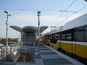
Inwood/Love Field station is a DART light rail station in Dallas, Texas. The elevated station is located at the intersection of Inwood Road and Denton Drive in the western end of the Oak Lawn neighborhood. The station is served by the Green Line and the Orange Line.
Southwestern Medical District/Parkland station
DART light rail station in Dallas, Texas
Distance: Approx. 2072 meters
Latitude and longitude: 32.813621,-96.833328
Southwestern Medical District/Parkland station is a DART light rail station in Dallas, Texas. It serves the Green Line and Orange Line. The station opened as part of the Green Line's expansion in December 2010.

Burbank station (DART)
DART light rail station in Dallas, Texas
Distance: Approx. 2139 meters
Latitude and longitude: 32.842689,-96.861854
Burbank station is a DART light rail station located near Dallas Love Field airport for service on the Green Line and Orange Line. The station opened as part of the Green Line's expansion in December 2010, and serves the headquarters for Southwest Airlines and an adjacent residential neighborhood. This station was originally proposed to serve the airport terminal directly with an underground station (much like Cityplace/Uptown station), but a 2004 study showed that costs would be well beyond acceptable levels and jeopardize a federal grant.

Texas Tech University Health Sciences Center at Dallas
Distance: Approx. 1011 meters
Latitude and longitude: 32.8207,-96.8414
Texas Tech University Health Sciences Center at Dallas (TTUHSC Dallas) is a branch campus of Texas Tech University Health Sciences Center (TTUHSC) located in Dallas, Texas. The TTUHSC School of Pharmacy and the School of Nursing are the only academic units to offer classes at the campus. TTUHSC Dallas is located adjacent to the Southwestern Medical District in Dallas, that includes institutions such as Children's Medical Center Dallas, Parkland Memorial Hospital, and the University of Texas Southwestern Medical Center.
Jetrail
Distance: Approx. 1006 meters
Latitude and longitude: 32.837592,-96.842467
Braniff Jetrail Fastpark System was a suspended monorail system that operated at Dallas Love Field in Dallas, Texas, United States, from April 18, 1970, until January 13, 1974. It was built by Stanray Corporation, Chicago, Illinois, for and operated by Braniff International Airways to transport passengers and their luggage from remote parking lots to the airport terminal. Jetrail was the world's first fully automated monorail transit system.

Center for BrainHealth
Research institute
Distance: Approx. 518 meters
Latitude and longitude: 32.82462,-96.847675
The Center for BrainHealth, part of The University of Texas at Dallas' school of Behavioral and Brain Sciences, is a research institute focused exclusively on brain health that combines brain research with clinical interventions. Founded by Dr. Sandra Bond Chapman in 1999, the Center for BrainHealth houses 125 researchers, postdoctoral research fellows, doctoral students, master's students, and research clinicians who work on 60 privately and federally funded research projects.

Dallas Love Field
Municipal airport in Dallas, Texas, United States
Distance: Approx. 2101 meters
Latitude and longitude: 32.84722222,-96.85166667
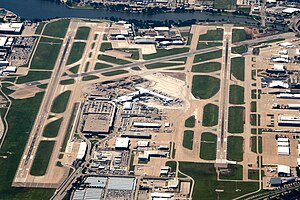
Dallas Love Field (IATA: DAL, ICAO: KDAL, FAA LID: DAL) is a city-owned public airport in the neighborhood of Love Field, 6 miles (9.7 km; 5.2 nmi) northwest of downtown Dallas, Texas. It was Dallas' main airport until 1974 when Dallas Fort Worth International Airport (DFW) opened. Love Field covers an area of 1,300 acres (530 ha) at an elevation of 487 feet (148 m) above mean sea level and has two runways.

William P. Clements Jr. University Hospital
Hospital in Texas, United States
Distance: Approx. 2110 meters
Latitude and longitude: 32.81111111,-96.83833333
William P. Clements Jr. University Hospital is a hospital in the Southwestern Medical District in Dallas, Texas, United States. It is one of the main teaching hospitals of the University of Texas Southwestern Medical Center.
Weather in this IP's area
clear sky
4 Celsius
-1 Celsius
3 Celsius
5 Celsius
1011 hPa
78 %
1011 hPa
992 hPa
10000 meters
6.69 m/s
10.8 m/s
170 degree

