Country:
Region:
City:
Latitude and Longitude:
Time Zone:
Postal Code:
IP information under different IP Channel
ip-api
Country
Region
City
ASN
Time Zone
ISP
Blacklist
Proxy
Latitude
Longitude
Postal
Route
Luminati
Country
Region
va
City
purcellville
ASN
Time Zone
America/New_York
ISP
CLADDED-GLASS-01
Latitude
Longitude
Postal
IPinfo
Country
Region
City
ASN
Time Zone
ISP
Blacklist
Proxy
Latitude
Longitude
Postal
Route
db-ip
Country
Region
City
ASN
Time Zone
ISP
Blacklist
Proxy
Latitude
Longitude
Postal
Route
ipdata
Country
Region
City
ASN
Time Zone
ISP
Blacklist
Proxy
Latitude
Longitude
Postal
Route
Popular places and events near this IP address

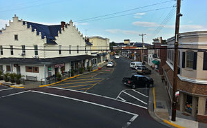
Purcellville, Virginia
Town in Virginia, US
Distance: Approx. 2120 meters
Latitude and longitude: 39.13444444,-77.71111111
Purcellville is a town in Loudoun County, Virginia. The population was 8,929 according to the 2020 census. Purcellville is the major population center for Western Loudoun and the Loudoun Valley.

Round Hill, Loudoun County, Virginia
Town in Virginia
Distance: Approx. 3162 meters
Latitude and longitude: 39.13361111,-77.77027778
Round Hill is a town in Loudoun County, Virginia, United States. Its population was 693 at the 2020 census. The town is located at the crossroads of Virginia Routes 7 and 719 (Woodgrove Road), approximately 50 miles (80 km) northwest of Washington, D.C. The town's name refers a hill two miles northeast of a 910-foot (280 m) hill used during the American Civil War as a signal post by both Confederate and Union troops.
Loudoun Valley High School
Public school in Purcellville, Virginia
Distance: Approx. 2803 meters
Latitude and longitude: 39.14033333,-77.70213889
Loudoun Valley High School (more commonly known as Valley) is a public secondary school in Purcellville, Virginia. It is part of Loudoun County Public Schools. Before the opening of Woodgrove High School in 2010, it was the sole high school for the western half of Loudoun County (which includes Purcellville, Hamilton, Round Hill, Lovettsville, Hillsboro, Middleburg, Philomont and Bluemont).
Woodgrove High School
Public secondary school in Purcellville, Virginia-
Distance: Approx. 1956 meters
Latitude and longitude: 39.15694444,-77.72861111
Woodgrove High School is a public secondary school in Purcellville, Virginia. It serves grades 9-12 for Loudoun County Public Schools.

Catoctin Creek Distilling Company
Distance: Approx. 1736 meters
Latitude and longitude: 39.13652778,-77.715
The Catoctin Creek Distilling Company ( kə-TOK-tən), which operates under the trade name of Catoctin Creek, is the first legal distillery in Loudoun County, Virginia, since prohibition. The distillery is a certified organic and kosher microdistillery in Purcellville, Virginia, that produces brandy, rye whiskey, and gin from local fruit, organic grain and Virginia wine.

Bush Tabernacle
Roller skating rink
Distance: Approx. 1827 meters
Latitude and longitude: 39.134052,-77.714885
The Bush Tabernacle Skating Rink and Event Venue is a roller skating rink and community center located in Purcellville, Virginia. The building is listed on the National Register of Historic Places. Built in 1903, the original structure was an amphitheater-style auditorium that hosted politicians, evangelists and performers.

Ketoctin Baptist Church
Historic church in Virginia, United States
Distance: Approx. 2333 meters
Latitude and longitude: 39.15722222,-77.75
Ketoctin Baptist Church, also known as Short Hill Church, is a historic Baptist church located at Round Hill, Loudoun County, Virginia. It is listed on both the U.S. National Register of Historic Places and the Virginia Landmarks Register.

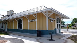
Purcellville Train Station
United States historic place
Distance: Approx. 1601 meters
Latitude and longitude: 39.13848,-77.71616
Purcellville Train Station is a historic railway station located in Purcellville, Loudoun County, Virginia. The station is adjacent to the Washington and Old Dominion Railroad Trail (W&OD Trail). The Southern Railway constructed the station in 1904.

Locust Grove (Purcellville, Virginia)
Historic house in Virginia, United States
Distance: Approx. 1795 meters
Latitude and longitude: 39.13305556,-77.71583333
Locust Grove is a historic home located at Purcellville, Loudoun County, Virginia. The house was built in two phases, one before 1817 and another in 1837. The original section is a single-pile, two-story structure built of fieldstone with a side gable roof in the Federal style.
Rich Bottom Farm
Historic house in Virginia, United States
Distance: Approx. 1090 meters
Latitude and longitude: 39.14972222,-77.73305556
Rich Bottom Farm is a historic home located near Purcellville, Loudoun County, Virginia. The house was built in three sections between about 1780 and 1820. It is a two-story, limestone and brick structure with a side gable roof in the Federal style.
Round Hill Historic District (Round Hill, Virginia)
Historic district in Virginia, United States
Distance: Approx. 3045 meters
Latitude and longitude: 39.13277778,-77.76861111
Round Hill Historic District is a national historic district located at Round Hill, Loudoun County, Virginia. It encompasses 204 contributing buildings, 1 contributing site, and 1 contributing structure in the town of Round Hill. It includes a variety of residential, commercial, and institutional buildings, with the majority built between 1880 and 1920.
The Tabernacle-Fireman's Field
Historic meeting site in Virginia
Distance: Approx. 1839 meters
Latitude and longitude: 39.13305556,-77.71527778
The Tabernacle-Fireman's Field is a historic meeting site and picnic grounds located at Purcellville, Loudoun County, Virginia, US. The property includes the Bush Meeting Taberbacle. It is an eight-sided, frame building measuring approximately 80 feet by 160 feet. It was originally built to house the "Bush Meetings" that were conducted by the Prohibition and Evangelical Association of Loudoun County, Virginia.
Weather in this IP's area
overcast clouds
7 Celsius
6 Celsius
6 Celsius
9 Celsius
1023 hPa
74 %
1023 hPa
1002 hPa
10000 meters
1.34 m/s
3.58 m/s
108 degree
100 %
06:53:41
16:57:27


