Country:
 USA
USARegion:
City:
Latitude and Longitude:
Time Zone:
Postal Code:
IP information under different IP Channel
ip-api
Country
Region
City
ASN
Time Zone
ISP
Blacklist
Proxy
Latitude
Longitude
Postal
Route
IPinfo
Country
Region
City
ASN
Time Zone
ISP
Blacklist
Proxy
Latitude
Longitude
Postal
Route
MaxMind
Country
Region
City
ASN
Time Zone
ISP
Blacklist
Proxy
Latitude
Longitude
Postal
Route
Luminati
Country
USRegion
mi
City
battlecreek
ASN
Time Zone
America/Detroit
ISP
CTSTELECOM
Latitude
Longitude
Postal
db-ip
Country
Region
City
ASN
Time Zone
ISP
Blacklist
Proxy
Latitude
Longitude
Postal
Route
ipdata
Country
Region
City
ASN
Time Zone
ISP
Blacklist
Proxy
Latitude
Longitude
Postal
Route
Popular places and events near this IP address

Calhoun County, Michigan
County in Michigan, United States
Distance: Approx. 957 meters
Latitude and longitude: 42.25,-85
Calhoun County is a county in the U.S. state of Michigan. As of the 2020 Census, the population was 134,310. The county seat is Marshall.
Marshall Township, Michigan
Township in Michigan, United States
Distance: Approx. 4552 meters
Latitude and longitude: 42.28416667,-85
Marshall Township is a civil township of Calhoun County in the U.S. state of Michigan. It is part of the Battle Creek, Michigan Metropolitan Statistical Area. The population was 3,157 at the 2020 census.

Marshall Historic District
Historic district in Michigan, United States
Distance: Approx. 4998 meters
Latitude and longitude: 42.27416667,-84.96333333
The Marshall Historic District is a National Historic Landmark District that encompasses a significant portion of the central residential and commercial area of Marshall, Michigan. The district is nationally significant for the remarkably unified and well-preserved street plan, architecture, and public infrastructure, one of the largest such concentrations in the nation. It was designated a National Historic Landmark in 1991.
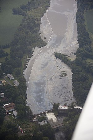
Kalamazoo River oil spill
2010 oil spill in Calhoun County, Michigan, US
Distance: Approx. 1957 meters
Latitude and longitude: 42.25743,-84.99307
The Kalamazoo River oil spill occurred in July 2010 when a pipeline operated by Enbridge (Line 6B) burst and flowed into Talmadge Creek, a tributary of the Kalamazoo River near Marshall, Michigan. A 6-foot (1.8 m) break in the pipeline resulted in one of the largest inland oil spills in U.S. history (the largest was the 1991 spill near Grand Rapids, Minnesota). The pipeline carries diluted bitumen (dilbit), a heavy crude oil from Canada's Athabasca oil sands to the United States.
Talmadge Creek
River in the United States of America
Distance: Approx. 1834 meters
Latitude and longitude: 42.25726,-84.99525
Talmadge Creek is a tributary of the Kalamazoo River. It is located in Calhoun County, Michigan, near the county seat of Marshall.

Governor's Mansion (Marshall, Michigan)
Historic house in Michigan, United States
Distance: Approx. 5002 meters
Latitude and longitude: 42.265,-84.95444444
The Governor's Mansion at 621 S. Marshall Ave. in Marshall, Michigan is a historic house built in 1839 with elements of Greek Revival architecture. It is also known as Governor's Mansion Museum.

Honolulu House
Historic house in Michigan, United States
Distance: Approx. 4814 meters
Latitude and longitude: 42.27269444,-84.96455556
Honolulu House, also known as the Abner Pratt House, is a historic home in Marshall, Michigan, built in 1860 as a Hawaiian-inspired house with Italianate and Gothic Revival styles.

Harold C. Brooks House
United States historic place
Distance: Approx. 4986 meters
Latitude and longitude: 42.27444444,-84.96388889
The Harold C. Brooks House, also known as the Jabez S. Fitch House or the Charles T. Gorham House, is a historic home located at 310 N. Kalamazoo Avenue in Marshall, Michigan. It was listed on the National Register of Historic Places in 1970, with the surrounding grounds added in 1984.

Joy House (Marshall, Michigan)
United States historic place
Distance: Approx. 4944 meters
Latitude and longitude: 42.27388889,-84.96388889
The Joy House, also known as the Benedict-Joy House, is a single-family home located at 224 North Kalamazoo Avenue in Marshall, Michigan. It was listed on the National Register of Historic Places in 1972.

Stonehall (Marshall, Michigan)
United States historic place
Distance: Approx. 4932 meters
Latitude and longitude: 42.27416667,-84.96444444
Stonehall, also known as the Andrew L. Hayes House, is a single-family home located at 303 North Kalamazoo Street in Marshall, Michigan. It was listed on the National Register of Historic Places in 1972. It is often cited as one of the finest examples of Greek Revival architecture in Michigan.

National House (Marshall, Michigan)
United States historic place
Distance: Approx. 4731 meters
Latitude and longitude: 42.27194444,-84.965
The National House is a hotel located at 102 South Parkview in Marshall, Michigan. It was listed on the National Register of Historic Places in 1978. It is thought to be the first brick building constructed in Calhoun County.

William Prindle Livery Stable
United States historic place
Distance: Approx. 4759 meters
Latitude and longitude: 42.27138889,-84.96388889
The William Prindle Livery Stable is a farmer stable located at 323 West Michigan Avenue in Marshall, Michigan. It was listed on the National Register of Historic Places in 1982. It currently serves as the city hall for Marshall.
Weather in this IP's area
clear sky
17 Celsius
16 Celsius
16 Celsius
18 Celsius
1030 hPa
31 %
1030 hPa
996 hPa
10000 meters
2.06 m/s
170 degree
07:56:37
18:53:12