64.194.134.207 - IP Lookup: Free IP Address Lookup, Postal Code Lookup, IP Location Lookup, IP ASN, Public IP
Country:
Region:
City:
Location:
Time Zone:
Postal Code:
ISP:
ASN:
language:
User-Agent:
Proxy IP:
Blacklist:
IP information under different IP Channel
ip-api
Country
Region
City
ASN
Time Zone
ISP
Blacklist
Proxy
Latitude
Longitude
Postal
Route
db-ip
Country
Region
City
ASN
Time Zone
ISP
Blacklist
Proxy
Latitude
Longitude
Postal
Route
IPinfo
Country
Region
City
ASN
Time Zone
ISP
Blacklist
Proxy
Latitude
Longitude
Postal
Route
IP2Location
64.194.134.207Country
Region
california
City
madera
Time Zone
America/Los_Angeles
ISP
Language
User-Agent
Latitude
Longitude
Postal
ipdata
Country
Region
City
ASN
Time Zone
ISP
Blacklist
Proxy
Latitude
Longitude
Postal
Route
Popular places and events near this IP address

Madera, California
City in California, United States
Distance: Approx. 15 meters
Latitude and longitude: 36.96138889,-120.06083333
Madera (Spanish for "Wood") is a city and county seat of Madera County, located in the San Joaquin Valley of California. As of the 2020 United States census, the city's population was 66,224.

Parksdale, California
Census-designated place in California, United States
Distance: Approx. 3697 meters
Latitude and longitude: 36.94722222,-120.02305556
Parksdale is a census-designated place (CDP) in Madera County, California, United States. It is part of the Madera Metropolitan Statistical Area. The population was 3,234 at the 2020 census, up from 2,621 in 2010.

Parkwood, California
Census-designated place in California, United States
Distance: Approx. 4080 meters
Latitude and longitude: 36.92694444,-120.04472222
Parkwood is a census-designated place (CDP) in Madera County, California, United States. It is part of the Madera Metropolitan Statistical Area. The population was 2,307 at the 2020 census.
Madera Municipal Airport
Airport in Madera, California
Distance: Approx. 5520 meters
Latitude and longitude: 36.98861111,-120.1125
Madera Municipal Airport (IATA: MAE, ICAO: KMAE, FAA LID: MAE) is three miles (4.8 km) northwest of Madera, in Madera County, California. The FAA's National Plan of Integrated Airport Systems for 2011–2015 categorized it as a general aviation facility.
Madera High School
High school in Madera, California
Distance: Approx. 912 meters
Latitude and longitude: 36.9541,-120.0656
Madera High School is the first school and original high school in the central San Joaquin Valley city of Madera, California, serving students since 1894. The school colors are royal blue & white and its mascot is the coyote.
Madera South High School
School in Madera, Madera County, California, United States
Distance: Approx. 2503 meters
Latitude and longitude: 36.93931944,-120.06660556
Madera South High School (also known as Madera South, Madera South High or MSHS) is a high school located in Madera, California and is part of the Madera Unified School District. Previously functioning as the second campus of the town's other high school, Madera High, the school officially became Madera's second official high school in August 2006.
Borden, California
Unincorporated community in California, United States
Distance: Approx. 4616 meters
Latitude and longitude: 36.93,-120.02666667
Borden (formerly, Alabama Settlement and Arcola) is an unincorporated community in Madera County, California. It is located on the Southern Pacific Railroad 3 miles (4.8 km) southeast of Madera, at an elevation of 272 feet (83 m). The first settlers came from Alabama in 1858, whence its original name.

Madera County Courthouse
Historic government building in California, United States
Distance: Approx. 207 meters
Latitude and longitude: 36.95944444,-120.06083333
The Madera County Courthouse is the former county courthouse of Madera County, California. The courthouse is located at 210 W. Yosemite Ave. in Madera.
Madera Community Hospital
Hospital in California, United States
Distance: Approx. 2389 meters
Latitude and longitude: 36.944,-120.0448
Madera Community Hospital is a not-for-profit community health resource and is not associated with any other hospital or health system. The hospital is locally governed by a board of trustees which provides governance and oversight. The board is composed of over a dozen community and business leaders.

Storey station
Railway station in California, the United States of America
Distance: Approx. 3933 meters
Latitude and longitude: 36.97611111,-120.02055556
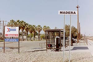
Storey (known as Madera by Amtrak) was an unstaffed train station located in the unincorporated community of Storey, and about 1 mile (1.6 km) southeast of the Fresno River, in Madera County, California, United States. Just prior to its closure in November 2010 and replacement by the new Madera station, this station was served by Amtrak's (the National Railroad Passenger Corporation) San Joaquin. Prior to Amtrak, this station was also previously served by Atchison, Topeka and Santa Fe Railroad's (ATSF) San Francisco Chief and its Oakland-Barstow Line.

Fresno River Viaduct
Rail bridge in Fresno, California, USA
Distance: Approx. 3706 meters
Latitude and longitude: 36.983069,-120.029177
The Fresno River Viaduct is a bridge to carry California High-Speed Rail (CAHSR) over Route 145, the Fresno River, and Raymond Road in Madera County, California. It was completed in 2018, the first permanent structure built for CAHSR. The site is just east of the city limits of Madera, California, about 20 miles northwest of the planned Fresno high-speed rail station and about 10 miles southeast of the planned Chowchilla Wye. Because the site is downstream from the John Franchi Diversion Dam, the riverbed is normally dry unless heavy rains cause the dam to overtop.
Madera County Superior Court
California superior court with jurisdiction over Madera County
Distance: Approx. 278 meters
Latitude and longitude: 36.9588,-120.06069
The Superior Court of California, County of Madera, also known as the Madera County Superior Court or Madera Superior Court, is the California superior court with jurisdiction over Madera County.
Weather in this IP's area
clear sky
14 Celsius
12 Celsius
14 Celsius
14 Celsius
1023 hPa
47 %
1023 hPa
1012 hPa
10000 meters
1.6 m/s
1.39 m/s
289 degree
3 %