64.184.32.126 - IP Lookup: Free IP Address Lookup, Postal Code Lookup, IP Location Lookup, IP ASN, Public IP
Country:
 USA
USARegion:
City:
Location:
Time Zone:
Postal Code:
ISP:
ASN:
language:
User-Agent:
Proxy IP:
Blacklist:
IP information under different IP Channel
ip-api
Country
Region
City
ASN
Time Zone
ISP
Blacklist
Proxy
Latitude
Longitude
Postal
Route
db-ip
Country
Region
City
ASN
Time Zone
ISP
Blacklist
Proxy
Latitude
Longitude
Postal
Route
IPinfo
Country
Region
City
ASN
Time Zone
ISP
Blacklist
Proxy
Latitude
Longitude
Postal
Route
IP2Location
64.184.32.126Country
usRegion
indiana
City
ligonier
Time Zone
America/Indiana/Indianapolis
ISP
Language
User-Agent
Latitude
Longitude
Postal
ipdata
Country
Region
City
ASN
Time Zone
ISP
Blacklist
Proxy
Latitude
Longitude
Postal
Route
Popular places and events near this IP address
Cromwell, Indiana
Town in Indiana, United States
Distance: Approx. 7042 meters
Latitude and longitude: 41.40333333,-85.61416667
Cromwell is a town in Sparta Township, Noble County, in the U.S. state of Indiana. The population was 512 at the 2010 census.
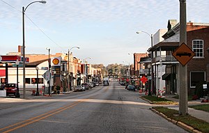
Ligonier, Indiana
City in Indiana, United States
Distance: Approx. 380 meters
Latitude and longitude: 41.4625,-85.59472222
Ligonier is a city in Perry Township, Noble County, in the U.S. state of Indiana. The population was 4,568 at the 2020 census.

Perry Township, Noble County, Indiana
Township in Indiana, United States
Distance: Approx. 2305 meters
Latitude and longitude: 41.48444444,-85.59583333
Perry Township is one of thirteen townships in Noble County, Indiana. As of the 2020 census, its population was 6,900 (up from 6,761 at 2010) and it contained 2,435 housing units.

Sparta Township, Noble County, Indiana
Township in Indiana, United States
Distance: Approx. 7633 meters
Latitude and longitude: 41.39555556,-85.59333333
Sparta Township is one of thirteen townships in Noble County, Indiana. As of the 2020 census, its population was 2,776 (down from 2,924 at 2010) and it contained 1,128 housing units.

Kimmell, Indiana
Census-designated place in Indiana, United States
Distance: Approx. 8456 meters
Latitude and longitude: 41.395,-85.54861111
Kimmell is an unincorporated census-designated place in Sparta Township, Noble County, in the U.S. state of Indiana.

West Noble High School
Public high school in Ligonier, Noble County, Indiana, United States
Distance: Approx. 4328 meters
Latitude and longitude: 41.425858,-85.581373
West Noble High School is a public high school in Ligonier, Indiana. The West Noble teams are referred to as the Chargers.

Jacob Straus House
Historic house in Indiana, United States
Distance: Approx. 105 meters
Latitude and longitude: 41.46416667,-85.58944444
Jacob Straus House, also known as the Louis Levy House, is a historic home located at Ligonier, Noble County, Indiana. It was built in 1898–1899, and is a two-story, frame dwelling with Neoclassical and Colonial Revival style design elements. It has a truncated hipped roof with dormers.

Ahavas Shalom Reform Temple
Historic synagogue in Indiana, United States
Distance: Approx. 310 meters
Latitude and longitude: 41.46166667,-85.58888889
Ahavas Shalom Reform Temple (originally, Ahavath Scholom, also Ahavath Sholom, "Lovers of Peace" or "Peace Loving")) is an historic former Reform Jewish synagogue building located at 503 Main Street, in Ligonier, Noble County, Indiana, in the United States. Built in 1889, the building was added to the National Register of Historic Places in 1983 as a contributing property within the Ligonier Historic District. The building was variously used as a synagogue, a church, a history museum, and, since 2019, has been used as a private residence.

Stone's Trace
Historic house in Indiana, United States
Distance: Approx. 4215 meters
Latitude and longitude: 41.42638889,-85.58611111
Stone's Trace is a historic site located in Sparta Township, Noble County, Indiana. The site includes four contributing buildings. Stone's Tavern was built in 1839, and is a two-story, five-bay, Federal style heavy timber frame dwelling.
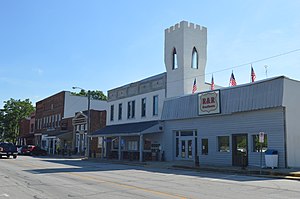
Ligonier Historic District (Ligonier, Indiana)
Historic district in Indiana, United States
Distance: Approx. 151 meters
Latitude and longitude: 41.46277778,-85.59111111
Ligonier Historic District is a national historic district located in Ligonier, Noble County, Indiana. The district encompasses 253 contributing buildings and two contributing objects in Ligonier. It was developed between about 1835 and 1937, and includes notable examples of Italianate, Queen Anne, Gothic Revival, Classical Revival, and Bungalow / American Craftsman style architecture.
Cromwell Historic District
Historic district in Indiana, United States
Distance: Approx. 7168 meters
Latitude and longitude: 41.40222222,-85.61444444
Cromwell Historic District is a national historic district located at Cromwell, Noble County, Indiana. The district encompasses 33 contributing buildings in the central business district and surrounding residential sections of Cromwell. It developed between about 1875 and 1953, and includes notable examples of Italianate, Queen Anne, Classical Revival, Tudor Revival, and Bungalow / American Craftsman style architecture.
Grismore, Indiana
Unincorporated community in Indiana, United States
Distance: Approx. 5074 meters
Latitude and longitude: 41.49555556,-85.63472222
Grismore is an unincorporated community in Perry Township, Noble County, in the U.S. state of Indiana.
Weather in this IP's area
overcast clouds
-4 Celsius
-4 Celsius
-5 Celsius
-4 Celsius
1028 hPa
80 %
1028 hPa
993 hPa
10000 meters
100 %