Country:
 USA
USARegion:
City:
Latitude and Longitude:
Time Zone:
Postal Code:
IP information under different IP Channel
ip-api
Country
Region
City
ASN
Time Zone
ISP
Blacklist
Proxy
Latitude
Longitude
Postal
Route
IPinfo
Country
Region
City
ASN
Time Zone
ISP
Blacklist
Proxy
Latitude
Longitude
Postal
Route
MaxMind
Country
Region
City
ASN
Time Zone
ISP
Blacklist
Proxy
Latitude
Longitude
Postal
Route
Luminati
Country
USASN
Time Zone
America/Chicago
ISP
NOANET-WA
Latitude
Longitude
Postal
db-ip
Country
Region
City
ASN
Time Zone
ISP
Blacklist
Proxy
Latitude
Longitude
Postal
Route
ipdata
Country
Region
City
ASN
Time Zone
ISP
Blacklist
Proxy
Latitude
Longitude
Postal
Route
Popular places and events near this IP address
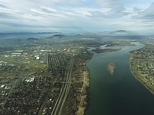
Tri-Cities, Washington
Place in Washington, United States
Distance: Approx. 2674 meters
Latitude and longitude: 46.22361111,-119.13583333
The Tri-Cities are three closely linked cities (Kennewick, Pasco, and Richland) at the confluence of the Yakima, Snake, and Columbia Rivers in the Columbia Basin of Eastern Washington. The cities border one another, making the Tri-Cities seem like one uninterrupted mid-sized city. The three cities function as the center of the Tri-Cities metropolitan area, which consists of Benton and Franklin counties.

Kennewick Man
Ancient skeleton of Indigenous American man
Distance: Approx. 2965 meters
Latitude and longitude: 46.22305556,-119.14333333
Kennewick Man or Ancient One was a Native American man who lived during the early Holocene, whose skeletal remains were found washed out on a bank of the Columbia River in Kennewick, Washington, on July 28, 1996. Radiocarbon tests show the man lived about 8,400 to 8,690 years Before Present, making his skeleton one of the most complete ever found this old in the Americas, and thus of high scientific interest for understanding the peopling of the Americas. The discovery precipitated a nearly twenty-year-long dispute.

Cable Bridge
Bridge in Pasco–Kennewick, Washington
Distance: Approx. 2033 meters
Latitude and longitude: 46.21840278,-119.10381389
The Cable Bridge, officially called the Ed Hendler Bridge and sometimes called the Intercity Bridge, spans the Columbia River between Pasco and Kennewick in southeastern Washington as State Route 397. It was constructed in 1978 and replaced the Pasco–Kennewick Bridge, an earlier span built in 1922 and demolished in 1990. The bridge is one of seven major bridge structures in the Tri-Cities area.
Kennewick High School
Public school in Kennewick, Washington, United States
Distance: Approx. 485 meters
Latitude and longitude: 46.204017,-119.124116
Kennewick High School is a public high school located in eastern Kennewick, Washington. It was founded in 1904 to serve the educational needs of the new city of Kennewick. It is one of only a few schools to have its music department honored with the title of "Grammy Signature School".
Kennewick School District
School district in Kennewick, Washington
Distance: Approx. 1196 meters
Latitude and longitude: 46.21277778,-119.12444444
Kennewick School District # 17 is the largest employer in the city of Kennewick, Washington. The school district runs 17 elementary schools, five middle schools, and seven high schools. The school district's superintendent, Traci Pierce, has been serving since January 2020.
Tri-City Herald
Newspaper in Kennewick, Washington
Distance: Approx. 899 meters
Latitude and longitude: 46.21011667,-119.12351111
The Tri-City Herald is a daily newspaper based in Kennewick, Washington, United States. Owned by The McClatchy Company, the newspaper serves southeastern Washington state, including the three cities of Kennewick, Pasco and Richland (which are collectively known as the Tri-Cities). The Herald also serves the smaller cities of Benton City, Connell, Prosser and West Richland.
Blue Bridge (Washington)
Four-lane arch-truss bridge
Distance: Approx. 2801 meters
Latitude and longitude: 46.22497778,-119.1357
The Blue Bridge (officially named the Pioneer Memorial Bridge) is a four-lane arch-truss bridge connecting Pasco, Washington to Kennewick, Washington. U.S. Route 395 crosses the Columbia River via this bridge. The name comes from the blue paint used on the truss superstructure, with white paint on the suspension beams.
Pasco School District (Washington)
Public school system in Washington, United States
Distance: Approx. 3046 meters
Latitude and longitude: 46.22833333,-119.10305556
Pasco School District No. 1 (PSD) is a public school district in Pasco, Washington, United States, part of the Tri-Cities area. It serves over 18,500 K–12 students in the city of Pasco and surrounding parts of unincorporated Franklin County.
KFLD
Radio station in Pasco, Washington
Distance: Approx. 2849 meters
Latitude and longitude: 46.22805556,-119.12555556
KFLD (870 AM) is a radio station broadcasting a news/talk format. Licensed to Pasco, Washington, United States, the station serves the Tri-Cities area. The station is currently owned by Townsquare Media and features programming from Fox News Radio, Compass Media Networks, Salem Radio Network, and Westwood One.

Pasco–Kennewick Bridge (1922)
Bridge in Washington, U.S.
Distance: Approx. 2033 meters
Latitude and longitude: 46.21840278,-119.10381389
The Pasco–Kennewick Bridge or Benton–Franklin Inter-County Bridge, known locally as the Blue Bridge, was a steel cantilever truss bridge in the northwest United States. It crossed the Columbia River in central Washington, connecting Pasco and Kennewick, two of the Tri-Cities. Succeeded by the Cable Bridge in 1978, it was demolished in 1990.

Columbia Park (Tri-Cities)
Public park in Washington, US
Distance: Approx. 2807 meters
Latitude and longitude: 46.22034722,-119.14445278
Columbia Park is a public park located in Benton County, Washington, United States. The park comprises the 400-acre (160 ha) Columbia Park East in Kennewick, and the adjacent 50-acre (20 ha) Columbia Park West in Richland. Together, the parks function as a single 450-acre (180 ha) park with 4.5 miles (7.2 km) of shoreline along the Columbia River.

Clover Island
Distance: Approx. 1649 meters
Latitude and longitude: 46.217,-119.111
Clover Island is a small island in the Columbia River located between the Blue Bridge and the Cable Bridge in Kennewick, Washington. It is roughly 2,400 feet (730 m) long, 700 feet (210 m) wide and has an area of 16 acres (6.5 ha). The island is owned by the Port of Kennewick.
Weather in this IP's area
clear sky
11 Celsius
10 Celsius
9 Celsius
12 Celsius
1020 hPa
67 %
1020 hPa
1006 hPa
10000 meters
6.69 m/s
230 degree
07:22:29
17:59:11