64.183.130.57 - IP Lookup: Free IP Address Lookup, Postal Code Lookup, IP Location Lookup, IP ASN, Public IP
Country:
Region:
City:
Location:
Time Zone:
Postal Code:
IP information under different IP Channel
ip-api
Country
Region
City
ASN
Time Zone
ISP
Blacklist
Proxy
Latitude
Longitude
Postal
Route
Luminati
Country
Region
al
City
enterprise
ASN
Time Zone
America/Chicago
ISP
TWC-11955-ATLANTA
Latitude
Longitude
Postal
IPinfo
Country
Region
City
ASN
Time Zone
ISP
Blacklist
Proxy
Latitude
Longitude
Postal
Route
IP2Location
64.183.130.57Country
Region
alabama
City
enterprise
Time Zone
America/Chicago
ISP
Language
User-Agent
Latitude
Longitude
Postal
db-ip
Country
Region
City
ASN
Time Zone
ISP
Blacklist
Proxy
Latitude
Longitude
Postal
Route
ipdata
Country
Region
City
ASN
Time Zone
ISP
Blacklist
Proxy
Latitude
Longitude
Postal
Route
Popular places and events near this IP address

Enterprise, Alabama
City in Coffee County, Alabama, US
Distance: Approx. 212 meters
Latitude and longitude: 31.3275,-85.84444444
Enterprise is a city in the southeastern part of Coffee County and the southwestern part of Dale County in Southeastern Alabama, United States. Its population was 28,711 at the 2020 census. Enterprise is the primary city of the Enterprise micropolitan statistical area (with the portion of the city in Dale County part of the Ozark micropolitan statistical area).

New Brockton, Alabama
Town in Alabama, United States
Distance: Approx. 9782 meters
Latitude and longitude: 31.381138,-85.924339
New Brockton is a town in Coffee County, Alabama, United States. At the 2020 census, the population was 1,428. The community was named for Huey E. Brock, a settler who came to the region in 1871.

Level Plains, Alabama
City in Alabama, United States
Distance: Approx. 7470 meters
Latitude and longitude: 31.313659,-85.767307
Level Plains is a small town in Dale County, Alabama, United States. At the 2020 census, the population was 1,825. It is part of the Ozark micropolitan statistical area.

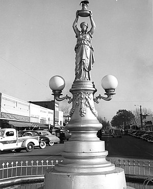
Boll Weevil Monument
United States historic place
Distance: Approx. 1532 meters
Latitude and longitude: 31.31444444,-85.85402778
The Boll Weevil Monument in downtown Enterprise, Alabama, United States, is a prominent landmark and tribute erected by the citizens of Enterprise in 1919 to show their appreciation to an insect, the boll weevil, for its profound influence on the area's agriculture and economy. Hailing the beetle as a "herald of prosperity," it stands as the world's first monument built to honor an agricultural pest. The Monument consists of a statue of a woman holding a pedestal with a boll weevil perched on top.

Enterprise Municipal Airport (Alabama)
Public-use airport in Enterprise, Alabama
Distance: Approx. 5982 meters
Latitude and longitude: 31.29972222,-85.89972222
Enterprise Municipal Airport (IATA: ETS, ICAO: KEDN, FAA LID: EDN) is a city-owned, public-use airport located three nautical miles (6 km) west of the central business district of Enterprise, a city in Coffee County, Alabama, United States. It is included in the National Plan of Integrated Airport Systems for 2011–2015, which categorized it as a general aviation facility. This airport is assigned a three-letter location identifier of EDN by the Federal Aviation Administration, but the International Air Transport Association (IATA) airport code is ETS. An EF4 tornado impacted near this area on March 1, 2007 before destroying the high school.

Enterprise High School (Alabama)
Public school in Enterprise, Alabama, United States
Distance: Approx. 860 meters
Latitude and longitude: 31.32384,-85.85341
Enterprise High School is a 7A public high school at 1801 Boll Weevil Circle in Enterprise, Coffee County, Alabama, USA, in the Enterprise City School District. The school houses grades 9-12. Enterprise City is one of three municipal school systems that take on-post Fort Novosel families at the secondary level.
Enterprise State Community College
Public college in Enterprise, Alabama, US
Distance: Approx. 3156 meters
Latitude and longitude: 31.298,-85.837
Enterprise State Community College is a public community college in Enterprise, Alabama. It was created by the Alabama State Board of Education in February 2003 by reorganizing Enterprise State Junior College to include the Alabama Aviation Centers at Ozark and Mobile. In December 2009, the Alabama State Board of Education approved a name change for the college to Enterprise State Community College with a marketing name for the aviation programs as the Alabama Aviation College, a unit of Enterprise State Community College.

Enterprise station
United States historic place
Distance: Approx. 1667 meters
Latitude and longitude: 31.31305556,-85.85416667
The Enterprise station, also known as the Seaboard Coastline Depot is a historic train depot in Enterprise, Alabama, United States. It was built in 1900 by the Alabama Midland Railway, which was eventually acquired by the Atlantic Coast Line Railroad. It now houses Enterprise Depot Museum.
Gerald, Alabama
Unincorporated community in Alabama, United States
Distance: Approx. 8311 meters
Latitude and longitude: 31.32388889,-85.75722222
Gerald was an unincorporated community in Dale County until 1965, when the area was incorporated into the town limits of the newly formed Level Plains, Alabama, United States.
Battens Crossroads, Alabama
Unincorporated community in Alabama, United States
Distance: Approx. 8378 meters
Latitude and longitude: 31.26111111,-85.89
Battens Crossroads, also known as Union Academy, is an unincorporated community in Coffee County, Alabama, United States. Battens Crossroads is located along Alabama State Route 27, 13.9 miles (22.4 km) southeast of Elba.
Keyton, Alabama
Unincorporated community in Alabama, United States
Distance: Approx. 5100 meters
Latitude and longitude: 31.28277778,-85.82555556
Keyton is an unincorporated community in Coffee County, Alabama, United States. Keyton is located along Alabama State Route 167, 2.4 miles (3.9 km) southeast of downtown Enterprise. Most of Keyton lies within the Enterprise city limits.
Rawls Hotel
Historic building in Enterprise, Alabama
Distance: Approx. 2525 meters
Latitude and longitude: 31.30444444,-85.85416667
Rawls Hotel, at 116 S. Main Street in Enterprise, Alabama, United States, was built in 1903 and was expanded in 1923. It was listed on the National Register of Historic Places in 1980. It is a brick building, with the brick being load-bearing, and is stucco-faced, in Spanish Mission style.
Weather in this IP's area
overcast clouds
6 Celsius
1 Celsius
5 Celsius
7 Celsius
1016 hPa
73 %
1016 hPa
1005 hPa
10000 meters
7.72 m/s
9.77 m/s
330 degree
100 %
