Country:
 USA
USARegion:
City:
Latitude and Longitude:
Time Zone:
Postal Code:
IP information under different IP Channel
ip-api
Country
Region
City
ASN
Time Zone
ISP
Blacklist
Proxy
Latitude
Longitude
Postal
Route
IPinfo
Country
Region
City
ASN
Time Zone
ISP
Blacklist
Proxy
Latitude
Longitude
Postal
Route
MaxMind
Country
Region
City
ASN
Time Zone
ISP
Blacklist
Proxy
Latitude
Longitude
Postal
Route
Luminati
Country
USRegion
ut
City
eaglemountain
ASN
Time Zone
America/Denver
ISP
ILAND
Latitude
Longitude
Postal
db-ip
Country
Region
City
ASN
Time Zone
ISP
Blacklist
Proxy
Latitude
Longitude
Postal
Route
ipdata
Country
Region
City
ASN
Time Zone
ISP
Blacklist
Proxy
Latitude
Longitude
Postal
Route
Popular places and events near this IP address

Eagle Mountain, Utah
City in Utah, United States
Distance: Approx. 8762 meters
Latitude and longitude: 40.30611111,-112.00972222
Eagle Mountain is a city in Utah County, Utah. It is part of the Provo–Orem metropolitan area. The city is located to the west as well as north of the Lake Mountains, which are west of Utah Lake.

Thanksgiving Point
Farm, garden, and museum complex in Lehi, Utah, United States
Distance: Approx. 9100 meters
Latitude and longitude: 40.4313,-111.9026
Thanksgiving Point is a 501(c)(3) non-profit indoor and outdoor farm, garden, and museum complex in Lehi, Utah, United States. Its five main attractions include Ashton Gardens, Butterfly Biosphere, Farm Country, Museum of Ancient Life, and Museum of Natural Curiosity. It also operates multiple dining options, event spaces, and gift shops.

Jordan River Parkway
Distance: Approx. 8193 meters
Latitude and longitude: 40.35722222,-111.89916667
The Jordan River Parkway is an approximately 40-mile (64 km) urban park that runs along the Jordan River within the U.S. state of Utah. The parkway follows along the river from Utah Lake in Utah County, through Salt Lake County and onto the Great Salt Lake in Davis County. The majority of a mixed-use trail has been completed with a shared-use path for cyclists, skaters, and joggers.
Camp Williams
Military base south of Bluffdale, Utah
Distance: Approx. 8114 meters
Latitude and longitude: 40.4375,-111.9255
Camp W. G. Williams, commonly known as Camp Williams, also known as Army Garrison Camp Williams, is a National Guard training site operated by the Utah National Guard. It is located south of Bluffdale, west of Lehi, and north of Saratoga Springs and Cedar Fort, approximately 25 miles (40 km) south of Salt Lake City, straddling the border between Salt Lake County and Utah County in the western portion of the Traverse Mountains. Camp Williams is also home to the Non-Commissioned Officer's Basic Leader Course, which is taught to Active, National Guard, and Reserve components.

Mountain Ranch Bike Park
Public park in Utah, USA
Distance: Approx. 3356 meters
Latitude and longitude: 40.35444444,-111.97805556
Mountain Ranch Bike Park, located in Eagle Mountain, Utah, United States, is a city park designed for mountain bikers of all skill levels. The park features dirt jumps, a pump track, two slope style trails, a skills area and a single track trail with wood features.
Westlake High School (Utah)
Public high school in Saratoga Springs, Utah, United States
Distance: Approx. 6151 meters
Latitude and longitude: 40.36422222,-111.921425
Westlake High School (WHS) is a public high school located in Saratoga Springs, Utah, United States. It is part of Utah County's Alpine School District. The school first opened in 2009, serving students in grades 9 to 12.

Utah Data Center
NSA data storage facility
Distance: Approx. 6767 meters
Latitude and longitude: 40.427,-111.934
The Utah Data Center (UDC), also known as the Intelligence Community Comprehensive National Cybersecurity Initiative Data Center, is a data storage facility for the United States Intelligence Community that is designed to store data estimated to be on the order of exabytes or larger. Its purpose is to support the Comprehensive National Cybersecurity Initiative (CNCI), though its precise mission is classified. The National Security Agency (NSA) leads operations at the facility as the executive agent for the Director of National Intelligence.

Camp Williams Hostess House/Officers' Club
Historic house in Utah, United States
Distance: Approx. 8053 meters
Latitude and longitude: 40.43416667,-111.92194444
The Camp Williams Hostess House/Officers' Club is a historic building located on Camp W. G. Williams in Bluffdale (Utah County}, Utah, United States, that is listed on the National Register of Historic Places {NRHP).
Utah and Salt Lake Canal
Canal in Salt Lake County, Utah, United States
Distance: Approx. 8716 meters
Latitude and longitude: 40.44305556,-111.92305556
The Utah and Salt Lake Canal is an historic waterway in Salt Lake County, Utah, United States.
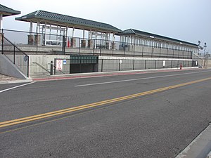
Lehi station
Commuter rail station in Lehi, Utah, US
Distance: Approx. 9172 meters
Latitude and longitude: 40.42527778,-111.89638889
Lehi station, also known as Thanksgiving Point station, is a FrontRunner commuter rail station in Lehi, Utah. It is operated by the Utah Transit Authority (UTA) and is part of the FrontRunner South extension.

Saratoga Springs Utah Temple
Distance: Approx. 6493 meters
Latitude and longitude: 40.3442,-111.9327
The Saratoga Springs Utah Temple is a temple of the Church of Jesus Christ of Latter-day Saints in Saratoga Springs, Utah.

Cedar Valley High School
Public secondary school in Eagle Mountain, Utah, United States
Distance: Approx. 7294 meters
Latitude and longitude: 40.3214,-112.01771
Cedar Valley High School is a public high school in Eagle Mountain, Utah, United States. It serves students in grades 9-12 for the Alpine School District.
Weather in this IP's area
light rain
5 Celsius
-0 Celsius
3 Celsius
6 Celsius
1015 hPa
80 %
1015 hPa
844 hPa
10000 meters
7.6 m/s
11.62 m/s
2 degree
100 %
07:42:27
18:43:12