Country:
 USA
USARegion:
City:
Latitude and Longitude:
Time Zone:
Postal Code:
IP information under different IP Channel
ip-api
Country
Region
City
ASN
Time Zone
ISP
Blacklist
Proxy
Latitude
Longitude
Postal
Route
IPinfo
Country
Region
City
ASN
Time Zone
ISP
Blacklist
Proxy
Latitude
Longitude
Postal
Route
MaxMind
Country
Region
City
ASN
Time Zone
ISP
Blacklist
Proxy
Latitude
Longitude
Postal
Route
Luminati
Country
USRegion
wa
City
kennewick
ASN
Time Zone
America/Los_Angeles
ISP
NOANET-WA
Latitude
Longitude
Postal
db-ip
Country
Region
City
ASN
Time Zone
ISP
Blacklist
Proxy
Latitude
Longitude
Postal
Route
ipdata
Country
Region
City
ASN
Time Zone
ISP
Blacklist
Proxy
Latitude
Longitude
Postal
Route
Popular places and events near this IP address
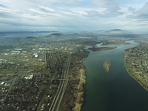
Tri-Cities, Washington
Place in Washington, United States
Distance: Approx. 2741 meters
Latitude and longitude: 46.22361111,-119.13583333
The Tri-Cities are three closely linked cities (Kennewick, Pasco, and Richland) at the confluence of the Yakima, Snake, and Columbia Rivers in the Columbia Basin of Eastern Washington. The cities border one another, making the Tri-Cities seem like one uninterrupted mid-sized city. The three cities function as the center of the Tri-Cities metropolitan area, which consists of Benton and Franklin counties.
Kennewick, Washington
City in the United States
Distance: Approx. 2979 meters
Latitude and longitude: 46.20361111,-119.15916667
Kennewick () is a city in Benton County in the U.S. state of Washington. It is located along the southwest bank of the Columbia River, just southeast of the confluence of the Columbia and Yakima rivers and across from the confluence of the Columbia and Snake rivers. It is the most populous of the three cities collectively referred to as the Tri-Cities (the others being Pasco and Richland).

Kennewick Man
Ancient skeleton of Indigenous American man
Distance: Approx. 2201 meters
Latitude and longitude: 46.22305556,-119.14333333
Kennewick Man or Ancient One was a Native American man who lived during the early Holocene, whose skeletal remains were found washed out on a bank of the Columbia River in Kennewick, Washington, on July 28, 1996. Radiocarbon tests show the man lived about 8,400 to 8,690 years Before Present, making his skeleton one of the most complete ever found this old in the Americas, and thus of high scientific interest for understanding the peopling of the Americas. The discovery precipitated a nearly twenty-year-long dispute.

West Pasco, Washington
Census-designated place in Washington, United States
Distance: Approx. 2761 meters
Latitude and longitude: 46.2525,-119.18277778
West Pasco is a census-designated place (CDP) in Franklin County, Washington, United States. The population was 1,747 at the 2020 census, a significant decrease from 3,739 at the 2010 census. Based on per capita income, one of the more reliable measures of affluence, West Pasco ranks 47th of 522 areas in the state of Washington to be ranked.

Kamiakin High School
Public, four-year school in Kennewick, Washington, United States
Distance: Approx. 1898 meters
Latitude and longitude: 46.2172,-119.188
Kamiakin High School is a public high school in Kennewick, Washington, the second of three comprehensive high schools in the Kennewick School District. Kamiakin opened in the fall of 1970 and serves the district's northwest portion. The school colors are scarlet and gold and the mascot is the Braves.
Blue Bridge (Washington)
Four-lane arch-truss bridge
Distance: Approx. 2721 meters
Latitude and longitude: 46.22497778,-119.1357
The Blue Bridge (officially named the Pioneer Memorial Bridge) is a four-lane arch-truss bridge connecting Pasco, Washington to Kennewick, Washington. U.S. Route 395 crosses the Columbia River via this bridge. The name comes from the blue paint used on the truss superstructure, with white paint on the suspension beams.
Vista Field
Airport in Washington, U.S.
Distance: Approx. 3210 meters
Latitude and longitude: 46.22,-119.21
Vista Field (IATA: VSK, FAA LID: S98) was a public use airport in Benton County, Washington, United States. The airport was located three nautical miles (6 km) northwest of the central business district of Kennewick and was owned by the Port of Kennewick. It was also known as Vista Field Airport.
KFLD
Radio station in Pasco, Washington
Distance: Approx. 3463 meters
Latitude and longitude: 46.22805556,-119.12555556
KFLD (870 AM) is a radio station broadcasting a news/talk format. Licensed to Pasco, Washington, United States, the station serves the Tri-Cities area. The station is currently owned by Townsquare Media and features programming from Fox News Radio, Compass Media Networks, Salem Radio Network, and Westwood One.
KALE
Radio station in Richland, Washington
Distance: Approx. 1620 meters
Latitude and longitude: 46.24277778,-119.17805556
KALE (960 AM, "106.1 The Bridge") is a radio station licensed to Richland, Washington, United States, the station serves the Tri-Cities, Washington area. The station is owned by Stephens Media Group.
KJOX (AM)
Radio station in Kennewick, Washington
Distance: Approx. 1466 meters
Latitude and longitude: 46.22166667,-119.18611111
KJOX (1340 AM) is a radio station broadcasting a sports format. Located in Kennewick, Washington, United States, the station serves the Tri-Cities, Washington area. The station is owned by Stephens Media Group and features programming from ESPN Radio, ESPN Seattle, and Westwood One.

Columbia Park (Tri-Cities)
Public park in Washington, US
Distance: Approx. 2235 meters
Latitude and longitude: 46.22034722,-119.14445278
Columbia Park is a public park located in Benton County, Washington, United States. The park comprises the 400-acre (160 ha) Columbia Park East in Kennewick, and the adjacent 50-acre (20 ha) Columbia Park West in Richland. Together, the parks function as a single 450-acre (180 ha) park with 4.5 miles (7.2 km) of shoreline along the Columbia River.
Mid-Columbia Libraries
Distance: Approx. 2979 meters
Latitude and longitude: 46.20361111,-119.15916667
Mid-Columbia Libraries is a library system in Eastern Washington. There were 250,500 people in its service area in 2018, which spans the Tri-Cities metropolitan area except for Richland, which retains a city library: West Richland, Kennewick, and Pasco, and surrounding Benton, Franklin, and parts of Adams Counties are part of Mid-Columbia. It was founded in 1948, originally to serve patrons in unincorporated parts of the counties.
Weather in this IP's area
clear sky
14 Celsius
13 Celsius
12 Celsius
15 Celsius
1018 hPa
59 %
1018 hPa
1005 hPa
10000 meters
5.14 m/s
240 degree
07:22:44
17:59:21