Country:
 USA
USARegion:
City:
Latitude and Longitude:
Time Zone:
Postal Code:
IP information under different IP Channel
ip-api
Country
Region
City
ASN
Time Zone
ISP
Blacklist
Proxy
Latitude
Longitude
Postal
Route
IPinfo
Country
Region
City
ASN
Time Zone
ISP
Blacklist
Proxy
Latitude
Longitude
Postal
Route
MaxMind
Country
Region
City
ASN
Time Zone
ISP
Blacklist
Proxy
Latitude
Longitude
Postal
Route
Luminati
Country
USASN
Time Zone
America/Chicago
ISP
BBO-1
Latitude
Longitude
Postal
db-ip
Country
Region
City
ASN
Time Zone
ISP
Blacklist
Proxy
Latitude
Longitude
Postal
Route
ipdata
Country
Region
City
ASN
Time Zone
ISP
Blacklist
Proxy
Latitude
Longitude
Postal
Route
Popular places and events near this IP address

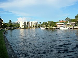
Deerfield Beach, Florida
City in Florida, United States
Distance: Approx. 1049 meters
Latitude and longitude: 26.31805556,-80.09972222
Deerfield Beach is a city in Broward County, Florida, United States, just south of the Palm Beach County line. As of the 2020 census, the population was 86,859, making it the tenth-largest city in Broward County. Located 41 miles north of Miami, it is a key suburb of the Miami metropolitan area, which was home to 6.14 million people in 2020.

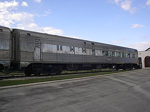
Deerfield Beach station
Railway station in Florida, United States
Distance: Approx. 1217 meters
Latitude and longitude: 26.31694444,-80.12222222
Deerfield Beach station, also known as the Old Deerfield Beach Seaboard Air Line Railway Station, is a train station in Deerfield Beach, Florida. It is served by Amtrak intercity rail and Tri-Rail commuter rail trains. Located at 1300 West Hillsboro Boulevard (SR 810), just east of North Military Trail (SR 809), the station was built in 1926 by the Seaboard Air Line Railway.
Deerfield Beach High School
Public, magnet school in Deerfield Beach, Florida, United States
Distance: Approx. 2703 meters
Latitude and longitude: 26.2953576,-80.1172663
Deerfield Beach High School (DBHS) is a public high school in Deerfield Beach, Florida. It is part of the Broward School District and has an enrollment of approximately 2,400. The school features the IB Middle Years Programme or Pre-IB, which is a prerequisite for the International Baccalaureate program that offers college-level academics to students in 11th and 12th grade.

Deerfield Beach Arboretum
Distance: Approx. 3115 meters
Latitude and longitude: 26.318831,-80.141417
The Deerfield Beach Arboretum, also known as the Tree Zoo, is an arboretum and botanical garden located in Deerfield Beach, Florida, United States. It covers 9 acres (3.6 ha). It is owned by the city of Deerfield Beach and managed by The Friends of the Deerfield Beach Arboretum.
Hillsboro Canal
Canal in Florida, United States
Distance: Approx. 1046 meters
Latitude and longitude: 26.327869,-80.107451
The Hillsboro Canal is located in the southeastern portion of Florida within the South Florida Water Management District, and for much of its length forms the border between Broward and Palm Beach counties; however, its western end was entirely in Palm Beach County, until being recently annexed to Broward County-Parkland, FL . It begins at Lake Okeechobee at the S-2 water control structure in South Bay west of Belle Glade, Florida. It passes within the southern border of the Loxahatchee National Wildlife Refuge and flows southeast from there along Loxahatchee Road in a rural, lightly populated area.
Seaboard Air Line 6113
Distance: Approx. 3369 meters
Latitude and longitude: 26.34241,-80.089079
The Seaboard Air Line Dining Car-#6113 is a historic Seaboard Air Line Railroad dining car in Boca Raton, Florida. It has been restored, and is located at 747 South Dixie Highway, off U.S. 1, part of the Boca Express Train Museum. On April 5, 2001, it was added to the U.S. National Register of Historic Places.

Seaboard Air Line 6603
United States historic place
Distance: Approx. 3346 meters
Latitude and longitude: 26.342179,-80.08912
The Seaboard Air Line Lounge Car-6603 is a historic Seaboard Air Line Railroad passenger car in Boca Raton, Florida. It is located at 747 South Dixie Highway, off U.S. 1, part of the restored Florida East Coast Railway Passenger Station. On April 5, 2001, it was added to the U.S. National Register of Historic Places.

James D. and Alice Butler House
Historic house in Florida, United States
Distance: Approx. 1222 meters
Latitude and longitude: 26.31804722,-80.09798333
The James D. and Alice Butler House, commonly known as the Butler House, is a historic house museum in Deerfield Beach, Florida. It is located at 380 East Hillsboro Boulevard. On July 28, 1995, it was added to the U.S. National Register of Historic Places.

Old Deerfield School
School in Deerfield Beach, Florida, United States
Distance: Approx. 1100 meters
Latitude and longitude: 26.3203,-80.0993
Old Deerfield School is a historic school in Deerfield Beach, Florida, United States. It is located at 232 North East 2nd Street. Designed by A.E. Lewis it was built by Edgar S. Tubbs in 1920.

Deerfield Beach Elementary School
Public, elementary school in Deerfield Beach, Florida, United States
Distance: Approx. 1491 meters
Latitude and longitude: 26.3198,-80.0953
The Deerfield Beach Elementary School is a historic school in Deerfield Beach, Florida. It is located at 651 Northeast 1st Street and is in the Broward County Public Schools school district. On April 16, 1990, it was added to the United States National Register of Historic Places.

Administration Buildings (Boca Raton, Florida)
United States historic place
Distance: Approx. 3197 meters
Latitude and longitude: 26.34031667,-80.088975
The Administration Buildings are a historic site in Boca Raton, Florida, United States. They are located at 2 East Camino Real. On June 27, 1985, they were added to the U.S. National Register of Historic Places.
South Florida Bible College & Theological Seminary
Christian Bible college in Florida, United States
Distance: Approx. 2987 meters
Latitude and longitude: 26.30305556,-80.13444444
South Florida Bible College & Theological Seminary (SFBC or SFBC&TS) is a private Christian bible college and seminary in Deerfield Beach, Florida. It offers undergraduate degrees and graduate degrees.
Weather in this IP's area
heavy intensity rain
26 Celsius
26 Celsius
26 Celsius
28 Celsius
1012 hPa
94 %
1012 hPa
1011 hPa
4828 meters
6.69 m/s
9.26 m/s
240 degree
100 %
07:03:35
19:32:40