Country:
 USA
USARegion:
City:
Latitude and Longitude:
Time Zone:
Postal Code:
IP information under different IP Channel
ip-api
Country
Region
City
ASN
Time Zone
ISP
Blacklist
Proxy
Latitude
Longitude
Postal
Route
IPinfo
Country
Region
City
ASN
Time Zone
ISP
Blacklist
Proxy
Latitude
Longitude
Postal
Route
MaxMind
Country
Region
City
ASN
Time Zone
ISP
Blacklist
Proxy
Latitude
Longitude
Postal
Route
Luminati
Country
USRegion
mi
City
kalamazoo
ASN
Time Zone
America/Detroit
ISP
CTSTELECOM
Latitude
Longitude
Postal
db-ip
Country
Region
City
ASN
Time Zone
ISP
Blacklist
Proxy
Latitude
Longitude
Postal
Route
ipdata
Country
Region
City
ASN
Time Zone
ISP
Blacklist
Proxy
Latitude
Longitude
Postal
Route
Popular places and events near this IP address

Kalamazoo Township, Michigan
Charter township in Michigan, United States
Distance: Approx. 930 meters
Latitude and longitude: 42.31111111,-85.58805556
Kalamazoo Charter Township is a charter township of Kalamazoo County in the U.S. state of Michigan. The population was 22,777 at the 2020 census. The cities of Kalamazoo and Parchment are adjacent to the township and have annexed much land that was formerly within the township, such that the township now consists of two non-contiguous sections of land and one small section that is connected by a narrow point across Riverview Drive.

Heritage Guitars
Distance: Approx. 911 meters
Latitude and longitude: 42.3017302,-85.5808211
Heritage Guitar is an American musical instrument manufacturer company based in Kalamazoo, Michigan, United States. The company produces a range of electric guitars, including hollow-body models.

Kalamazoo Transportation Center
Distance: Approx. 1053 meters
Latitude and longitude: 42.29555556,-85.58416667
The Kalamazoo Transportation Center is an intermodal complex in downtown Kalamazoo, Michigan. Both Amtrak and Greyhound provide regular service, and the center is also the major downtown transfer hub for Kalamazoo's Metro Transit bus system. It is the second-busiest Amtrak station in Michigan.
Northglade Montessori Magnet School
Magnet school in Kalamazoo, Michigan, United States
Distance: Approx. 778 meters
Latitude and longitude: 42.31,-85.59388889
Northglade Montessori Magnet School is a public elementary magnet school for students grades K-5, operated by the Kalamazoo Public Schools, located in Kalamazoo, Michigan, United States. It was established in August 2001 by the restructuring of Northglade Elementary School. The school serves around 250 children, of whom 83% are black and 13% white.

Masonic Temple Building (Kalamazoo, Michigan)
United States historic place
Distance: Approx. 1174 meters
Latitude and longitude: 42.29388889,-85.585
The Masonic Temple in Kalamazoo, Michigan, is a building from 1913. It was listed on the National Register of Historic Places in 1980. No lodges currently meet in the building.

Old Fire House No. 4 (Kalamazoo, Michigan)
United States historic place
Distance: Approx. 974 meters
Latitude and longitude: 42.29722222,-85.58305556
Old Fire House No. 4 is a former fire station located at 526 North Burdick Street in Kalamazoo, Michigan. It was listed on the National Register of Historic Places in 1983.

Charles E. Stuart House
United States historic place
Distance: Approx. 1025 meters
Latitude and longitude: 42.29527778,-85.59805556
The Charles E. Stuart House is a single-family home located at 427 Stuart Avenue in Kalamazoo, Michigan. It was listed on the National Register of Historic Places in 1972.

Enoch Shaffer House
United States historic place
Distance: Approx. 1011 meters
Latitude and longitude: 42.30611111,-85.60333333
The Enoch Shaffer House is a single-family home located at 1437 Douglas Avenue in Kalamazoo, Michigan. It is one of only a few Late Victorian farmhouses in Kalamazoo, and is notable for its fine detailing. It was listed on the National Register of Historic Places in 1983.

Stuart Area Historic District
United States historic place
Distance: Approx. 1117 meters
Latitude and longitude: 42.29444444,-85.59833333
The Stuart Area Historic District is a primarily residential historic district in Kalamazoo, Michigan, roughly bounded by the Michigan Central Railroad, Douglas, Forbes, West Main, North, and Elm Streets, and Kalamazoo and Grand Avenues. The bulk of the district was listed on the National Register of Historic Places in 1983, with additions in 1995.

Rickman House
United States historic place
Distance: Approx. 1206 meters
Latitude and longitude: 42.29416667,-85.58361111
The Rickman House is an apartment building located at 345 North Burdick in Kalamazoo, Michigan. It was formerly a hotel known as the Rickman Hotel. It was listed on the National Register of Historic Places in 1994.
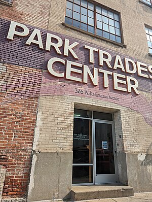
Park Trades Center
Distance: Approx. 1023 meters
Latitude and longitude: 42.29488333,-85.58640556
The Park Trades Center is an arts center located at 326 W. Kalamazoo Ave in Kalamazoo, Michigan, United States. Originally a manufacturing faculty, the building was repurposed and began to attract artists in the 1970s, and now houses artist studios and arts organizations. Occupants have included Glass Arts Kalamazoo and the Kalamazoo Book Arts Center, as well as studios dedicated to blacksmithing, cabinetmaking, glassblowing, ceramics, photography and other mediums.
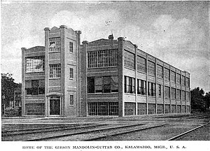
Gibson, Inc. Factory and Office Building
United States historic place
Distance: Approx. 924 meters
Latitude and longitude: 42.30111111,-85.58083333
The Gibson, Inc. Factory and Office Building is a former industrial building located at 225 Parsons Street in Kalamazoo, Michigan. It was listed on the National Register of Historic Places in 2022.
Weather in this IP's area
few clouds
30 Celsius
29 Celsius
28 Celsius
31 Celsius
1019 hPa
31 %
1019 hPa
992 hPa
10000 meters
3.64 m/s
3.65 m/s
83 degree
16 %
07:23:57
19:50:19