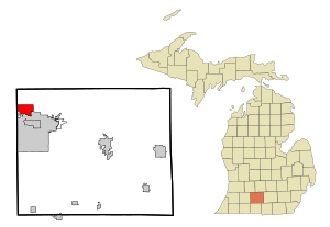
Country:
 USA
USARegion:
City:
Latitude and Longitude:
Time Zone:
Postal Code:
IP information under different IP Channel
ip-api
Country
Region
City
ASN
Time Zone
ISP
Blacklist
Proxy
Latitude
Longitude
Postal
Route
IPinfo
Country
Region
City
ASN
Time Zone
ISP
Blacklist
Proxy
Latitude
Longitude
Postal
Route
MaxMind
Country
Region
City
ASN
Time Zone
ISP
Blacklist
Proxy
Latitude
Longitude
Postal
Route
Luminati
Country
USRegion
mi
City
battlecreek
ASN
Time Zone
America/Detroit
ISP
CTSTELECOM
Latitude
Longitude
Postal
db-ip
Country
Region
City
ASN
Time Zone
ISP
Blacklist
Proxy
Latitude
Longitude
Postal
Route
ipdata
Country
Region
City
ASN
Time Zone
ISP
Blacklist
Proxy
Latitude
Longitude
Postal
Route
Popular places and events near this IP address

Bedford Charter Township, Michigan
Charter township in Michigan, United States
Distance: Approx. 3376 meters
Latitude and longitude: 42.37305556,-85.23833333
Bedford Charter Township is a charter township located in the northwest corner of Calhoun County in the U.S. state of Michigan. It is part of the Battle Creek, Michigan Metropolitan Statistical Area. As of the 2020 census, the township population was 9,198.
Level Park–Oak Park, Michigan
Census-designated place & unincorporated community in Michigan, United States
Distance: Approx. 3611 meters
Latitude and longitude: 42.36055556,-85.25805556
Level Park–Oak Park is a census-designated place for statistical purposes in Calhoun County in the U.S. state of Michigan. The CDP population was 3,260 at the 2020 census. The CDP is immediately northwest of the city of Battle Creek and is part of the Battle Creek Metropolitan Statistical Area.

Springfield, Michigan
City in Michigan, United States
Distance: Approx. 2743 meters
Latitude and longitude: 42.32361111,-85.23083333
There are also two Springfield Townships in Michigan. Springfield is a city in Calhoun County, Michigan, United States. It is an enclave of the city of Battle Creek.

Battle Creek River
River in the United States of America
Distance: Approx. 3349 meters
Latitude and longitude: 42.32254,-85.193881
The Battle Creek River (simply Battle Creek on federal maps) is a river in the U.S. state of Michigan. It is a tributary of the Kalamazoo River, joining it at Battle Creek, Michigan; the Kalamazoo River empties into Lake Michigan. The river's drainage basin is approximately 196,750 acres (796.2 km2) and covers northern Calhoun County, southern Eaton County, and southeastern Barry County in southwest Michigan.

Leila Arboretum
Arboretum and garden
Distance: Approx. 933 meters
Latitude and longitude: 42.33895,-85.21359
The Leila Arboretum is an arboretum and garden located at 928 West Michigan Avenue, Battle Creek, Michigan. The arboretum is 72 acres, and is open to the public. The Arboretum's collections include nearly 1,700 accessioned woody plants and about 25,000 total plants, comprising trees, shrubs, and perennial and annual plantings laid out in the manner of European gardens.

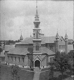
Battle Creek Sanitarium
United States historic place
Distance: Approx. 3336 meters
Latitude and longitude: 42.32694444,-85.18777778
The Battle Creek Sanitarium was a world-renowned health resort in Battle Creek, Michigan, United States. It started in 1866 on health principles advocated by the Seventh-day Adventist Church and from 1876 to 1943 was managed by Dr. John Harvey Kellogg.
Robert B. Miller College
Distance: Approx. 3581 meters
Latitude and longitude: 42.333,-85.179
The Robert B. Miller College was a private college in Battle Creek, Michigan. It was housed in the Mawby Center of Kellogg Community College and closed in 2016.
Dime Tabernacle
Distance: Approx. 3325 meters
Latitude and longitude: 42.32483333,-85.19069444
The Dime Tabernacle was the fourth Seventh-day Adventist church to be built in Battle Creek, Michigan. It was dedicated on April 20, 1879, and could accommodate 4000 worshipers as Battle Creek had become the center of the Seventh Day Adventist leadership, and the work of the church after it formed. The unusual name comes from the way money was raised to build the church.

Hart–Dole–Inouye Federal Center
United States historic place
Distance: Approx. 3336 meters
Latitude and longitude: 42.32694444,-85.18777778
The Hart–Dole–Inouye Federal Center, formerly the Battle Creek Federal Center, is a complex of federal buildings located in Battle Creek, Michigan.

Advent Historic District
United States historic place
Distance: Approx. 2650 meters
Latitude and longitude: 42.33,-85.19527778
The Advent Historic District is a residential historic district, roughly bounded by North Washington Avenue, Champion Street, Hubbard Street, and Greenwood Avenue, in Battle Creek, Michigan. The district encompasses the heart of the former village of Washington Heights, which was developed as a by-product of the growth of the Seventh-day Adventist Church in the area during the last half of the nineteenth and the early part of the twentieth. The area was annexed into Battle Creek in 1926.

Roosevelt American Legion Hospital
Demolished hospital
Distance: Approx. 3564 meters
Latitude and longitude: 42.33972222,-85.26083333
The Roosevelt American Legion Hospital, also known as the 'Roosevelt Community House, the Legion Villa, or The Rotunda, was a health care facility located at 107 Evergreen Road in Springfield, Michigan. It was listed on the National Register of Historic Places in 2001. The building was demolished in 2016, and was removed from the National Register in 2020.

Phelps Sanitarium
Demolished hospital
Distance: Approx. 3424 meters
Latitude and longitude: 42.32694444,-85.18638889
The Phelps Sanitarium, later known as the Battle Creek Sanitarium, was a health care facility located at 197 N. Washington Avenue in Battle Creek, Michigan. The building was demolished in 1985.
Weather in this IP's area
clear sky
30 Celsius
28 Celsius
28 Celsius
31 Celsius
1019 hPa
26 %
1019 hPa
991 hPa
10000 meters
4.12 m/s
100 degree
07:22:26
19:48:51