Country:
 USA
USARegion:
City:
Latitude and Longitude:
Time Zone:
Postal Code:
IP information under different IP Channel
ip-api
Country
Region
City
ASN
Time Zone
ISP
Blacklist
Proxy
Latitude
Longitude
Postal
Route
IPinfo
Country
Region
City
ASN
Time Zone
ISP
Blacklist
Proxy
Latitude
Longitude
Postal
Route
MaxMind
Country
Region
City
ASN
Time Zone
ISP
Blacklist
Proxy
Latitude
Longitude
Postal
Route
Luminati
Country
USRegion
mi
City
battlecreek
ASN
Time Zone
America/Detroit
ISP
CTSTELECOM
Latitude
Longitude
Postal
db-ip
Country
Region
City
ASN
Time Zone
ISP
Blacklist
Proxy
Latitude
Longitude
Postal
Route
ipdata
Country
Region
City
ASN
Time Zone
ISP
Blacklist
Proxy
Latitude
Longitude
Postal
Route
Popular places and events near this IP address
Kellogg Arena
Arena in Battle Creek, Michigan, USA
Distance: Approx. 863 meters
Latitude and longitude: 42.319098,-85.185478
Kellogg Arena is a 6,200-seat multi-purpose arena located in Battle Creek, Michigan.
St. Philip Catholic Central High School
Private, coeducational school in Battle Creek, Michigan, United States
Distance: Approx. 428 meters
Latitude and longitude: 42.32083333,-85.17861111
St. Philip Catholic Central High School, located in the Roman Catholic Diocese of Kalamazoo, is a Roman Catholic high school in Battle Creek, Michigan.
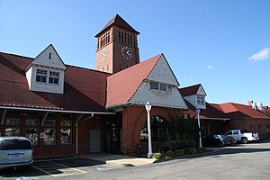
Battle Creek station (Michigan Central Railroad)
Station in Battle Creek, Michigan
Distance: Approx. 623 meters
Latitude and longitude: 42.32111111,-85.18138889
Battle Creek station, listed in the National Register of Historic Places as the Penn Central Railway Station, is a disused train station in Battle Creek, Michigan. It opened on July 27, 1888. Rogers and MacFarlane of Detroit designed the depot, one of several Richardsonian Romanesque-style stations between Detroit and Chicago in the late nineteenth century.

Old Battle Creek Post Office
United States historic place
Distance: Approx. 413 meters
Latitude and longitude: 42.31722222,-85.18
The Old Battle Creek Post Office is a former post office located at 67 East Michigan Avenue in Battle Creek, Michigan. It was listed on the National Register of Historic Places in 1972.

Adam C. Arnold Block
United States historic place
Distance: Approx. 556 meters
Latitude and longitude: 42.31916667,-85.18166667
The Adam C. Arnold Block was a commercial building located at 12-14 East State Street in Battle Creek, Michigan. It was listed on the National Register of Historic Places in 1983. It was demolished in 1988.

Battle Creek City Hall
United States historic place
Distance: Approx. 387 meters
Latitude and longitude: 42.31666667,-85.17944444
The Battle Creek City Hall is a governmental building located at 103 East Michigan Avenue in Battle Creek, Michigan. It was listed on the National Register of Historic Places in 1984.
City Hall Historic District (Battle Creek, Michigan)
United States historic place
Distance: Approx. 398 meters
Latitude and longitude: 42.31694444,-85.17972222
The City Hall Historic District is a commercial and municipal historic district located along East Michigan Avenue from Monroe to Jay Streets in Battle Creek, Michigan. It was listed on the National Register of Historic Places in 1996.

W. K. Kellogg House
United States historic place
Distance: Approx. 413 meters
Latitude and longitude: 42.31944444,-85.17972222
The W.K. Kellogg House, located at 1 Monroe Street in Battle Creek, Michigan, was built as a private house for Kellogg Company founder Will Keith Kellogg. It was listed on the National Register of Historic Places in 1985. In 1990, it was moved from its original location at 256 West Van Buren Street to its present location near the W.K. Kellogg Foundation headquarters.

Van Buren Street Historic District
United States historic place
Distance: Approx. 711 meters
Latitude and longitude: 42.32277778,-85.18083333
The Van Buren Street Historic District is a cultural historic district located roughly along Van Buren Street from Capital and Cherry Streets to Calhoun Street and North Avenue in Battle Creek, Michigan. It was listed on the National Register of Historic Places in 1996.

Maple Street Historic District (Battle Creek, Michigan)
United States historic place
Distance: Approx. 558 meters
Latitude and longitude: 42.32277778,-85.17305556
The Maple Street Historic District is a residential historic district located at 161-342 Capital Avenue NE in Battle Creek, Michigan. It was listed on the National Register of Historic Places in 1996.

Battle Creek Tower
United States historic place
Distance: Approx. 836 meters
Latitude and longitude: 42.32138889,-85.18416667
The Battle Creek Tower is a mixed-use commercial and residential building located at 70 West Michigan Avenue in Battle Creek, Michigan. It was originally built as the Central National Tower, and designed as an office building. It was listed on the National Register of Historic Places in 2008.

Heritage Tower (Battle Creek, Michigan)
Building in Battle Creek
Distance: Approx. 692 meters
Latitude and longitude: 42.32,-85.18305556
The Heritage Tower is a mixed-use commercial and residential building located at 25 West Michigan Avenue in Battle Creek, Michigan. It was originally built as the Old-Merchants National Bank and Trust Company Building, and designed as an office building. It was listed on the National Register of Historic Places in 2018.
Weather in this IP's area
clear sky
18 Celsius
17 Celsius
17 Celsius
19 Celsius
1030 hPa
31 %
1030 hPa
1001 hPa
10000 meters
2.06 m/s
190 degree
07:57:23
18:53:47