Country:
 USA
USARegion:
City:
Latitude and Longitude:
Time Zone:
Postal Code:
IP information under different IP Channel
ip-api
Country
Region
City
ASN
Time Zone
ISP
Blacklist
Proxy
Latitude
Longitude
Postal
Route
IPinfo
Country
Region
City
ASN
Time Zone
ISP
Blacklist
Proxy
Latitude
Longitude
Postal
Route
MaxMind
Country
Region
City
ASN
Time Zone
ISP
Blacklist
Proxy
Latitude
Longitude
Postal
Route
Luminati
Country
USASN
Time Zone
America/Chicago
ISP
INTERNAP-BLOCK-4
Latitude
Longitude
Postal
db-ip
Country
Region
City
ASN
Time Zone
ISP
Blacklist
Proxy
Latitude
Longitude
Postal
Route
ipdata
Country
Region
City
ASN
Time Zone
ISP
Blacklist
Proxy
Latitude
Longitude
Postal
Route
Popular places and events near this IP address

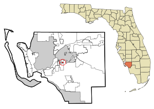
Fort Myers, Florida
City in Florida, United States
Distance: Approx. 2592 meters
Latitude and longitude: 26.61666667,-81.83333333
Fort Myers (or Ft. Myers) is a city in and the county seat of Lee County, Florida, United States. As of the 2020 census, the population was 86,395; it was estimated to have grown to 95,949 in 2022, making it the 25th-most populous city in Florida.
Page Park, Florida
Census-designated place in Florida, United States
Distance: Approx. 2617 meters
Latitude and longitude: 26.57805556,-81.86111111
Page Park is a census-designated place (CDP) in Lee County, Florida, United States. The population was 747 at the 2020 census, up from 514 at the 2010 census. It is part of the Cape Coral-Fort Myers, Florida Metropolitan Statistical Area.

Page Field
Airport in Florida, U.S.
Distance: Approx. 1892 meters
Latitude and longitude: 26.58666667,-81.86333333
Page Field (IATA: FMY, ICAO: KFMY, FAA LID: FMY) is a public airport located in Fort Myers, in Lee County, Florida, United States. It is owned by the Lee County Port Authority; the National Plan of Integrated Airport Systems for 2011–2015 categorized it as a reliever airport.

Battle of Fort Myers
American Civil War battle in Florida
Distance: Approx. 3583 meters
Latitude and longitude: 26.631667,-81.857222
The Battle of Fort Myers was fought on February 20, 1865, in Lee County, Florida during the last months of the American Civil War.

Bishop Verot High School
Private, coeducational school in Fort Myers, Florida
Distance: Approx. 3625 meters
Latitude and longitude: 26.58861111,-81.88555556
Bishop Verot High School is a private, Roman Catholic high school in Fort Myers, Florida. It is located in the Diocese of Venice, Florida.

WZKO
Radio station in Fort Myers, Florida
Distance: Approx. 2996 meters
Latitude and longitude: 26.62527778,-81.84138889
WZKO (1350 AM) is a radio station licensed to Fort Myers, Florida, United States. It airs an urban adult contemporary format branded as "107.5 Jamz".
Evangelical Christian School (Fort Myers, Florida)
School in Fort Myers, Florida, United States
Distance: Approx. 2994 meters
Latitude and longitude: 26.57444444,-81.86111111
Evangelical Christian School (ECS) is a private, college preparatory, non-denominational Christian school in Fort Myers, Florida.
Southwest Florida Regional Medical Center
Hospital in Florida, United States
Distance: Approx. 939 meters
Latitude and longitude: 26.606373,-81.857445
Southwest Florida Regional Medical Center was a 400-bed general hospital in Fort Myers, Florida. Then Ft Myers Community Hospital was originally developed by a subsidiary of Basic American Industries (BAI) called Basic American Medical in 1974. BAI was based in Indianapolis, Indiana.

Edison Mall
Shopping mall in Florida, United States
Distance: Approx. 1763 meters
Latitude and longitude: 26.601881,-81.868972
Edison Mall is an enclosed, super-regional shopping mall in Fort Myers, Florida. The mall opened in 1965, and has been expanded three times since. Edison Mall is owned by Washington Prime Group, which took over the mall in 2014.

Page Field Army Airfield
Former United States Army Air Forces base
Distance: Approx. 1892 meters
Latitude and longitude: 26.58666667,-81.86333333
Page Field Army Airfield' was a United States Army Air Forces base, approximately 4 miles south of Fort Myers, Florida. It was active during World War II as a Third Air Force training airfield. It was closed on 30 September 1945, two years prior to the establishment of the United States Air Force as an independent service.
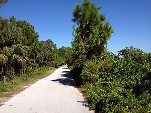
John Yarbrough Linear Park
Linear park trail in Fort Myers, Florida, U.S.
Distance: Approx. 3466 meters
Latitude and longitude: 26.56897,-81.85539
The John Yarbrough Linear Park (originally the Ten Mile Canal Linear Park) is a 6-mile linear park trail located in Fort Myers, Florida. The trail parallels the Ten Mile Canal and the Seminole Gulf Railway, and is owned and operated by Lee County Parks and Recreation. It is part of Lee County's Tour de Parks route along with Lakes Regional Park and other locations.
Southwest Florida College
Private Career Training College
Distance: Approx. 2642 meters
Latitude and longitude: 26.5967,-81.8777
Southwest Florida College (SWFC) was a private career training college in Florida. It has campuses in Fort Myers, Tampa and Port Charlotte, as well as a "learning site" in Bonita Springs. In 2014, Southern Technical College Suncoast LLC, acquired these campuses and changed the name to Southern Technical College.
Weather in this IP's area
very heavy rain
24 Celsius
25 Celsius
24 Celsius
26 Celsius
1003 hPa
95 %
1003 hPa
1003 hPa
10000 meters
5.66 m/s
60 degree
100 %
07:22:46
19:07:07