Country:
 USA
USARegion:
City:
Latitude and Longitude:
Time Zone:
Postal Code:
IP information under different IP Channel
ip-api
Country
Region
City
ASN
Time Zone
ISP
Blacklist
Proxy
Latitude
Longitude
Postal
Route
IPinfo
Country
Region
City
ASN
Time Zone
ISP
Blacklist
Proxy
Latitude
Longitude
Postal
Route
MaxMind
Country
Region
City
ASN
Time Zone
ISP
Blacklist
Proxy
Latitude
Longitude
Postal
Route
Luminati
Country
USASN
Time Zone
America/Chicago
ISP
INTERNAP-2BLK
Latitude
Longitude
Postal
db-ip
Country
Region
City
ASN
Time Zone
ISP
Blacklist
Proxy
Latitude
Longitude
Postal
Route
ipdata
Country
Region
City
ASN
Time Zone
ISP
Blacklist
Proxy
Latitude
Longitude
Postal
Route
Popular places and events near this IP address
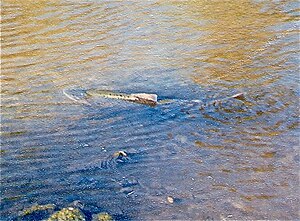
Guadalupe River (California)
River in Santa Clara County, California, United States
Distance: Approx. 1247 meters
Latitude and longitude: 37.42583333,-121.97944444
The Guadalupe River (Spanish: Río Guadalupe; Muwekma Ohlone:Thámien Rúmmey) mainstem is an urban, northward flowing 14 miles (23 km) river in California whose much longer headwater creeks originate in the Santa Cruz Mountains. The river mainstem now begins on the Santa Clara Valley floor when Los Alamitos Creek exits Lake Almaden and joins Guadalupe Creek just downstream of Coleman Road in San Jose, California. From here it flows north through San Jose, where it receives Los Gatos Creek, a major tributary.

Lick Mill station
VTA light rail station in Santa Clara, California
Distance: Approx. 1444 meters
Latitude and longitude: 37.407699,-121.963338
Lick Mill station is a light rail station operated by Santa Clara Valley Transportation Authority (VTA). Lick Mill is served by the Orange and Green light rail lines. Lick Mill is VTA's recommended transfer point for Altamont Corridor Express (ACE) commuter rail and Capitol Corridor inter-city rail trains at Santa Clara – Great America station.

Great America station
VTA light rail station in Santa Clara, California
Distance: Approx. 1276 meters
Latitude and longitude: 37.403523,-121.974442
Great America station (officially Great America/Levi's Stadium station) is a light rail station operated by Santa Clara Valley Transportation Authority (VTA). Great America is served by the Orange and Green light rail lines. Great America is named for the nearby California's Great America theme park and is the closest station to Levi's Stadium, home of the San Francisco 49ers.
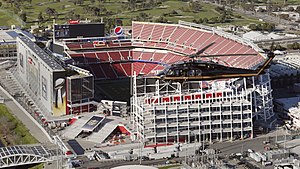
Levi's Stadium
Football stadium in California, U.S.
Distance: Approx. 1452 meters
Latitude and longitude: 37.403,-121.97
Levi's Stadium is an American football stadium located in Santa Clara, California, just west of the much larger city of San Jose, in the San Francisco Bay Area. It has served as the home venue for the National Football League (NFL)'s San Francisco 49ers since 2014. The stadium is located approximately 40 miles (64 km) south of San Francisco.

Santa Clara–Great America station
Railway station in Santa Clara, California
Distance: Approx. 1275 meters
Latitude and longitude: 37.406645,-121.96688
Santa Clara–Great America station (called Great America station by ACE) is a train station in Santa Clara, California. It hosts Amtrak's Capitol Corridor trains and Altamont Corridor Express (ACE) trains. The station is close to Levi's Stadium and California's Great America.

Santa Clara Convention Center
Distance: Approx. 1132 meters
Latitude and longitude: 37.40472222,-121.97527778
The Santa Clara Convention Center is located in northern Santa Clara, California. It serves as one of the large meeting and convention facilities in Silicon Valley, with 262,000 square feet (24,300 m2) of meeting space. It was built in 1986 and expanded in 2009.
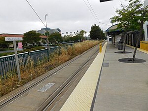
Old Ironsides station
VTA light rail station in Santa Clara, California
Distance: Approx. 1295 meters
Latitude and longitude: 37.40333333,-121.97944444
Old Ironsides station is a light rail station in Santa Clara, California operated by the Santa Clara Valley Transportation Authority (VTA) as part of the VTA light rail system. Old Ironsides station is served by the Orange Line and is the northern terminal of the Green Line. Immediately west of the station site is a pocket track and double crossover, allowing Green Line trains to switch between tracks and enabling the storage of three, 3-car trains to mobilize trains quickly after the end of an event at Levi's Stadium.
GlobalFoundries
Semiconductor foundry company
Distance: Approx. 232 meters
Latitude and longitude: 37.415293,-121.974448
GlobalFoundries Inc. is a multinational semiconductor contract manufacturing and design company incorporated in the Cayman Islands and headquartered in Malta, New York. Created by the divestiture of the manufacturing arm of AMD, the company was privately owned by Mubadala Investment Company, a sovereign wealth fund of the United Arab Emirates, until an initial public offering (IPO) in October 2021.

Saratoga Creek
River in California, United States
Distance: Approx. 990 meters
Latitude and longitude: 37.41722222,-121.98777778
Saratoga Creek is a north-northeast flowing creek in Santa Clara County, California.

Calabazas Creek (Santa Clara County)
River in California, United States
Distance: Approx. 967 meters
Latitude and longitude: 37.41722222,-121.9875
Calabazas Creek is a 13.3-mile-long (21.4 km) northeast by northward-flowing stream originating on Table Mountain in Saratoga, California in Santa Clara County, California, United States. It courses through the cities of Saratoga, San Jose, Cupertino, Santa Clara and Sunnyvale, culminating in the Guadalupe Slough in south San Francisco Bay.
Anything's Possible
Public artwork in Santa Clara, California, USA
Distance: Approx. 1259 meters
Latitude and longitude: 37.4044,-121.9714
Anything's Possible is a public artwork by artist Linda Serrao, located by Levi's Stadium in Santa Clara, CA, United States. Anything's Possible is an installation of two over-lifesize bronze figures, commissioned by the City of Santa Clara. The installation depicts a 7' Quarterback preparing to pass the football to a young fan.
Balaji Temple San Jose
Hindu temple
Distance: Approx. 1308 meters
Latitude and longitude: 37.42386246,-121.96757507
The Balaji Temple of San Jose is a Hindu temple located in San Jose, California. Balaji Temple is a spiritual, non-profit organization dedicated to sharing the universal truths of the Vedas and Upanishads in India. The temple was established by Swami Narayananda in the year 2006 in Sunnyvale.
Weather in this IP's area
clear sky
15 Celsius
15 Celsius
12 Celsius
17 Celsius
1011 hPa
89 %
1011 hPa
1011 hPa
10000 meters
06:44:45
19:26:22